Logan, Utah was once a gathering place for the Northwestern Band of the Shoshone Indians. The Shoshone were a nomadic tribe so they had no permanent homes in the area. Mountain man Jim Bridger made his way down the Cache Valley in the 1820s, trapping beaver for the fur trade. The town itself was started in 1859 when Brigham Young directed a group of settlers to build a fort along the Logan River. The town grew and took the name “Logan” after fur-trader Ephraim Logan. Because of its abundant water, Logan became a farming community and mill town. Brigham Young College opened its doors in 1878 and was later renamed Utah State University. Today, Logan is a sleepy city with a reputation for being a safe and clean town to raise a family. There are several theatres in town providing year-round entertainment and the university helps bolster the local economy. I also thought the temple was one of Utah’s finest. I wasn’t in Logan long, but I had a pleasant stay. I hope you enjoy these photos from my time in Logan, classic Utah in Cache County.
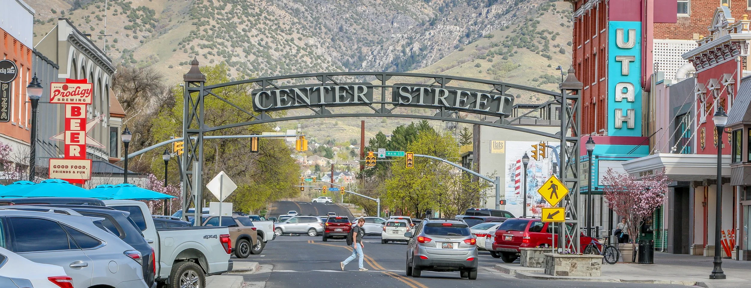
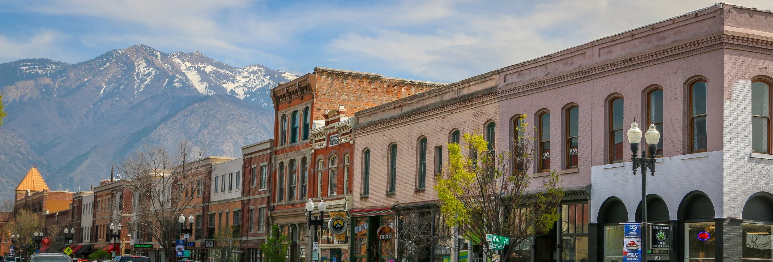
Ogden was home to Fremont Indians for centuries and was later the territory of the Northern Shoshone and Goshute tribes. Fur trader Miles Goodyear made his way into the valley in 1846 and set up a trading post he named Fort Buenaventura. I’m sure the Mormons were surprised to find him there when they arrived in 1847, but they bought his fort and began building a town there along the Ogden and Weber Rivers. The town they built was named Ogden after mountain man Peter Skene Ogden and became the second city in Utah to be incorporated after Salt Lake City. The whole area would change twenty years later when the transcontinental railroad came through Ogden, choosing the northern city over Salt Lake because its route went around the north shore of the Great Salt Lake. A spur line would be built to Salt Lake, and Ogden would become known as “Junction City”. With the railroad came tremendous shifts in the population and Ogden went from being a quiet Mormon city to a rowdy railroad town. It would also become one of Utah’s most diverse cities with an influx of Chinese laborers and Black train porters. All of the action would center on 25th Street which is still the main drag today. Later the Lincoln Highway would also come through Ogden, furthering its reputation as a major crossroads of the west. Today Ogden is tamer than it once was, but is still one of Utah’s least Mormon-influenced cities with an abundance of bars and clubs throughout. I found Ogden to be a fun and vibrant place with wonderful museums, some great historic buildings and yes, better than average nightlife for the Beehive State. I had a great visit and will definitely be back in the future. I hope you enjoy these photos from Ogden, Utah’s “Junction City”.
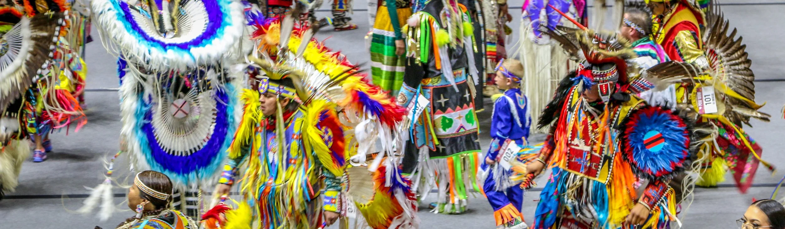
It was truly a privilege to once again be able to attend a Native American powwow. Powwows are gatherings of American Indians to celebrate their shared culture with an emphasis on music, drumming and dance. Threading Our Legacies Powwow was held at the basketball arena on the University of Utah campus in Salt Lake City. The Ute, Shoshone and Navajo tribes seemed to be the most well-represented tribes there, but it also seemed as though people had come from far and wide to participate. During the Grand Entrance which begins the powwow, hundreds of dancers followed the eagle staff and flags onto the floor and there were at least 5 drum groups to provide the rhythm of the day. Powwows are incredibly colorful events with participants wearing beautiful regalia which takes many hours to create. These photos are just a small sampling of the people who participated in the day but I hope they will give you some idea of how beautiful it was and how awesome it was to be there.
Hello Everyone!
Greetings from Pocatello, Idaho and Happy April to you all. I crossed the border into The Gem State yesterday morning and it is nice to be here. Leaving a state always feels bittersweet to me. After 5-6 weeks I feel as though I have a pretty good understanding of the people, places, history and culture of a state which is, of course, the whole point of this adventure. And then when I reach that point, it is time to move on and start fresh but it’s always a little sad to leave the familiar for the unknown. I can’t say enough good things about Utah and the last six weeks I spent in The Beehive. From tracing the trails of The Ancients to old cliff dwellings and petroglyph panels to following the Mormon pioneers as they spread out to create their New Zion to exploring truly incredible natural landscapes, Utah has really given me so much to be thankful for. I have loved almost every minute of my time in Utah and certainly look forward to returning in the future. That said, I’m also looking forward to the next few weeks here in Idaho and to seeing everything it has to offer. I hope you’ll come along for the ride.
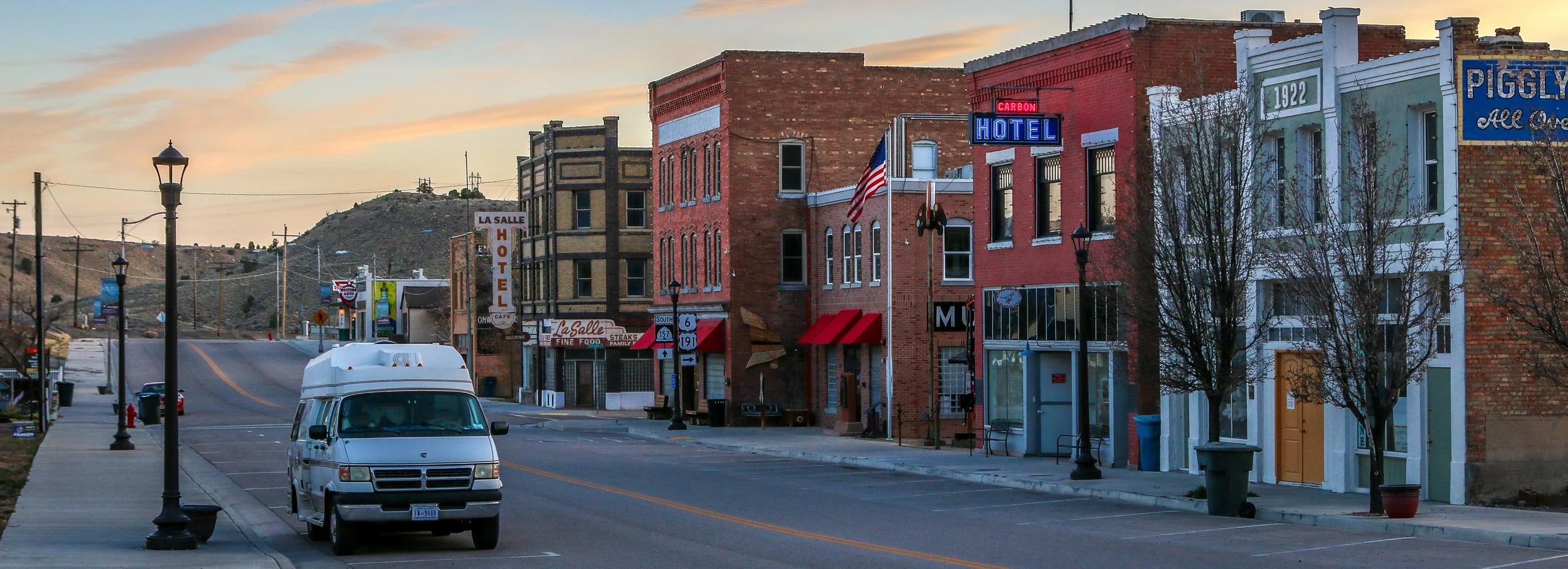
Pulling into tiny Helper, Utah is like stepping back in time. Whatever way you come into town, you are likely to drive past one of their amazingly preserved vintage gas stations on your way in. These are perfect inside and out and you should definitely stop to check them out. When you pull onto Main Street, you will definitely be impressed by how well they have kept up their historic district and it feels like you are on a movie set somewhere. The only other place I have visited that had the same feel was Lowell, Arizona, but Helper feels more alive and less like a ghost town.
Located in Carbon County, this is definitely coal country, but the town developed around the railroad when the Denver and Rio Grande Western Railroad (D&RGW) came through in 1881. The town gets its name because the trains needed an extra push to get them over the next hill, so an extra engine, or “helper” was attached. Between the mines and the railroad, Helper grew to a population of around 20,000 people who came to work in these industries from all over the world. The mines and the railroad still exist in the area, but increased mechanization has decreased the need for workers and the population has dropped by 90%. That said, the people who have remained decided to do what they could to preserve the history of the town and have worked hard to create the Helper you’ll find there today.
I was thrilled to find the Matt Warner Lodge of E Clampus Vitus while I was there. ECV is the historic organization I’ve been a part of for the last 20 years or so, but this is the only Lodge in all of Utah. They are working hard to preserve the history of the area while helping run many of the community’s events like the Easter egg hunt, which they were all excited about while I was there. It was nice to have some company for a change, and the Brothers filled me in on a lot of the local history. Their Lodge is located in the historic Carbon Hotel which was the last functioning brothel in Helper and was open into the 1970s. ECV historic plaques can be found throughout Helper and in many nearby towns and help tell the story of the communities which have long since faded into the past.
If you’re ever on your way to Salt Lake City from Moab or Grand Junction, definitely be sure to stop in Helper, you’ll be glad you did. I hope you enjoy these photos from Helper which is definitely Utah’s cutest small town.
Hello Everyone. It’s been a pleasant and reasonably slow week here in Utah. The temperatures have definitely gone up significantly and it feels like we are jumping right from winter to summer out here. I’ve spent plenty of time in Utah in summer in my life, so I know that’s not exactly true, but going from 40°F to 85°F is still a significant jump in a week. I’ve spent most of the week in the Greater Salt Lake City area, an area I’ve spent a decent amount of time in in the past but have never really had an opportunity to explore. I went to an amazing American Indian Powwow, learned more about the Mormon faith and history and generally enjoyed my time out in the Salt Lake Valley. This may have been my last full week here in Utah, and closing out my time in a state is always bittersweet. I’ve really enjoyed these last 5 weeks in the Beehive State, and I’ve certainly learned a lot about what makes it tick. That being said, the warmer temperatures are going to push me north and into the mountains, which is what I’ve been looking forward to all winter. Anyways, I don’t want to get too far ahead of myself, so let’s get right into how I spent my week here in north-central Utah.
After finishing up this post last week I used the rest of the daylight to cruise on up the road to Delta. Along the way I was excited to visit the town of Harding (my last name), but it turned out to only be a crossroads – no sign, no buildings, no nothing. That was disappointing, but the sun was already down when I got there, so I continued on and had a quiet night when I got to Delta. On Thursday morning I started my day with a visit to the Topaz Museum in the heart of downtown Delta. I got there right when the museum was opening and the docent who was there was a former Delta schoolteacher who spent a nice bit of time introducing me to museum.
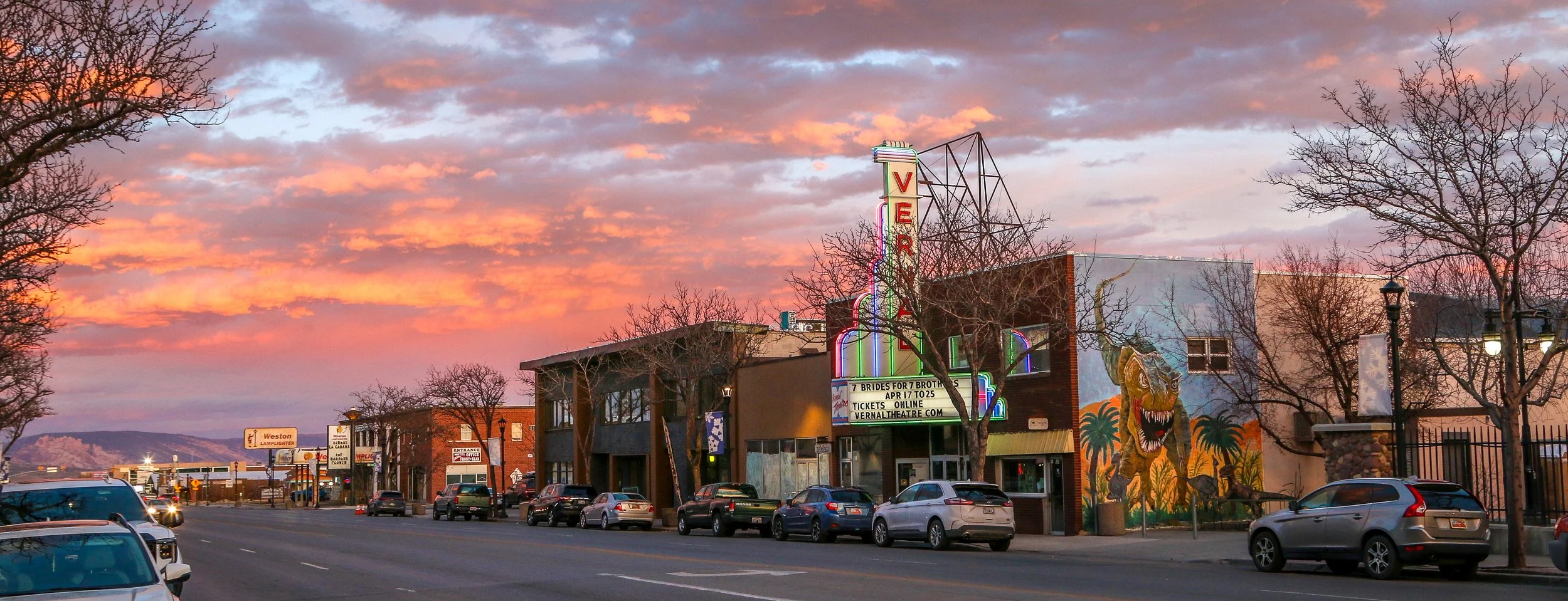
I had a blast in Vernal, Utah - a fun little city of about 10,000 people in the far east of the Beehive State. Fremont Indians once lived in the area and were later followed by Utes who still live there today. When the Mormons came to Utah, they saw no reason to settle in the region despite the Green River flowing nearby. In fact, settlers didn’t come to what is now Vernal until 1879. The railroad came through in 1906 and Vernal was incorporated and began to grow. Just three years later, paleontologist Earl Douglass discovered a massive deposit of dinosaur bones and fossils just east of Vernal and it would be designated as Dinosaur National Monument in 1915. Oil and mineral extraction are probably the biggest drivers of Vernal’s economy, but dinosaur tourism certainly plays a significant role, as you can tell from the photos in this post.
I was only planning on staying a short while in Vernal, but ended up there for several days. I enjoyed checking out the dinosaur quarry at the National Monument, and the Field House Museum in the middle of town. The recreation center was top-notch and I even got to catch some bull riding while I was there. Mostly, it’s just fun town with a good feeling to it and friendly people at every stop. That and the sunsets were hard to beat. I hadn’t been to Vernal in many years and I was glad I made the trek to get there. I hope you enjoy these photos from Vernal, definitely a fun town in the heart of dinosaur country.
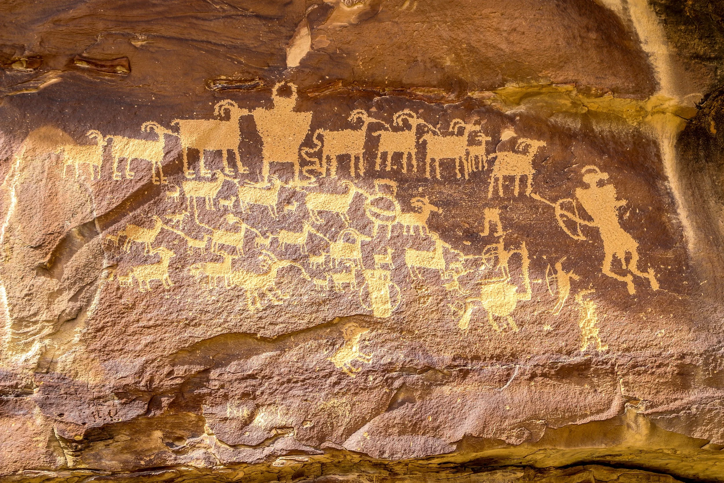
Nine Mile Canyon as often been called “The World’s Longest Art Gallery”. Despite its name, the canyon stretched 46 miles through east central Utah and has as many as 10,000 petroglyphs along its course. This route has been traveled for thousands of years, undoubtedly beginning as a wildlife trail which followed the easiest path through the mountains. It was used by a people we refer to as the Fremont People for many hundreds of years and they are responsible for most of the petroglyphs chipped into the canyon walls. Later, Ute Indians made their way through the canyon and made their own carvings, including those of horses and bison. Fur trappers and settlers followed the old Indian trails. The Nine Mile Canyon Road was originally built by the Black Buffalo Soldiers of the Ninth Cavalry to connect old Fort Duchesne to the railroad at Price. Once the road was complete, stagecoaches started using the canyon to deliver mail and freight and settlements began to spring up. Later, mining and natural gas extraction began in Nine Mile Canyon and continues today. Nobody knows how 46 mile long Nine Mile Canyon was named. Many people believe that explorer John Wesley Powell named it because the name first appears in his journals, but Powell was pretty good at naming things so I’m not buying that explanation. Also, I love a good mystery and don’t mind when one goes unsolved.
I started my drive from Wellington, just south of Price. The road is paved all the way to the Great Hunt Panel (and beyond if you continue up the side canyon), but has a stretch of decently maintained gravel road if you want to continue through to Myton (which I did). I loved seeing so many wonderful petroglyphs in such a small area and I know I only scratched the surface (pun intended) of what was out there. My favorite is the first one pictured below: Coyote Placing the Stars. I also loved the Owl Panel and the Juggling Man and of course the Great Hunt which is one of Utah’s most famous panels. There were a lot of old homesteads along the way and even an old townsite once called Harper but abandoned over a hundred years ago. There are some beautiful new homes out there as well and aside from the mining trucks rumbling past I imagine it’s pretty quiet out there most of the time. I really enjoyed my day out in Nine Mile Canyon and I hope you enjoy these photos I took along the way.
Hello Everyone. A belated Happy St. Patrick’s Day to you all from here in Fillmore, Utah. I’ve spent this last week cutting across the central part of the state, checking out petroglyphs and dinosaur fossils in the east, cruising down the beautiful agricultural region of the Sanpete Valley and finishing up here in Utah’s first territorial capital. It’s been windy out here this week, but the temperatures have been pleasant and the rain and snow have stayed away, which was a good thing as some of these high mountain passes have taken me up above 9000’. Central Utah is definitely a less-visited part of the state, but it has a lot of cute towns, friendly people and plenty to keep me busy. I’ve been moving fast this week because there’s a powwow I want to get to in Salt Lake City this coming weekend and these are all places I wanted to hit before heading in that direction.
When I left you last week, I was out in Grand Junction, Colorado after a quick visit to Colorado National Monument. After I wrapped up my newsletter, I made a beeline back to the Beehive State and headed straight to Green River. I wanted to get there with enough time to see the John Wesley Powell River History Museum. If you don’t know of him, Powell led the first expedition to float the length of Grand Canyon. A retired U.S. Army Major, he had lost his right arm due to a gunshot through the wrist he received during the Battle of Shiloh, one of the bloodiest and most fascinating battles of the Civil War. After the war, he went on to become the curator of a small natural history museum in Illinois and went west to gather some samples for the museum. While there, he became fixated on the idea of exploring Grand Canyon and collected a rag-tag crew of mountain men and explorers to come with him. It was quite the adventure and this museum does a good job of documenting their trip and providing some great information on Powell himself. There are also displays on the geologic and human history of the Green River (which joins the Colorado River in what is now Canyonlands National Park and which Powell floated to get to the Colorado on his journey). In addition to the permanent gallery…
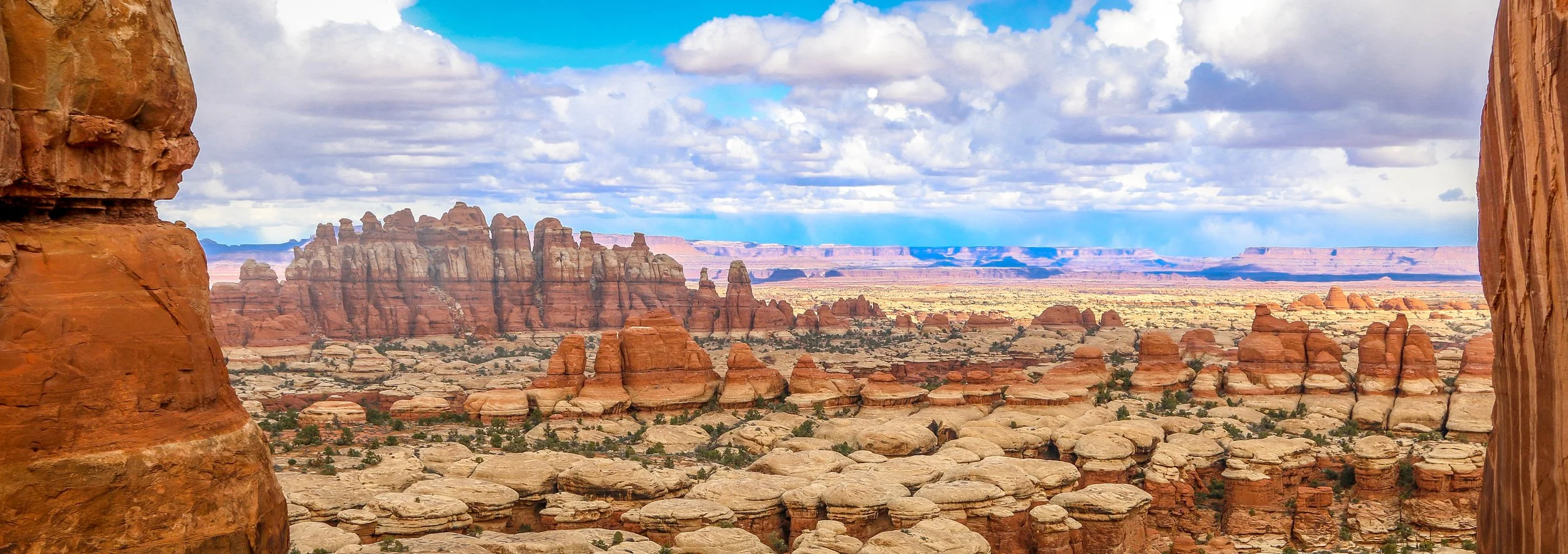
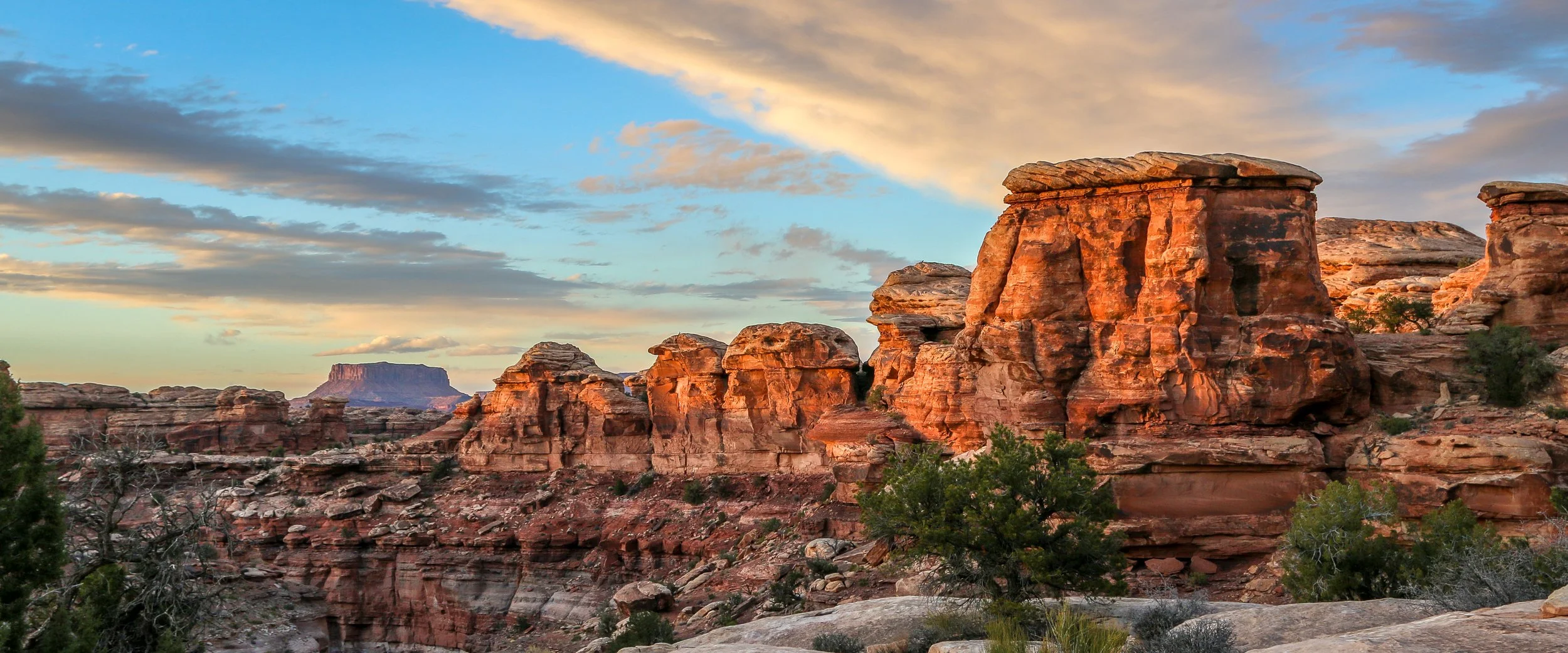
Canyonlands National Park is one of the most beautiful National Park’s in the country. Originally proposed by the superintendent of nearby Arches National Park in the early 1950s, debate over the area’s mineral resources kept this land from being protected until 1964 when President Lyndon Johnson signed it into law. Canyonlands is divided into four different sections: The Island in the Sky, The Needles, The Maze (which includes Horseshoe Canyon) and the Green and Colorado Rivers which come together within the park’s boundaries. It’s a geologic fantasy land of spires and canyons, buttes and mesas, caves and rapids. Like most of the area, Canyonlands’ scenery is at its best along the edges of the day when the sun is low and the sandstone takes on magical hues. I have really enjoyed visiting Canyonlands several times over the years, but my recent visit to The Needles was definitely the highlight for me, especially the hike out to Chesler Park from Elephant Hill. I hope you enjoy these photos from beautiful Canyonlands National Park.
Hello Everyone! Greetings to you all from Grand Junction, Colorado. As I mentioned last week, I have just dipped over the border for the day because I wanted to pay a quick visit to Colorado National Monument. While I’m here I got some groceries and now I’m going to hole up in the library and get this week’s newsletter done before returning to Utah later today. Crossing into another state is fascinating when you’ve really dug in somewhere for a few weeks and have been paying close attention to the culture of a place. Crossing from Nevada into Utah or Utah into Colorado is very much like crossing into a different country. Not like going from Sweden to Uganda, but more like going between England and Wales or between Cambodia and Laos – there are plenty of similarities, but they’re also remarkably different. I’ve really been enjoying my time in Utah and this feels like I’m cheating on it, but I’m sure Utah will get over it and I’m really looking forward to the rest of my time in The Beehive State. I’ve spent more of this last week on the trail than on the road, and that’s been an excellent use of my time. It’s been another soul-stirring week out here, so let’s get right into what I’ve been up to since last I wrote.
After I finished this post last week, I ended up spending another morning there in Blanding, a town I grew quite fond of during my three night stay. I started off my day with a quick visit to the Four Corners Cultural Park (the “four corners” refers to the shared border of Utah, Arizona, New Mexico and Colorado, the only place in the country where four states come together in a squared off fashion). I thought this cultural park was really cool because you could walk between examples of the “houses” of the different cultures that came together in Blanding. There were Ute teepees, Navajo hogans, a Mexican hacienda and Mormon pioneer cabins all within a short walk of each other and I thought it was just a neat place to check out. From there I went to the museum at Edge of the Cedars State Park which displays cultural artifacts found around the area and interprets the cultures which came before the modern inhabitants of the region. The museum’s pottery collection is remarkable and it’s amazing to see the artistic expression of the people who made these items. These bowls and jugs were not simply utilitarian, they were beautifully crafted and then painted with precise geometric designs and were all very impressive. The museum also had a beautiful macaw shawl which has kept its bright coloration for over a thousand years. I always find the macaw feathers found here fascinating because they are evidence of the vast trade networks of these earlier cultures which stretched deep down into what’s now Mexico (where macaws were commonly found). I’m sure this one cost someone a few beautifully crafted pottery items in trade. The museum was fabulous, and the ruins out back were okay but not nearly as good as so many others I have visited in the last few weeks.
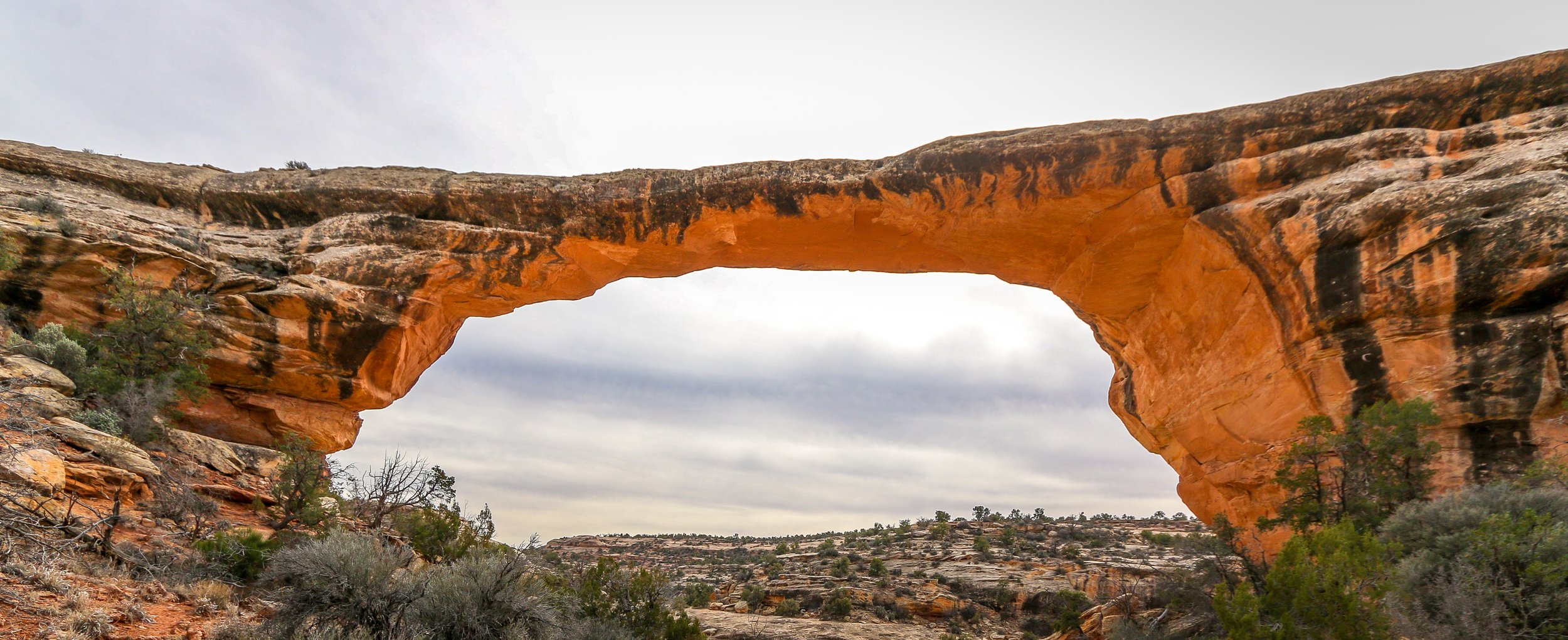
Natural Bridges National Monument became Utah’s first National Monument in 1908. It protects three impressive natural bridges situated in White and Armstrong Canyons in the southeast part of the state. A natural bridge is geologically different from an arch in that a bridge is formed by running water whereas an arch is not. Utah has quite a few of both.
The human history of this area stretches back at least 9,000 years as archaeologists have found tools and other evidence dating to that time. Ruins in the park show that the Ancestral Puebloans inhabited the area from around 700AD to around 1270AD. In more recent times, Paiute and Navajo people have made their homes in and around these canyons. in 1883, a man named Chris Hite wandered up White Canyon in search of gold and brought word of these magnificent natural bridges to the outside world. National Geographic did a story on the bridges in 1904 and in 1908 Theodore Roosevelt designated them a part of a new National Monument. Very few visitors came in the early years of the park as it was a three day horseback ride from the nearest town. A uranium boom in the 1950s brought roads to the area and those roads were paved in 1976, allowing easier access to see the bridges.
Natural Bridges National Monument is a beautiful place. It’s quiet and remote and definitely off the beaten path. Unfortunately, I imagine most people visit on their way between one place and the next and only stop at the overlooks to get a look at the bridges. To really appreciate them, you need to hike down into the canyon and get a closer look. The trail to Sipapu Bridge is an adventure in its own right, descending several ladders on the way to the canyon floor. Getting down to Kachina and Owachomo Bridges is easier, and I even enjoyed hiking between these two along the canyon bottom. Like most of the Desert Southwest, the natural bridges are at their best at the edges of the day when the sun is low and the sandstone lights up. I hope you enjoy these photos from beautiful Natural Bridges National Monument, well worth the detour if you’re ever in the area.