In June of 1867 a small group of soldiers from Fort Bridger, who were in the area to help protect the overland trails coming through South Pass, decided to try a little prospecting during their down time. They came up lucky and soon a small gold rush brought 2,000 people up the mountain, and South Pass City was born. The mines and the town would both go through a series of booms and busts over the next 90 or so years until, in 1968, the whole town was bought by the state of Wyoming and was designated a state park. The Carissa Mine was bought in 2003 and added to the park. Extensive restoration of the town makes it seem as if the citizens just left yesterday, leaving the store fully stocked and half drunk beers on the bars. The Carissa Mine and Mill are incredible to see as not only have the buildings been restored and stabilized, but much of the machinery is in working order. I had a great visit to South Pass City and found the whole place fascinating. They had a great display outlining South Pass City’s role in giving Wyoming women the right to vote back in 1869 and it was also home to Esther Hobart Morris, the country’s first female Justice of the Peace. You can even get a cold sarsaparilla in one of the saloons. I hope you enjoy these photos from old South Pass City, a beautifully restored Wyoming gold rush town.
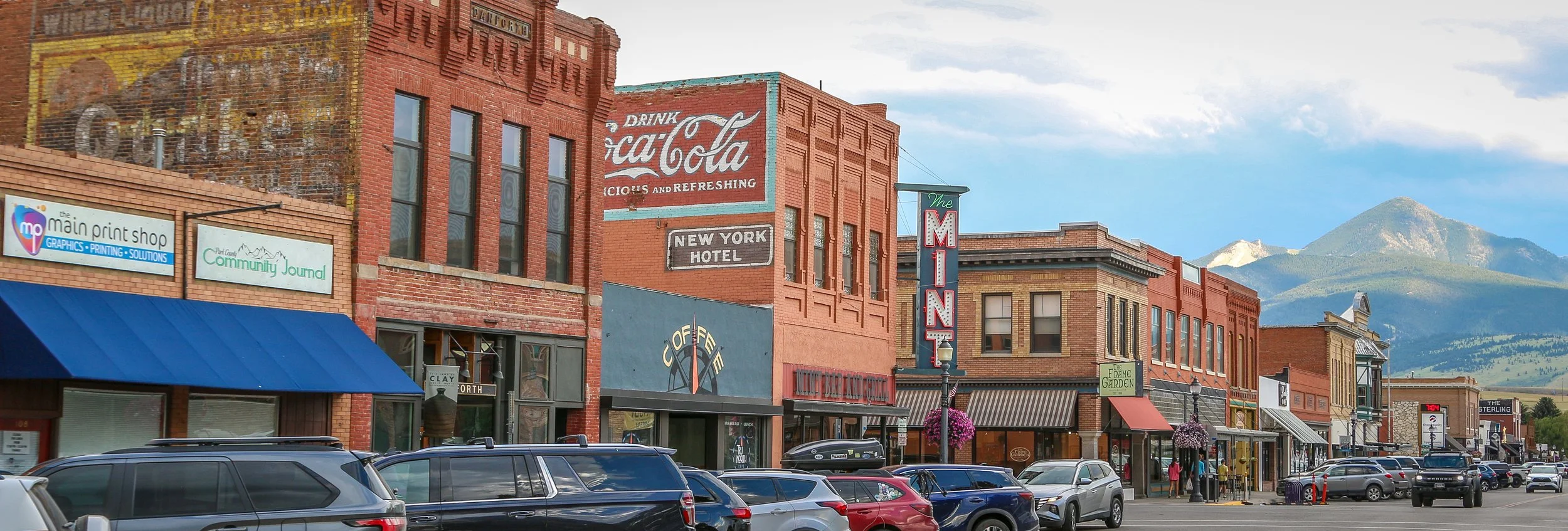
The Northern Pacific Railway came to southern Montana back in 1882 and the town of Livingston was born. Named after a railway stockholder, Livingston slowly grew to its current population of about 8,000 people. In the early days, it was marketed by the railroad as the “Gateway to Yellowstone” and they even laid down a branch line which ran from the main line all the way down to Gardiner on the park’s northern border. Livingston is still a popular gateway to Yellowstone, although you have to drive there now. The town maintains a lot of its historic character with beautiful old buildings, classic neon and awesome painted advertisements and ghost signs. I arrived in Livingston during a heat wave, ended up sticking around for a couple of days and really enjoyed it. There are some nice museums and a lot of great bars and restaurants. I hope you enjoy these photos from Livingston, Montana’s historic “Gateway to Yellowstone”
Hello Everyone!
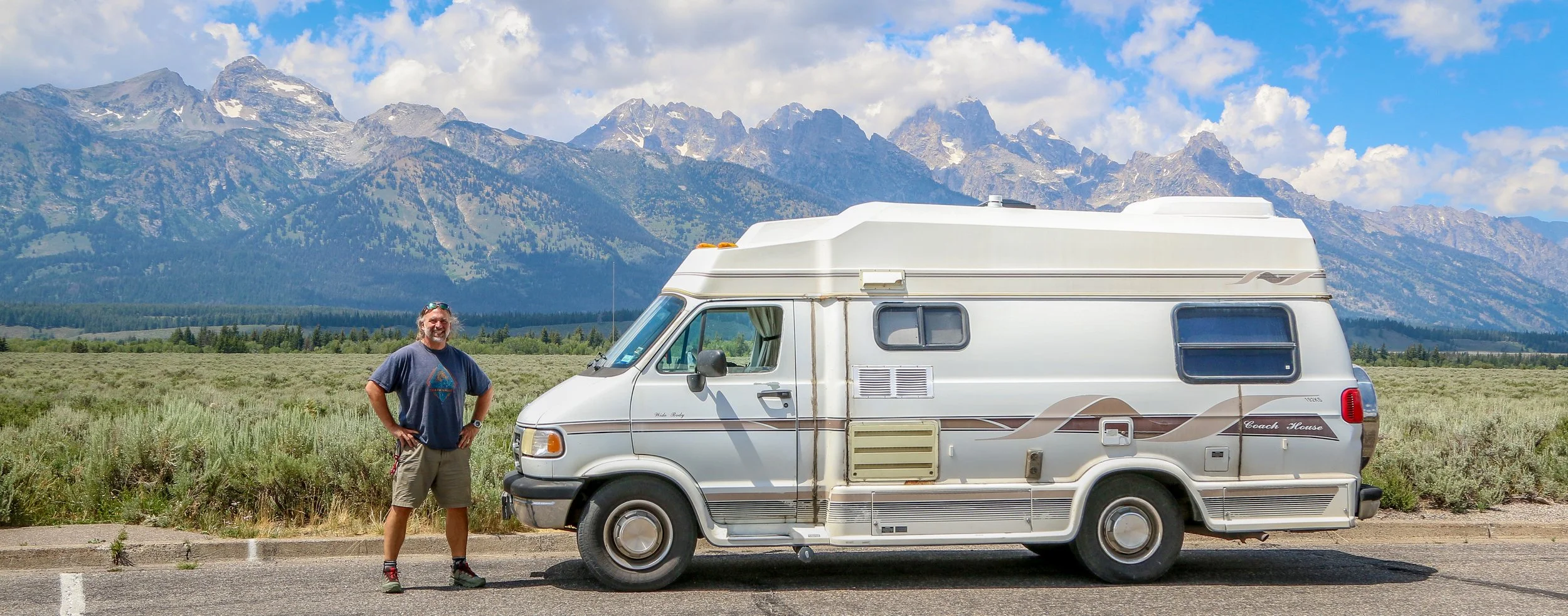
It’s been another hot week out here on the road in central Wyoming. July is historically the hottest month in both Wyoming and Montana, but this summer has brought record temperatures to both. Daytime temperatures are once again nearing 100° out here, but thankfully it’s been cooling off enough in the evenings to sleep in my van. I’ve been up and out early most days to get my driving done before it gets ridiculous out and have definitely been trying to scout out some shade whenever possible. Despite the heat, I’ve had an interesting week out here exploring some of central Wyoming’s small towns and what they have to offer. I also spent some time on the Wind River Reservation this week, home to the Eastern Shoshone and Northern Arapahoe Indians. Wyoming is the least populated state in the country and it’s definitely not hard to imagine that out here. Big lettered towns on the map are relative and mean that these are big towns for Wyoming, but not necessarily big towns. With only around 588,000 people in the entire state, Wyoming’s whole population is slightly more than that of Baltimore, Maryland and slightly less than Memphis, Tennessee. I definitely enjoy the small towns and the wide open spaces of the Cowboy State, and I’ve been happy to see so many new-to-me places this week.
After leaving you last week I headed out into the night there in Jackson. I’ve certainly seen a lot of changes in Jackson over the last 25 years since I first visited, and every year it gets a little more L.A. and a little less Wyoming. The place that continues to roll with all of the changes is the infamous Million Dollar Cowboy Bar right there on the town square. The Cowboy Bar opened its batwing doors back in 1937 and has always been a central gathering place for the town. It’s decorated with burled wood beams, taxidermied animals and cowboy relics and even has saddles in place of barstools. With live music every night, I’ve never been there when it wasn’t busy. On any given night, you’re likely to find locals and tourists, cowboys, rafting guides, drifters and beauty queens shooting pool, shooting whisky and tapping along to the band. This night was no different and I enjoyed a few cold ones and a few tunes while I chatted to some folks from Charlotte, N.C. who were in town for a wedding. Long live the Million Dollar Cowboy Bar – may it continue to evolve with the town and somehow still remain exactly the same as the first time I walked into it.
Hello Everyone,
I have had a wonderful week out here in the Rocky Mountains, having spent most of the week in Yellowstone National Park. I didn’t put a lot of miles on my van, but put in right around 50 miles on my hiking boots which has been exhausting but exhilarating as well. I’ve spent a decent chunk of my life in Yellowstone, having guided tours there for over 25 years, but it’s still nice to be there. I also know that I’ll be back in Yellowstone in the future on the company dime, so there really wasn’t much need to visit any of my favorite spots (which are also, not surprisingly, major highlights of the park). Instead I wanted to do some hikes that have been on my radar for a while and really get into the backcountry and explore some new corners of Yellowstone I’ve never been to before. The result was a fairly quiet and peaceful week in a spectacular setting, despite it being the highest of the high season out there. I’ve always told anyone who was interested that if you get tired of the crowds in Yellowstone, walk a half mile down a trail from any parking lot and you’ll find a much quieter place. Walk 10 miles down a trail and apparently you won’t see hardly anyone at all. Aside from the hundred or so mosquito bites covering my body and a few raw patches on my feet, I’m feeling great. My mind is clear, my body feels strong and healthy and I was able to declutter a lot of things in my head this week. So it’s been a pretty great week on the road and on the trails out there in Yellowstone.
After finishing up this post last week, I went out to have a couple of beers in Livingston while the sun headed towards the horizon and the day cooled off a bit. I went back to Katabatic Brewing Company for a beer and ended up chatting with a man about my age who was from Chicago. He was traveling through and we had a nice conversation about where he had been and where he was headed. After the brewery closed, we went next door to the Murray Bar and continued talking. There was another man at the end of the bar who joined the conversation and he turned out to be from Tacoma Park, Maryland, just outside of my hometown of Washington D.C. It was really nice to be able to connect with someone from home for a bit. He was a teacher on his summer break and was heading west to visit his dad in Santa Cruz. He had just bought a new car, a Hyundai Santa Cruz and I found it quite amusing that he was driving his Santa Cruz to Santa Cruz. He was on his way to Yellowstone the next day and I was happy to point him in some good directions so that he could make the most of his time there. It was a nice evening and very nice to make both of their acquaintances.
Hello Everyone,
It’s been a hot week here in Montana. Two weeks ago it was snowing in Butte and two days ago we were hitting record high temperatures across the state. It’s been dangerously hot out, especially since I have no air conditioning in my van. I’ve been holed up here in Livingston for a few days and spent the last two nights in a nice, air conditioned hotel room. It was a nice break from the road and from the heat, but it’s frustrating to feel penned in and not be able to go exploring. It’s been a tough summer so far, and the heat is not making things any easier. I’m much better at dealing with the cold than dealing with the heat and my van is the same. That being said, I did get out and see some cool places this week and I’m very grateful to have some friends to hang out with this week, as that really makes a big difference in my morale. The heat should break in the next day or two, and then hopefully it will be a little easier going.
So after I finished up this post last week, I meandered down to the little local history museum there in Great Falls. It was a cute little museum with some interesting exhibits on the history of Great Falls, one called Spirits of Cascade County: Bootlegging, Bureaucracy, and Breweries, and one about feisty Montana women (their words, not mine). There were some cool bronze sculptures and some neat miniature building models as well. They also had a really interesting exhibit in what must have been some sort of event space on the historic Ozark Club, a black owned nightclub which had opened in Great Falls the day that prohibition ended and lasted until the owner’s death. After a nice visit to the museum, I did return to the Sip ‘n Dip Lounge to watch the mermaid in her pool behind the bar. Their tiki drinks were not very good, but the show was fun and I really enjoyed being there. Leaving the lounge, I wandered around downtown a bit and then called it a night.
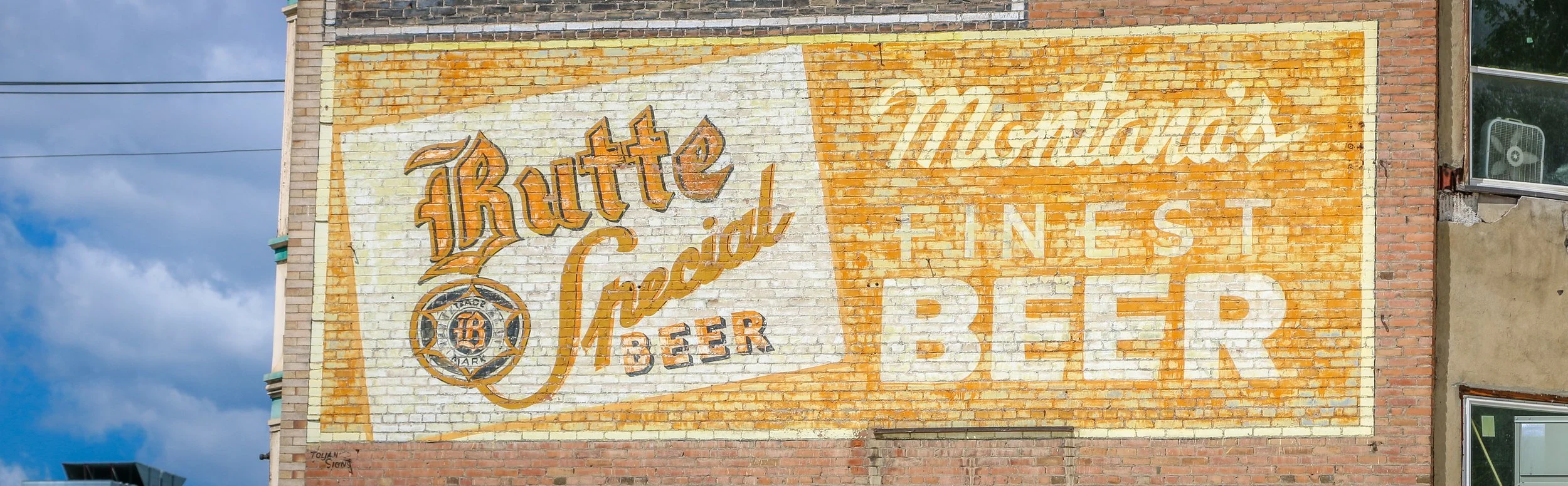
Butte began as a gold and silver boomtown in the 1860s, but it would be copper that would earn it the designation “The Richest Hill on Earth”. The townsite rests atop one of the most extensive and valuable copper deposits ever found, and when electricity was becoming more widespread around the country, Butte was supplying the copper for the wiring. There’s a very good chance that my family’s home, all the way across the country in Washington D.C., was wired using Butte copper. The city would grow as the mines expanded, with some reaching over a mile down into the earth. Miners would flock from all over the world to work those mines, creating one of the most diverse cities in the west during its heyday. Along with the miners came thousands of other people to run and work in the shops, saloons, restaurants and brothels that grew up alongside the mines. The population would grow to at least 60,000 by the 1920s, making it the biggest city between Chicago and San Francisco. As the mining process became more mechanized, Butte’s population would begin to decline and Butte today is home to only about 35,000 people.
Butte is a wonderful, old city with a ton of history and a million reminders of the city it once was. It’s one of the most photogenic cities I’ve ever been to and one I always look forward to returning to. I love Casagranda’s for an old-school steakhouse experience, Maloney’s is a classic bar and John’s pork chop sandwiches are always a treat. I hope you enjoy these photos from beautiful Butte, Montana - The Richest Hill on Earth.
Hello Everyone,
You’ll be very happy to hear that I am no longer in Missoula. I have left the mountains entirely for the moment and am writing to you this week from Great Falls, Montana on the edge of the Great Plains. It’s definitely different to see flat landscapes stretching out towards the horizon after so many months in the mountains. I do plan to loop back into the Rockies in a couple of weeks, but for now it’s just good to be on the road again and moving. It’s been a pleasant week even though I haven’t gotten too far from where I started. I spent much of the week split between Helena, Montana’s capital city, and Great Falls. Shadow Catcher is driving so much smoother than it was last week and I’m really glad I took it back in for another look. Great Falls is a great place to give it a good test, because the streets in town are absolutely terrible. I’m really hoping that the rest of the summer will be smooth sailing from here.
After I finished up this post last week, I heard from Kerry at Rocky Mountain Diesel who was taking care of my van. He told me that while they had rebuilt my drive shaft the week prior, there was still something wrong with it and it needed to go back to the shop that had rebuilt it. He told me that I could pick up my van for the night and that they would get on it first thing in the morning. It was pretty late at that point, so I picked it up and headed just down the road to Highlander Brewing Company. Highlander is a perfect example of something I’m surprised I don’t see more often in places. Highlander Beer is an historic Missoula brand first brewed in 1910 and named (with full permission) after the New York Highlanders baseball team (later renamed the Yankees). Highlander was brewed right there in Missoula until 1964 when the brewery was demolished during the construction of Interstate 90 and the beer went dormant. The branding was purchased in 2015 by a start-up Missoula Brewing Company. While they don’t brew the original Highlander beer, they sure capitalize on the name and the nostalgia with a brewery chock-full of old bottles, signs and memorabilia. The taproom is beautifully situated along Grant Creek, the beers they are brewing are pretty good and overall it’s a wonderful place to be. It’s also a quiet and easy place to park overnight which was an added bonus.
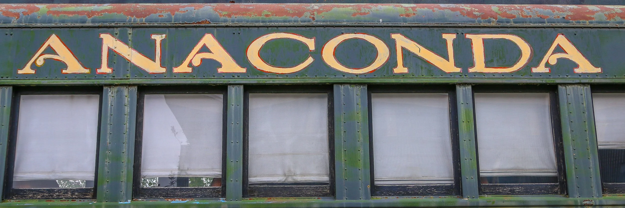
The United States is full of wonderful place names, and Anaconda, Montana is definitely one of the coolest names out there. Anaconda was founded by Copper King Marcus Daly as the location for a copper smelter to process the copper coming from the mines at nearby Butte. A smelter needs water and Butte just didn’t have a dependable enough water source to make one feasible. Daly originally called his town “Copperopolis”, but that name was already taken by another town in Montana so it was changed to Anaconda after the mountain range it is nestled in. When Montana became a state in 1889, Anaconda was in a fierce competition with Helena to become the new state capital, losing by only 2,000 votes.
Anaconda is a charming little city of just under 10,000 people. The locals are friendly and welcoming and the town itself has some really beautiful features. There are some beautiful historic homes west of downtown and some delightful bars and restaurants (don’t miss Gallicano's Pizzeria while you’re there). The Deer Lodge County Courthouse is awesome, and the Washoe Theatre is also not to be missed. I was truly surprised by how great of a town Anaconda is and I’ll definitely be back in the future. I hope you enjoy these photos from beautiful Anaconda, a true diamond in the rough.
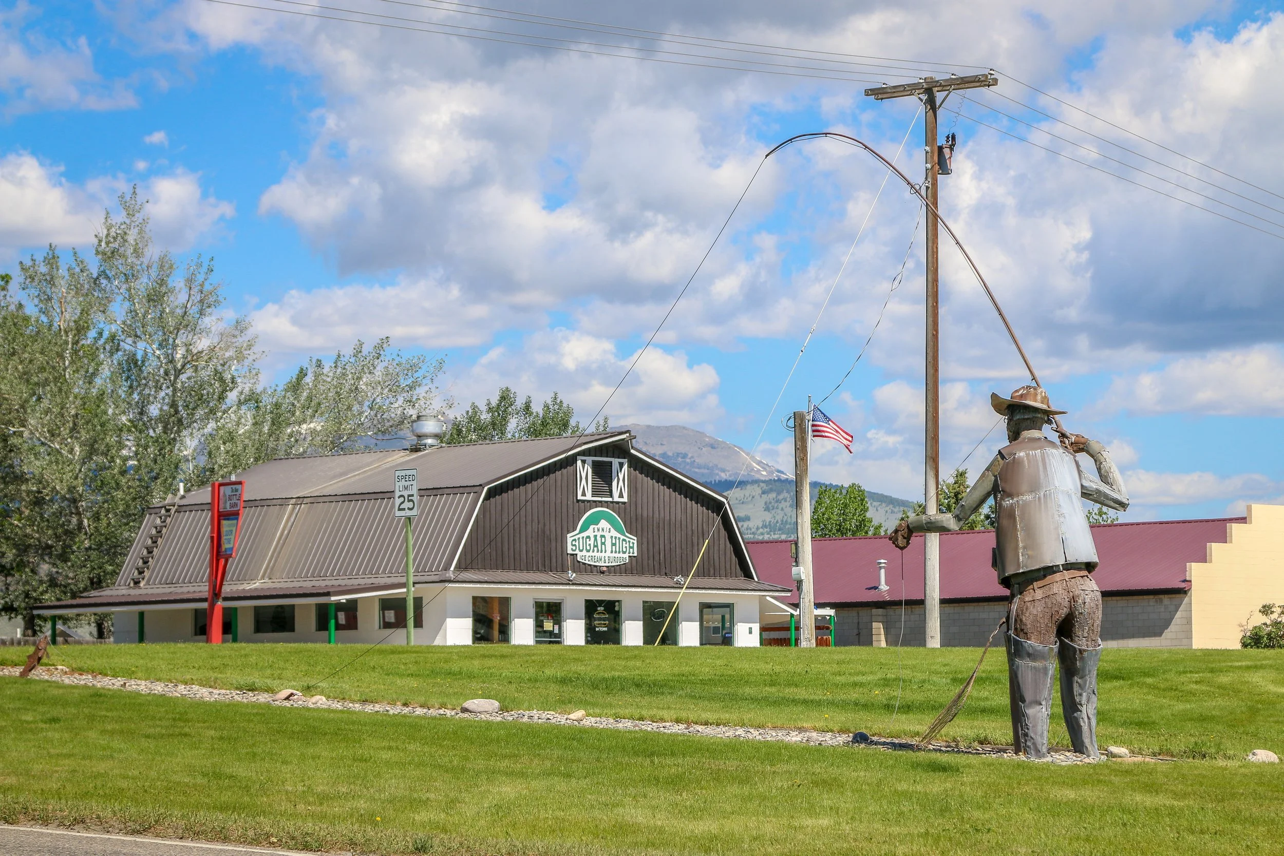
Located on the Madison River in Madison County, tiny Ennis, Montana is known for its abundant fly-fishing opportunities and public outdoor art. The area was originally settled in 1863 by William Ennis and the town that grew up there bears his name. I’ve been through Ennis a few times and always find it to be a quiet and charming little town. I hope you enjoy these photos from tiny Ennis, Montana.
Hello Everyone!
Of all the places I was hoping to be writing this post from this week, Missoula was not one of them. I had a pleasant if rainy week out exploring some nice spots in southwest Montana and heading towards Yellowstone, but by the time I got to Bozeman I had come to the conclusion that the repairs done on my van weren’t quite right. My stupid air shock continues to leak – these really are the worst designed parts I’ve ever encountered. And while sometimes I felt like we were cruising along smoothly, other times the whole van would vibrate beyond anything which was “normal”. I really didn’t want to turn back to Missoula, but on the other hand I paid a small fortune to get this work done and I expect it to be done right. Three hours back versus the whole country between me and home became an easy decision. Kerry at the shop was perfectly calm when I called him and told me to go ahead and bring it back in and they would take care of it. So here we are, back in Missoula. I’m really hoping that whatever it is, it’s reasonably easy to fix and that we’ll be back on the road by this time tomorrow, almost exactly a month after I first pulled into town.
After I finished this post last week, I was in a similar position to where I am today. I headed over to the mechanic shop with the hopes that my van would be ready. They were still working on it, and would finally hand over the keys around 8pm. I felt bad that they had stayed so late to get it done, and told them that one more day wasn’t going to kill me at that point, but they were ready to get it done and out of the shop. It sure was nice to be back behind the wheel, to start to put my things back where they belong and to sleep in my own bed. I went out and had a few beers to celebrate at the Draught Works brewery which is brewing up some great beers including one called Shadow Caster which made me smile. I had one last burger at the Missoula Club and then crawled into my van and slept and slept and slept…
Gold was discovered in nearby Alder Creek in 1863, sparking off one of Montana’s biggest gold rushes. People came from far and wide to try and earn their fortune in what is now southwest Montana. Soon after the discovery, a mining district was established and was named Verina [sic] after Confederate President Jefferson Davis’ wife, Varina. In the midst of the Civil War, this couldn’t be allowed, so the name was changed to Virginia City. When Montana Territory was carved from the existing Idaho Territory in 1864, Bannack was chosen as the capital, but the capital was moved to Virginia City just a year later. Virginia City would remain the capital for a decade before it was moved again to Helena. In the early days, a road gang called The Innocents was preying on wagons moving between the mining towns. In response, Virginia City residents formed The Montana Vigilantes who rode on The Innocents and lynched them in the streets of nearby Bannack. Virginia City is considerably quieter these days. With some lovely shops, some good restaurants and a couple of bars, including Montana’s oldest the Bale of Hay Saloon, Virginia City is a wonderful place for a wander. I hope you enjoy these photos from the cool, historic town of Virginia City, Montana’s second territorial capital.
Gold was discovered in Alder Gulch in 1863 and Nevada City sprung up almost overnight. It was a true boom and bust mining town which may have grown to as many as 2,000 residents but would dwindle down to only a hundred by the end of the decade. By 1880, the population was down to 50 and it would continue to shrink until Nevada City was all but a ghost town. In the 1950s, former state senator Charles Bovey decided to revive the old town as an outdoor living history museum. He salvaged a dozen or so buildings which were original to the townsite and then started bringing in other historic buildings from around the state. Today, Nevada City is owned by the State of Montana and managed by the Montana Heritage Commission. I unfortunately arrived after it had closed down for the night, but there was still plenty to see from the street. I’ll definitely have to get back and explore it another time. I hope you enjoy these photos from historic Nevada City - where Montana history comes to life.