Most of the states I’ve been to seem to have a town like Solvang - a place with solid European roots that has developed into a tourism draw over the years. Some of my favorites have been Helen, Georgia, Frankenmuth, Michigan, New Ulm, Minnesota and Helvetia, West Virginia. All of these have had either a German or Swiss background, which made the Danish village of Solvang different and quite fun for me to explore.
The area where Solvang now stands was originally Chumash land. In 1804, the Spanish built Mission Santa Inés, one of 21 Catholic missions they would establish in Alta California to try and convert the native peoples and help the Spanish claim to the territory. After Mexico won its independence in 1821, the mission system was dissolved and the land was divided into land grants and this area became part of Rancho San Carlos de Jonata.
Beginning in 1850, many Danish immigrants began arriving on America’s shores including some of my ancestors on my father’s side. Communities would begin to form, especially in the Midwest. In 1910, a small group of Danish men decided to try somewhere a little warmer and purchased land in the Santa Inés Valley. A year later, a town plan had been drawn up and Solvang was born.
Originally, the town looked like many others in the region but after World War II many buildings were built or rebuilt in a more Scandinavian style. Today, Solvang is definitely an eye-catching place, especially the windmills which are scattered around the town. Tourism is a major draw with people coming from all over the world to visit the delicious bakeries and restaurants.
I had a great time in Solvang. It was busy but not crazy and I couldn’t help but smile as I wandered around taking these photos. It felt familiar yet different at the same time and it is definitely worth a visit if you’re looking for a break from the coastal beach towns and Mission architecture. I hope you enjoy these photos from beautiful Solvang, California’s Danish capital.
If there’s a more classically Californian beach town than Pismo Beach, I have yet to find it. Just driving into town makes your stress start to fade away and when you find a parking spot you can take a deep breath and relax - you have arrived. Pismo Beach residents have made an obvious effort to create and maintain this laid-back, surfer vibe and they’ve built a beautiful town around it. The fact that I was there on a beautiful sunny day didn’t hurt.
This area is historically home to the Chumash people, and “Pismu” was their name for the tar they found in the area which they used to seal their canoes and baskets. The Spanish Portolá Expedition passed by the beach in 1769 and after Mexican independence it would be included in José Ortega’s Rancho Pismo. A town was established in 1891 and the first pier was built in 1924. Pismo Beach was long called the “Clam Capital of the World” and these delicious mollusks drew people from miles around, but overharvesting has devastated the local clam population. Today the town states simply that they are “Classic California” and they definitely live up to that claim. While there is a lot more to California than surfing and beaches, that is the image that many people have of the Golden State. If that’s what you are looking for, you won’t find a better place to experience it than beautiful Pismo Beach. I hope you enjoy these photos from this classic California surf town.
Hello Everyone,
It’s been another busy week here in Southern California. I spent half of the week out on Santa Cruz Island in Channel Islands National Park which was an absolutely wonderful experience. When I returned to the mainland, I made my way south to Los Angeles and have been here since, catching up with old friends and visiting some old haunts and some new places as well. I haven’t traveled far this week, so this probably won’t be a particularly long post, but it’s been nice to get some hiking in and the sun is finally shining again.
Last Wednesday, I packed up my backpack and hopped on The Islander in Ventura for the one our crossing to Scorpion Ranch on Santa Cruz Island. The water was rough, but it wasn’t too bad and thankfully it wasn’t a long voyage. When we arrived, we met briefly with the ranger and then headed off to set up camp. It had been raining all night and most of the morning, but the sun was out and it’s always easier to set up a tent in the sun than in the rain. The campground was pretty soggy and we had been warned about branches falling from the eucalyptus trees, so choosing a good spot to set up was essential. After getting my tent up and ready, I decided to use whatever sunshine was left to hike up to the Potato Harbor overlook. This was only about a 4 mile round-trip hike, but it was really muddy on the trail. The mud had a high clay content too, so it stuck to my shoes and it caked on so thick that it looked like I was wearing snowshoes. I made it to the overlook which was absolutely stunning and on the way there I saw several endemic Santa Cruz grey foxes. These foxes have evolved to be much smaller than their mainland cousins, and growing up on an island with no predators, they’re also very friendly. I loved watching them wander around the island and found they made me smile every time I saw them.
After having my lunch at the overlook, I could see the rain coming towards me across the ocean so I started to make my way back to camp. Unfortunately the rain caught up with me before I got there, but worse it turned the clay trail into a slick downhill path. I almost made it back to camp without falling. In fact, I could see the campground from where I fell, but my feet just went out from under me and I landed pretty hard on my shoulder. While I didn’t do any damage and didn’t even get a bruise, it hurt for a few days and I didn’t have any pain killers with me in my pack. I wasn’t happy about it, but it could’ve been worse, too. I headed back to my tent and caught a nap while the rain kept pounding down. It eased up in the evening and hasn’t been back since. That night I ate the first freeze-dried meal I’ve had in many years. When I was a teenager, I spent two summers working at a Boy Scout backpacking camp in Virginia and we ate freeze dried food most of the time. It’s come a long way since I tried it last and I must admit that it was actually pretty tasty. After dinner, the sun went down and there wasn’t much to do so I slipped into my tent and called it an early night…
Bodega, California is an adorable historic town about 5 miles from the coast and 2 hours north of San Francisco on the Pacific Coast Highway. These were once Coastal Miwok lands and they made use of the bounty of the area’s vast natural resources. Juan Francisco Bodega y Caudra of Spain first sailed into the nearby harbor in 1775, but the area’s first settlers of European decent were Russians. It was fear of the Russians’ southern advances that prompted Spain to set up the mission system and claim and settle the area of what’s now California.
In 1843, Stephen Smith built a lumber yard in the area and John Sutter also bought land nearby. St. Teresa of Avila church was constructed in 1859 and a small community slowly grew up around it. Today, Bodega’s population is still just over 200 people, but it packs a lot of punch for such a small town. Bodega is probably best known as one of the filming locations for Alfred Hitchcock’s 1963 film The Birds. I used to drive through Bodega often on my way from Santa Rosa to the coast, and I was happy that I finally had the chance to stop and look around for a while. Bodega is definitely small-town California at its best. I hope you enjoy these photos from beautiful Bodega, California.
The formations in Pinnacles National Park are thought to come from the western half of the Neenach Volcano which erupted 23 million years ago. Between then and now, this geologic formation is believed to have shifted almost 200 miles north and west thanks to plate tectonics.
This area was originally inhabited by the Ohlone people. Spanish missionaries established a mission at Soledad in 1791, just about 5 miles from the park’s current boundary. When American settlers moved into the area, they referred to the formations as “the Palisades”, and investors once considered putting a resort hotel at their base. The area was first protected as Pinnacles Forest Preserve in 1906 and then as Pinnacles National Monument in 1908. It became a National Park in 2013.
I had a great day in Pinnacles during my visit to the west side of the park. It had been raining for days and it was nice to see some blue sky for a change. I arrived early and was able to park in Bear Gulch, although there is a shuttle to bring people up from the Visitor Center as well. From there I hiked up the Condor Gulch Trail to the High Peaks Trail and then returned on the Bear Gulch Trail to the parking lot. It was a wonderful 6-7 mile loop through the pinnacles and provided great views in every direction.
The highlight of my day was definitely seeing the endangered California Condors which call the park home. I saw no fewer than 6 of them, which would be around 2% of the entire wild population of California Condors in the world. Some came so close I could’ve touched them if I’d have been sitting on your shoulders and I had never seen condors so close before. Watching them in flight is a truly special experience as they are enormous and cover a tremendous area in a short time. They move so quickly that they are tough to photograph, but there is one in the photo directly below. The condors alone were worth the visit, but I had aa awesome hike as well and it was reasonably quiet while I was there. While Pinnacles is one of the lesser known national parks in California, and for good reason, it is still a wonderful place to visit and worth a stop if you are in the area. I hope you enjoy these photos from Pinnacles National Park.
Hello Everyone!
It’s been another week of wet weather here in California. Thankfully it hasn’t been steady rain, but more on and off and I’ve been able to get out and see some things and even take a few photos. I enjoyed a fun St. Patrick’s Day in Santa Barbara and caught up with an old friend yesterday here in Oxnard. I have definitely moved strongly into Southern California this week and I’ve been having a great time. I had forgotten how much I enjoy the laid-back vibes and relaxed atmosphere of SoCal. I’m also looking forward to heading out to the island of Santa Cruz in Channel Islands National Park tomorrow if the weather allows me, so I’m going to get this post out a day early this week.
I wrote this post last week from the small but mighty town of Pismo Beach. Once I was finished putting it together, I headed out to check out the town and really fell in love with it. Pismo Beach is a quintessential California beach town full of neon and surfboards. If you grew up listening to the Beach Boys and are looking for that kind of vibe, Pismo definitely has it. I really enjoyed just wandering around and taking photos and soaking up some much needed rays. I stayed in town long enough to watch the sun set and then headed just down the road to Santa Maria.
I was very excited to have a taste of Santa Maria-style barbecue, but was also somewhat reserved in my expectations. I’ve experienced so many culinary treats around the country that I’ve learned to enjoy them in their place and then hold them in my memory until I return. Barbecue is most definitely a southern thing, and I don’t usually go for it west of Texas or north of the Mason-Dixon Line. However, since Santa Maria claims their own unique style I had to try it. I chose Shaw’s, because they’ve been around for a long time and because they had tri-tip on their menu and tri-tip (sometimes called a “California cut”) is also unique to Southern California. Tri-tip is also called “poor man’s brisket”, so I thought it would be great to try it smoked low and slow. What I didn’t look at closely enough is that Santa Maria Style is a way of barbecuing, the verb, not barbecue, the noun. It’s simply their way of seasoning and grilling meat and has nothing to do with the slow-smoked deliciousness of our southeastern region. Because of that, tri-tip was not a good choice because, while flavorful, it’s also super tough. I should’ve gone with a ribeye or a strip. My steak had good flavor and I could taste where it was going, but I didn’t enjoy it as much as I had hoped I would. It did come with a delicious soup, amazing homemade salsa, a relish tray, garlic bread and baked beans making for quite a feast, but my tri-tip was a disappointment. I will return to Santa Maria again with a different idea of what to look for though as I think it definitely has potential. The people of Santa Maria were kind and welcoming though and that would be reason enough to return.
On Thursday I continued south to La Purisma Mission, another of the 21 historic Spanish missions in California. This one had fallen into serious disrepair when it was taken over by California State Parks and was reconstructed by the Civilian Conservation Corps in the 1930s. The CCC rebuilt it to capture the historic context of the mission during its heyday so it is a fascinating place to visit and get a feel for what the missions were really like…
Hey y’all. I just wanted to share a few of my favorite shots from my time on the North Rim of the Grand Canyon. I’m doing this as a Snapshots post instead of an In Focus post because I’ll make one for all of Grand Canyon later this summer, but with any luck I will get down to Phantom Ranch between now and then, making it somewhat more complete. But I promised you some Grand Canyon photos before I transitioned to more recent California shots next week, so here you go. Enjoy!!
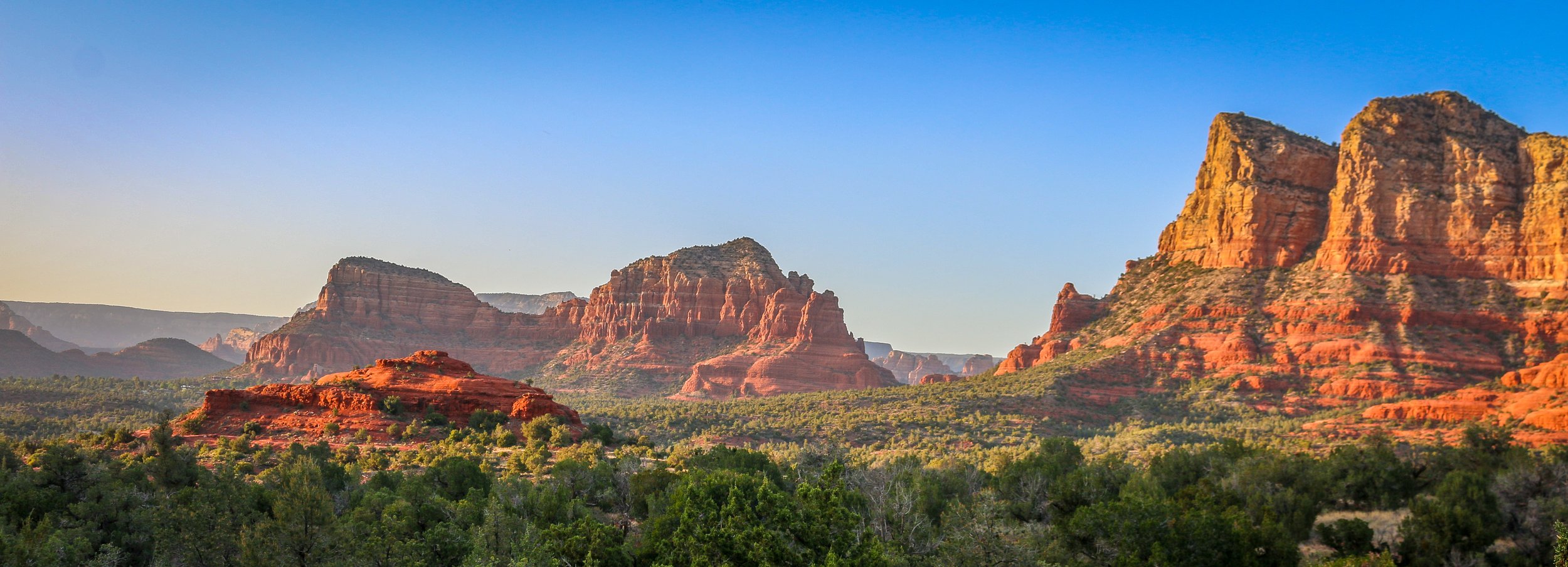
I had spent time in Sedona before, but never enough. I was always there for just a night, usually late in a tour where we didn’t have much time to do more than have a cursory look around. The cost and snobby attitudes of the locals with their spiritual vortex talk was always a turn-off for me. I had never had the chance to really get out there and do some hiking before, but I’m sure glad I scheduled a few days for it on this trip. I’ve been to a lot of places in this country, but few can compare to the red rock country surrounding Sedona. I don’t know about vortexes, but it is definitely a beautiful and magical place. Like most of red rock country, it’s best to hit the trail very early in the morning or just as the sun is starting to go down. While I was there, I hiked to the Birthing Cave, the Subway, Devil’s Bridge, the Courthouse and Bell and, my personal favorite, the Airport Loop. With the exception of this last one, which I had all to myself, there was no shortage of people in the area. It’s definitely not a secret place, nor is it off the beaten path, but it’s well worth it to visit and the shear number of trails in the area helps to disperse people pretty well. I had a wonderful few days in Sedona and will definitely be back. I hope you enjoy these photos from beautiful Sedona, Arizona, a true hikers’ paradise.
Hello Everyone!
It’s been a week of ups and downs here in the Central Valley/Central Coast of California. The weather has been challenging to say the least. The week started out with some pretty wild weather in the forecast and, as I mentioned last week, I wanted to put some distance between myself and the Bay before it hit. Crazy weather affects you differently when you live in a van than when you live in a house. At this altitude, they were calling for torrential downpours with strong winds and possible flooding. The biggest superpower of being in a mobile home is its mobility, but this storm was so big that there was nowhere to run, so it became about finding a safe spot and paying close attention to the forecast and the water levels. I had to see where the creeks and rivers were and try and stay as far uphill from them as I could without being too exposed to the wind and the lightning. I needed to avoid parking next to trees that might come over on me, but use bushes as a windbreak. It’s a little bit nerve-racking but we got through it.
There’s also obviously quite a bit of conflict in California with “vanlifers”. I’ve been in 26 states over the last 5 years in my van and this is definitely the most difficult place that I’ve been. In most of the states I’ve traveled through, most people are completely oblivious to the fact that people are living in their vans and those who know tend to think it’s pretty cool. It’s rarely been hard to find a place to spend the night that feels safe and I have felt like it’s usually pretty easy to fade into the background. That’s definitely not the case here in California as every day I see dozens of vans whipping here and there and everywhere. Whole counties have made it illegal to park overnight and sleep on city streets and the “last resort” truck stops and rest areas are virtually nonexistent. Those places that have tried to set up “safe parking” lots near town have had people take ridiculous advantage of them by basically moving in and refusing to leave, making them more like homeless encampments than overnight safe lots. It’s a real problem and one that my out-of-state plates don’t help me with. Thankfully I’ve been doing this for a long time and am pretty good at finding my way, but they’re not making it easy. I have spent most nights on residential streets which are safe and quiet and fine, but not ideal. I will persevere as there are things I want to see, but I wouldn’t necessarily recommend it.
After I finished up this newsletter last week, I made my way to San Jose for the evening. San Jose is on the south side of the San Francisco Bay and is smaller, newer, cleaner and probably safer than its northern neighbors of San Francisco and Oakland. It seemed like a nice enough place and I enjoyed a wander around the downtown area and a few drinks at Dr. Funk’s Tiki Bar in San Pedro Square. San Jose looked like it had some nice museums, but it probably wasn’t the best place to hole up in a storm.
Thursday I headed out early and made my way south to San Juan Bautista (Saint John the Baptist) which is a wonderful, historic little town in San Juan Benito County. The old Spanish Mission there is quite interesting with a unique-among-the-missions three-aisle church which has been in regular use since 1797. The museum shows some of the rooms as they would have been during the mission era and has some wonderful books and artifacts to look at. Across the plaza is the wonderful San Juan Bautista State Historical Park which interprets the history of the other buildings in the area which were once owned by the Castro and Breen families…
The area that is now Wickenburg was once Yavapai Indian land and the river that runs through it is the Hassayampa which means “following the water as far as it goes” in the Yavapai language. In 1863, German prospector Henry Wickenburg came to the area in search of gold. He found it and opened the Vulture Mine which would eventually produce 340,000 ounces of gold and 260,000 ounces of silver.
Ranchers came to the area as well and soon a community sprang up. In 1895, the railroad came through Wickenburg which spawned even more growth. The town was incorporated in 1909, making Wickenburg the oldest Arizona town north of Tucson and the 5th oldest in the state. In 1866, Wickenburg missed being named the territorial capital by just two votes.
Today Wickenburg is a quaint little community with a real wild west feel to it (some of the light posts are even wearing cowboy hats). There are some amazing art installations around town and the Desert Caballeros Western Museum is one of the best in the state. I love the design of the Saguaro Theatre which was also probably my favorite theatre in Arizona. You’re never alone when you’re in Wickenburg as life-like statues are spread throughout town making for a family friendly feel. I hadn’t planned on staying long in Wickenburg, but it’s a great town worth exploring and I was there way longer than I expected to be. Next time you’re in this part of Arizona, stop in for a spell. You’ll be glad you did. I hope you enjoy these photos from tiny Wickenburg - the Dude Ranch Capital of the World.
Organ Pipe Cactus National Monument was one of the top spots on my list of places to visit during my time in Arizona. It’s a remote park, located two hours from anywhere and right on the U.S./Mexican border, but it’s the only place in the country that you can find naturally occurring organ pipe cactus. In addition to these beauties, there are so many other species of cactus and desert plants as well which has led to this region also being named a part of UNESCO’s International Biosphere Reserve.
Organ Pipe Cactus was made a National Monument by Franklin Roosevelt back in 1937. A special act was passed to allow mining in the area during World War II, an act which sadly wasn’t repealed until 1976. The park’s remote location on the Mexican border used to bring both drug runners and human smugglers through the area, making this America’s most dangerous park. This danger is memorialized in the Kris Eggle Visitors Center which was named for a park ranger who was killed protecting visitors from drug smugglers in 2002. In the wake of his death, the border was reinforced and I felt safe there during my stay.
It was unbelievably hot when I arrived on an afternoon in late April. So hot that I couldn’t actually do anything but hover in the shade of the restroom and wait until the sun started to go down. I did enjoy a wonderful evening hike and an early morning one the following day as well. The area is beautiful and it was great to see the Organ Pipes in their native habitat. It was definitely just a one night stop, but I’m very glad I went. I hope you enjoy these photos from Organ Pipe Cactus National Monument.
Construction on Fort Bowie began in 1862 after two separate confrontations between the United States Army and the Chiricahua Apache. The fort was erected to protect the Apache Pass through the mountains and Apache Springs, a vital water source in the area. Six years later a more substantial fort was built just up the hill from the original fort and would be in service until 1894. The Apache Wars would end in 1886 with the surrender of Chiricahua leader, Geronimo, and the removal of the Chiricahua from the area. As you may remember from a recent post, the U.S. Army was aided in this endeavor by the White Mountain Apache scouts based in Fort Apache to the north who were the sworn enemies of the Chiricahua.
The fort today is a mere remnant of what it once was. The adobe walls have all but melted back into the surrounding desert and the stone foundations and a few odds and ends are all that is left. This park is unique in that it is a “hike-in” park, meaning the only way to visit it is by hiking the 1.5 miles from the parking lot up to Apache Pass. This walk takes you past the old stagecoach stop ruins, the cemetery, an old Apache village, Apache Spring and up to the pass where the fort is located. While the rangers at the park will provide access for people with disabilities, this walk is an amazing way to get a feel for the remoteness of the fort and the isolation the men who were once stationed there must have felt. I was definitely glad I visited in the winter months as I’m sure making this walk in the summer is quite hot and dusty. I was definitely glad I finally made it out to Fort Bowie as it’s been on my to-do list for many years now and I’m glad I finally got there. I hope you enjoy these photos from Fort Bowie National Historic Park.