Viewing entries in
sites

This Week on the Road - March 17th-23rd

Comment

This Week on the Road - March 17th-23rd

Hello Everyone! First and foremost this week, I want to say how much my heart goes out to those affected by the tornadoes yesterday in New Orleans and across Texas. The Lower 9th Ward of New Orleans suffered enough for a lifetime with Hurricane Katrina and I’m heartbroken by the images coming from there today. I wish them well with their recovery. As for me, I’ve spent most of this week traveling across the Llano Estacado or the “Staked Plains” of northeastern New Mexico. This is not an area that sees a lot of tourism, but there is actually quite a bit to see out here and I’ve been enjoying it. The winds, however, have been blowing hard at me all week, which makes it hard to drive and since no matter which way you turn it never seems to be at your back, it doesn’t help with my gas mileage. When I pulled into Clayton an hour ago though, gas was at $3.70/gallon, the cheapest I’ve seen in over a month! It would have seemed expensive 3 months ago, but for today it brought a smile to my face. I’ve spent a lot of the week dodging suicidal tumbleweeds which wait until the last second and then make a beeline for my undercarriage. The beautiful pronghorns I’ve seen out in the grasslands have made up for it, though. I’ve actually been feeling really good this week and have been enjoying seeing this region of the state. Even though towns are few and far between and the wind makes me feel like I’m captaining a boat instead of driving a van, it’s been a really good week out here.

When I left you last week, I was on my way out to take some photos around Santa Fe, but clouds had moved in and it was a bit gloomy. I tucked into a little bar and met the most cantankerous person I’ve met thus far in New Mexico. Since he was the bartender and owner, it seemed like a good sign to call it an early night and get a good jump on my Thursday.

I hit the gym first thing Thursday morning and came out to find it snowing pretty heavily out. Since I couldn’t take my camera out in the snow, I went for an early lunch at a spot called Horseman’s Haven which my friend Estilla had recommended. When I got there, I double checked my phone to make sure I was in the right place because it was a little plain-looking spot tucked into the corner of a gas station parking lot. I’m sure glad I didn’t judge the book by its cover, because it turned out to be a really great restaurant. I had some chicken adovado, a New Mexican dish of chicken marinated and cooked in red chili, and I also got a side of their famous green chili which was as good as I had been promised (Anthony Bourdain apparently said it would “melt your face off”). It may be the best restaurant I’ve been to thus far in the state.

From there I headed back downtown and went to see the New Mexico History Museum and the Palace of Governors. The museum was pretty good and set out to tell the history of the state from the earliest Paleo-Indians to the modern day. I must admit my ignorance on a lot of the details of this region. Even though the names were all familiar from guiding tours here for many years, I didn’t have a good chronological understanding in my head and this museum really helped with that. I also enjoyed their in-depth look at the Harvey Hotels, an early chain of hotels and restaurants that grew up with the railroad, of which Santa Fe’s own La Fonda was one. I’ve been to La Fonda many times, and El Tovar and the Bright Angel Lodge at Grand Canyon, but I’ve always been interested in the brand, which was also one of the first big tourism operations in the Southwest. After early run-ins with locally hired employees, Fred Harvey decided to hire mostly young, single women - lovingly remembered as the Harvey Girls. In doing so, the Harvey brand may have had more responsibility for populating the region than they intended by bringing single, adventurous women to the Southwest. The Palace of Governors, which is attached to the museum, has been on the plaza in Santa Fe since 1600. It’s been occupied by the Spanish, the Pueblo Indians, Mexico, the United States and even, briefly, the Confederacy. The building has been altered, expanded, contracted, and was even given Victorian flourishes at one point. When you learn all of this, it’s amazing that this adobe building has survived for 400 years. Sadly, there isn’t much to it on the inside except a bunch of whitewashed walls and I wish they would furnish it from its many different periods. It was still interesting to see and I’m glad I went.

It being St. Patrick’s Day, my next stop was Boxcar – a very un-Irish bar, but seemingly the only game in town for the big day. To be fair, they did try and they all worked very hard to make it enjoyable. There was corned beef, Guinness and green beer…

Comment

In Focus: Gila Cliff Dwellings National Monument

Comment

In Focus: Gila Cliff Dwellings National Monument

The homes we now refer to as the Gila Cliff Dwellings were built beginning around 1276. The rivers in the area provided a constant source of water, a necessity in the desert and probably the reason the people who built these dwellings chose this location. While they were contemporaries of the people we now call the Ancestral Puebloans, differences in their construction styles, pottery and art have caused archaeologists to give them a different name and we refer to them as the Mogollon. The time that the Mogollon spent in these dwellings, approximately 25 years, coincides with prolonged drought in the area which caused many groups to move in search of water. It seems that the Mogollon moved into these alcoves near the beginning of the drought, and left as it was ending. When looking at history, it’s easy to think of 25 years as the blink of an eye, but it’s a whole generation of children growing to adulthood and having their own babies and adults moving into the roles of elders as elders pass on. There was love and loss and laughter as this group passed the time farming, hunting, building, creating and growing.

The Mogollon seem to have moved on around 1300 as the drought was coming to its end and these isolated dwellings likely remained empty for quite some time. The Chiricahua Apache migrated to the region in the 1500s and the great leader Geronimo was born near the headwaters of the Gila River around 1820. Spanish settlers came to the area in 1598, but there is no evidence they penetrated the wilderness anywhere near to the dwellings. Prospector H.B. Ailman documented the cliff dwellings in 1878 and by the time archaeologist Adolph Bandelier arrived in 1884, looters had ransacked the alcoves and made off with whatever artifacts were to be found. Homesteaders, miners, prospectors and ranchers arrived over the next few decades and President Theodore Roosevelt protected the area as Gila Cliff Dwellings National Monument in 1907. Not too long after he did, Aldo Leopold came to the region as a forester and lobbied the Forest Service to establish the GIla Wilderness, the first designated wilderness area in the country and an inspiration for the 1964 Wilderness Act.

Today, the Gila Wilderness is a quiet and magical place. It’s a two hour drive from Silver City, the nearest town of any real size, to the Cliff Dwellings. The road that brings you in is the aptly named Trail of the Mountain Spirits National Scenic Byway and it is a truly beautiful drive. During my visit, I toured the cliff dwellings, scouted out some beautiful pictographs, hiked the fabulous Little Bear Creek Canyon trail to the Middle Fork of the Gila River and soaked in wonderful hot springs. I loved my time in the Gila Wilderness and hope you enjoy these photos from my visit.

Comment

This Week on the Road March 10th-16th

2 Comments

This Week on the Road March 10th-16th

Hello Everyone! Well I’m finally starting to feel more adjusted to the dryness of the desert and the altitude here in Northern New Mexico. It definitely takes a few days to get used to in my sinuses and with just walking around. On the other hand, Shadow Catcher has gotten better gas mileage this week than at any time since I’ve had her, and it is definitely the right time for that. Daylight Savings is back and I’m absolutely enjoying the later sunset – it stretches my day out a bit and I feel a little less hurried. I spent a good chunk of this week in Albuquerque, a city I had only visited in passing before. At first it seemed a little bit seedy, but it really grew on me and I enjoyed it quite a bit and look forward to returning. Beyond that, the weather has been near perfect all week and I’ve continued to really enjoy my time in New Mexico. It’s growing nearer and dearer to my heart every day. I guess they don’t call it The Land of Enchantment for nothing.

So when I left you last week, I was in the small town of Truth or Consequences which turned out to be a neat little town and one of the most photogenic I’ve been through so far. I headed out to Elephant Butte Lake State Park to take some photos and grab a quick shower, but the lake out there is really low after years of drought. I returned downtown in the evening and enjoyed wandering around and taking photos until the sun went down. Then I stopped in for a couple of beers at the great little Truth or Consequences Brewery and enjoyed speaking with the lady who worked there who had moved to T & C from El Paso and never looked back.

I was up and off on Thursday with big plans that I couldn’t quite fit into a day. My first stop was at old Fort Craig, an army fort built in 1854 - soon after the New Mexico Territory became a part of the United States as part of the Treaty of Guadalupe-Hidalgo. The fort was established to provide protection from Indians for settlers moving west into the newly acquired territory. It was staffed mostly by recent immigrants, one of whom described Fort Craig as “some lonesome sort of hole on the edge of the hot and dusty desert”. It would become the unlikely site of a fairly important battle (for the Western Theatre) of the Civil War as the Confederacy had its eyes on Colorado and California gold and a Pacific port which would be free from a Union blockade. To get to either, they had to cross New Mexico first, no small feat in the 1860s. Confederate General Henry Hopkins Sibley, who led the charge, planned on providing for his troops by “living off the land”. I don’t think he was quite prepared for the desolate and sparsely populated desert environment he found. Fort Craig, at the time, had tremendous storehouses and provided food and supplies to the entire region, so Sibley set his sights on the small desert fort. The armies met on the Valverde Battlefield, not far away, and the Confederates managed to send the Union troops retreating back to the fort. Sibley then demanded the fort’s surrender, which was probably met by laughter but was definitely refused by Commanding Officer Colonel Edward Canby who saw no reason to surrender his secure and well-armed fort. Sibley didn’t have the ammunition or the firepower to attack the fort, so he was forced to move on in search of provisions for his men further north. Canby left in pursuit, leaving Kit Carson in command in his absence. A defeat near Santa Fe sent the Confederates high-tailing it back to Texas. The fort would go back to serving its original purpose of fighting off the Apache, but was abandoned by the 1890s. Today it is just a collection of ruins overseen by the Bureau of Land Management, but it’s an interesting place. The caretaker told me they average just 8 visitors a day, but sometimes get as many as 20.

After a few hours at the fort, I headed on to the beautiful Bosque del Apache National Wildlife Refuge just up the road. These natural wetlands are an essential stopover for migrating birds, and seeing it helps to show the importance of the Wildlife Refuge System…

2 Comments

In Focus - White Sands National Park

Comment

In Focus - White Sands National Park

Magnificent White Sands National Park in central New Mexico preserves the largest gypsum dune field of its kind in the world. This dune field in the heart of the Tularosa Basin covers 145,762 acres and includes 4.5 billion tons of gypsum sand. This gypsum was left in the area after the Permean Sea retreated several million years ago, and water and wind shape the dunes we find there today. The dunes are ever changing, though, so you will never see the same landscapes on any two visits to the park.

People have been coming through the area for at least 11,000 years and we believe that a group we call the Jornada Mogollon were the first to farm the area (see my photos of their nearby petroglyph site here). Groups of Apache made their way into the area in the 1600s and European-Americans arrived in the 1800s. White Sands National Monument was created by Herbert Hoover in 1933 and it was made a National Park in 2019.

I arrived for my visit to the park just after dawn. The mountains to the east block the sunrise, but the skies were blue and full of amazing white clouds. I headed straight out to the heart of the dunes and hiked the wonderful 5 mile Alkali Flats Trail. The sun reflected brightly off the white sand making photography difficult, but I was grateful that there was no wind. In the late afternoon I set out to capture some of the beautiful plant life in the park, mainly different kinds of yucca, which contrast nicely with the white sand. I stayed to watch the sunset and found real peace and solitude out in the middle of the park. It was a wonderful day in White Sands National Park. You can find some of these photos for sale in my store , but please contact me if the one you want isn’t there and I’ll be happy to add it. I hope you enjoy these photos from my time in White Sands National Park.

Comment

Snapshots: Three Rivers Petroglyph Site

Comment

Snapshots: Three Rivers Petroglyph Site

The Three Rivers Petroglyph site offers an amazing look into the ancient rock carvings of the Jornada Mogollon people. These rock carvings, created between 900 and 1400 AD, are scattered across a boulder field in the Chihuahuan Desert between the San Andres and Sacramento Mountains. There are over 20,000 recorded petroglyphs in this area, making it one of the most prolific petroglyph sites in the country. While nobody knows the exact meaning of these chiseled carvings, some of the more recognizable animals and birds offer a glimpse into what these ancient people found important. Located 17 miles north of Tularosa and 28 miles south of Carrizozo, this site, managed by the Bureau of Land Management, makes an excellent detour. There is a $5 admission fee to the site, but it is federal land so all National Park passes are also accepted. You could make the one mile out-and-back hike in under an hour, but the longer you stay, the more you will see. I hope you enjoy these photos of a tiny fraction of the carvings at the Three Rivers Petroglyph Site.

Comment

Snapshots: Lincoln - The Baddest Town in New Mexico

Comment

Snapshots: Lincoln - The Baddest Town in New Mexico

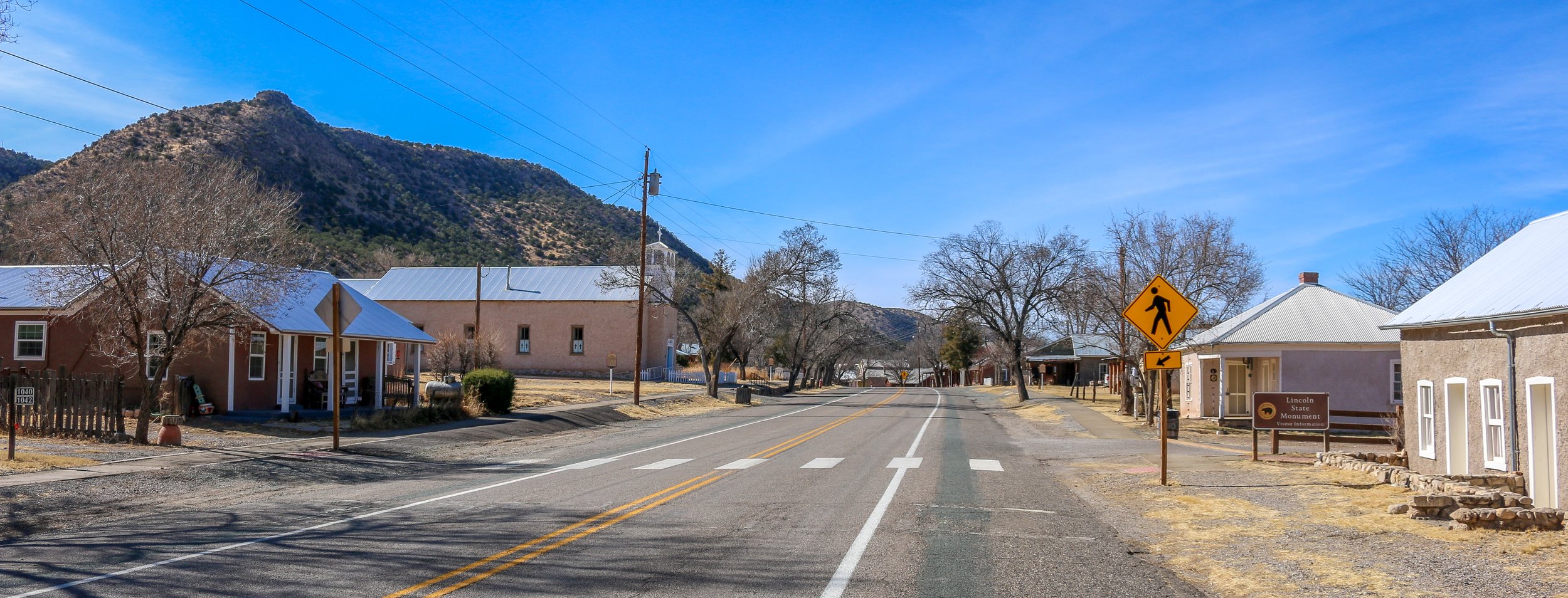
The area in southeast New Mexico that now includes the town of Lincoln was originally inhabited by Mogollon people and later by the Piros and Mescalero Apache. When a group of settlers arrived from the Rio Grande Valley, they named their new town La Placita del Rio Bonito, or “the place by the beautiful river”. The town was renamed soon after the Civil War in honor of President Lincoln and was made the county seat of the massive Lincoln County. In 1873, Irishman L.G. Murphy opened a general store and won the contract to supply beef to nearby Fort Stanton. When Englishman John Tunstall set up a rival store down the street and challenged Murphy’s monopoly on the beef contract, the Lincoln County War broke out with each man hiring his own army of gunslingers. One of Tunstall’s men, who the world remembers as Billy the Kid, has gone down in history as one of the most notorious figures from Old West lore. The Kid was arrested and tried for his role in the murder of the county’s sheriff and was held in the county courthouse, which had once been Murphy’s store, to await his hanging. He outsmarted and overpowered the two deputies who were watching him and escaped, only to be cornered and killed by the new sheriff, Pat Garrett, just a few months later at Fort Sumner. The volatility in Lincoln led President Rutherford B. Hayes to call the town’s main street "the most dangerous street in America". Today there are quite a few remnants from its wild past and much of the town is an historic site. I found the whole place fascinating and learned a lot while I was there. I wish I had had more time to explore it, but I hope you enjoy these photos from my brief stay in tiny Lincoln, New Mexico, once one of the Old West’s baddest towns.

Comment

Snapshots: Roswell - Alien City

Comment

Snapshots: Roswell - Alien City

Roswell is a town of about 48,000 people, making it the fifth largest city in New Mexico. The area was originally settled in 1869 when Van C. Smith and Aaron Wilburn built a small store, inn and post office. They named their settlement Roswell, which was Smith’s father’s first name. Roswell was the home of Walker Air Force Base from 1941-1967 and housed a POW camp during World War II, holding mostly German prisoners. In 1947, a UFO purportedly crashed in the area and the military seized the aircraft and its alien operators. This alleged incident has brought interest and controversy ever since, and you can read all about it and decide for yourself at the International UFO Museum and Research Center. Roswell has embraced the tourism opportunity from their UFO encounter and there are no shortage of T-shirts and bumper stickers to be had. Beyond that, I found Roswell to be a pleasant place full of kind and welcoming people and I’m definitely glad I stopped in for a while. I hope you enjoy these photos from fun and beautiful Roswell, New Mexico.

Comment

Snapshots: An Autumn Day in Red Wing, Minnesota

Comment

Snapshots: An Autumn Day in Red Wing, Minnesota

Red Wing was definitely one of the nicest towns I visited during my entire stay in Minnesota. It’s a beautiful historic city of about 16.000 right on the Mississippi River and the Great River Road. Before European settlement, this was Dakota territory and the town takes its name from Mdewakanton Dakota leader Tatankamani, whom Europeans referred to as “Red Wing”. As settlers came west, the Mississippi River was a major transportation corridor, and many people disembarked at Red Wing to begin their new lives on the frontier. A town sprang up and early industries included mills and tanneries. In 1905, Charles Beckman began crafting leather work shoes for the miners, loggers and farmers in the region, and Red Wing Shoes was born. Red Wing Shoes is still headquartered in the town and many of their brands are still produced there, contributing heavily to the local economy. Red Wing has some beautiful, historic architecture and many wonderful art displays around town. While I was there on an overcast, fall day I still found the city to be charming and extremely photogenic. It’s definitely a town I will return to in the future. I hope you enjoy these photos from beautiful Red Wing, Minnesota, an historic town on the banks of the mighty Mississippi River.

Comment

Snapshots: New Ulm - Minnesota's Most German Town

Comment

Snapshots: New Ulm - Minnesota's Most German Town

New Ulm is a mid-sized city which sits at the confluence of the Minnesota and Cottonwood Rivers in southern Minnesota. Founded by German-Americans, the town gets its name from the German city of Ulm in Bavaria. While not as over-the-top as Frankenmuth in Michigan, New Ulm has many German features to it and the longer you stick around the more you will see. I really enjoyed the Glockenspiel and the Hermann Monument and found several of the churches in town to be truly spectacular. The Historic Society Museum is housed in the eye-catching old post office, and even the fire hydrants brought a smile to my face. On the outskirts of town is the old A. Schell Brewery, which is definitely worth a stop. Founded in 1860, it’s Minnesota’s oldest brewery and one of the oldest in the country. Unlike most of the town, it was spared during the Dakota War of 1862 which devastated New Ulm. I had a wonderful German meal at the Ulmer Cafe and talked to some welcoming locals while I was in town. I hope you enjoy these photos from beautiful New Ulm, Minnesota’s Most German City.

Comment

This Week on the Road - November 3rd-10th

2 Comments

This Week on the Road - November 3rd-10th

Hello Everyone! When many of you will be reading this, Shadow Catcher and I will be celebrating the 4 year anniversary of this project. We set out together on November 11th, 2017 from our home base in Washington D.C. to Harpers Ferry, West Virginia. At the time, the plan was to spend a month in each of the 48 contiguous states, which, if done in one long stretch, would have put an end date right around now. I learned very quickly that a month isn’t very long when it comes to really getting to know a state and while I still try and move right along, six weeks seems like a more realistic timeframe. My dreams of financial success with this project have been all but a complete bust, so I have had to stop and go back to guiding to replenish my coffers. Thankfully, it’s a job I love and it’s fairly easy to put away money in a short time and keep going. And of course who could have predicted a global pandemic, which grounded us for 15 months at home? That time was a blessing as I got to spend it with my folks and watching young Mason every day on his journey from 2 to 3 years old. On the plus side, I’ve seen and done so much, learned more than I ever thought possible and met many truly wonderful people along the way. It’s been everything I hoped it would be and infinitely more and I’m grateful every day for this project, this journey, and all of you who have chosen to share in it. Like any journey, it’s had its ups and downs, but at the end of the day, I wouldn’t trade it for anything. As I wind up my time in Minnesota, my 16th of 48 states, that would leave me 1/3 of the way there. I don’t know if I’ll finish this project, but I’m definitely planning to keep going for the near future. Thank you all for coming along for the ride.

It’s been a very busy week blazing across the prairies of Southwest Minnesota. With daylight savings time ending and snow in the forecast, it is definitely time to start making an exit plan, but I didn’t want to miss out on a whole region. I’ve definitely driven more this week than I usually do and I’ve seen some pretty amazing places but it’s also been pretty fast and furious. That being said, I’ve driven past some fascinating things this week that either gave me pause or a good chuckle. When I drove through Brainerd again this week, I passed by the Warriors Early Childhood Learning Center. Their school team name is the Warriors, but to an outsider I thought this was pretty funny. I also drove past the towns of Nimrod, Sleepy Eye and Weetown – all of which made me smile. I saw a Sasquatch Reporting Station in Starbuck and a street called Oink Joint Rd. The Starbuck High School mascot is the Bucks, the Fergus Falls (county seat of Otter Tail County) is the Otters and of course in Pelican Rapids they went with… the Vikings! It was wonderful to see Amish buggies driving on the roads and tumbleweed tumbling down dusty city streets. It was a wonderful week of clear sunny days and I tried to make the most of it. Here’s what I got into:

When last I wrote I was headed clear across the state of Minnesota back to the western border. Along the way I stopped in the cute little town of Wadena to take some photos and have a wander. I ended up popping into the Little Round Still Distillery and talking with the nice folks there for a while. They gave me a lesson on Minnesota’s complicated liquor laws and it sounded like there is a lot to overcome when starting a brewery or distillery in the state. I ended up buying a 375ml bottle of their Gunflint whiskey which was quite good and the biggest bottle they could legally sell me. From Wadena, I headed on to the even smaller town of New York Mills to check out the Regional Cultural Center there. For a small town, this center is pretty well known and has a wonderful gallery and shop and hosts classes, workshops and events. There was a nice display of “wet felting” wall hangings by Kristen Anderson in the gallery when I was there which were beautiful and told an interesting story. There were also some other smaller pieces from previous exhibits upstairs. I was there for longer than I thought I would be but really enjoyed it. From there I headed on to Perham where I jumped on the Otter Trail Scenic Byway. This beautiful loop road took me through small towns and past some amazing prairie scenery as I made my way around Otter Tail County. I stopped in Pelican Rapids to take a photo of the world’s largest pelican and pulled into Phelps Mill right as the sun was setting to get some great photos of this historic mill now owned by the county. It was a great place to end my day and then I headed on to Fergus Falls for the night. I went downtown and found it pleasant but empty without a single bar or restaurant around. I really find it strange and sad when towns roll up their sidewalks after dark like that. I headed out of town and stopped for a quick beer at their brewery which was actually really tasty but way overpriced. I was sad that my only option for dinner at 8pm was Applebee’s which was on the low side of mediocre. For a town of 13,000 people I had expected a little more, but it was still a nice place to spend the night and it would redeem itself the following day.

2 Comments

This Week on the Road - October 21st-27th

2 Comments

This Week on the Road - October 21st-27th

Hello Everyone! It’s been a beautiful week out here in central Minnesota. The skies have been clear and blue and the lakes have been flat and calm. I’ve seen some beautiful small towns this week and spent a day in Itasca State Park, my favorite stop in the state so far. I’ve also had some company this week as I’ve caught up with the families of some old friends of mine which has been really wonderful. The fall colors have been hanging on pretty well for me and this week brought me into tamarack country – those beautiful pine-like trees which turn a beautiful orange this time of year before they drop their needles for the winter. A lot of sites and museums I wanted to see have been closed for the season which continues to be disappointing – especially those at the state level. In my opinion, any site you deem important enough to designate a State Historic Site should be open year-round. Most of these places are staffed by local volunteers anyway and I can’t imagine they wouldn’t make enough money to keep the lights and heat on. It just seems strange to me that these sites are closed the vast majority of the year. I did get into a couple of great museums this week, though, including the wonderful history museums in Grand Rapids and St. Cloud. I’ve also noticed this week that most public restrooms I’ve encountered in the north of the state don’t have locks on the doors to the stalls which seems very strange to me. Not that anyone has barged in on me while I was using one, but I’ve never really seen that as a rule anywhere else. Regardless, it’s been another interesting week on the road, so let’s get into it.

When I left you last week, I was in Moorhead on the Red River and the North Dakota border. After I finished up my newsletter, I headed over to Murphy’s Pub for a songwriters’ round which I really enjoyed. The four people playing that night, all local to the Fargo-Moorhead area, did a great job and I loved seeing some live local music. I woke up nice and early on Thursday morning and headed back to the Stave Church Replica at the Hjemkomst Center near the river. The sun was just coming up and while it was definitely cold out there, it was really beautiful at that time of day. I took a lot of photos and then had some breakfast and headed into the museum. I spent some time checking out the incredible Hjemkomst Viking Ship which is quite a sight to behold. It is a scale replica of an old Viking ship which was built by high school guidance counselor Robert Asp in the 1970s. His plan was to sail the ship to his ancestral homeland of Norway, and while he died in 1980 before he could make that journey, his children took up this dream and made the trip over the course of a month in 1982. It’s a phenomenally inspiring story all around and I loved seeing the ship and the video about the voyage. I also got a tour of the interior of the Stave Church which was also very cool. There were other exhibits in the museum as well, including one about the Native Ojibwe and Dakota People in the area and a “healing through art” exhibit of military veteran artwork. It was a wonderful morning and definitely one of the must-see places stops on any trip to Minnesota. From there, I headed back to the Sons of Norway Lodge since it was Pie Day and had a local specialty of Tater Tot hotdish (a mix of veggies and cream of something soup topped with Tater Tots and baked) and a slice of coconut cream pie. I hit the gym to try and work that off a little bit and then got on the road to Detroit Lakes, a beautiful little historic town on its namesake lake. The town used to be called Detroit, but too many postal errors caused them to add the “Lakes” part in the 1920s to help rectify the problem. It was a beautiful afternoon and I enjoyed wandering the downtown area and then strolling along the lakefront until sunset. The sunset was really beautiful that afternoon, and the beautiful clouds were perfectly reflected in the lake. I hadn’t planned on eating out that night, but the smell of pizza wafting from Zorba’s on the Lake drew me in. Their pizza was quite good and I washed it down with some local beer before calling it a night.

I was up early again the next morning and on my way to Itasca State Park further into the central part of the state. This is where I really started to see the orange tamarack trees which have been so phenomenal this week. I passed by some beautiful mirror-like lakes and got out and took some awesome photos (if I do say so myself). I pulled into the historic Douglas Lodge around 11am and took a nice 3 mile hike down the Deer Park Trail and back up the Ozawindib Trail. I also detoured to the Aiton Heights Fire Tower which had amazing views out over the park from the top. The hike took me through some beautiful forest and past several phenomenal lakes and was one of the better hikes I’ve made in a while. The day was a perfect day to be there and I really enjoyed this hike despite my knee still giving me some trouble from last week. I finished my hike, had some lunch and then headed to the highlight of the park – the headwaters of the mighty Mississippi River which begins its 2,552 mile journey to the Gulf of Mexico right there in central Minnesota. There was a pretty big crowd at the headwaters, waiting to take their photo with the sign and to walk across the rocks where the lake empties into the river. It’s probably about 15’ wide at that point and while you can’t quite jump across it (well maybe you can, but I certainly couldn’t), it was only about 8 stepping stones across. Seeing the Mississippi at its humble beginning was like visiting an old friend as a child – you know what they’re going to grow into and you can marvel at how small they once were. In the nearby museum I learned that the lake and the park took their name from combing the Latin words Veritas (truth) and Caput (head) which was coined by Henry Schoolcraft when his Ojibwe friends led him to the source of the great river. Others before and after claimed different sources, but this one seemed to be the “true head” to Schoolcraft and is generally agreed upon today. There are small creeks that feed into Lake Itasca, but none is really big enough to be considered a river.

2 Comments

This Week on the Road - October 6th-13th

Comment

This Week on the Road - October 6th-13th

Hello Everyone! It’s been another wonderful week out here on the road as I’ve traveled from the beautiful North Shore, up the Gunflint Trail and back and then out into the interior of the state. The weather has been very up and down with a lot of clouds and rain but also a few truly stunning days which has really showed this region in its best light. Because of the weather, I have been moving a little slower than usual because there are things I don’t want to miss in this region. I’ve also been trying to plan the rest of my time in the state which takes time to research and plot out. I am very grateful to all of my Minnesotan friends for making my first week here so easy – with all of their pointers on the region, I barely had to look at anything other than my map. As I get deeper into the state though, I’m more on my own – which is perfectly fine, but it means I want to be sure I have at least a rough plan so I’m not missing things I really want to see. I was also trying hard to get another podcast episode done this week which I finally finished yesterday (and you can find here). I really hoped to keep on top of my podcast better this summer, but I’ve just been so busy that I haven’t had the time I thought I would. My fun observations this week have included Minnesotan’s pronunciation of the word “sauna”, which is probably close to the Finnish pronunciation, as “sow-na”. In most of the country we pronounce it “saw-na”. There are actually signs posted and T-shirts to be bought about this pronunciation debate, which I find amusing (here’s an article discussing the pronunciation). I also saw a great sign this week about social distancing which told people to stay at least one canoe paddle apart (in Wisconsin it was one cow apart). How wonderful! I’m also loving the Halloween decorations that are springing up everywhere and the fresh apples and cider in the stores. The roads have been good this week and actually make driving much more pleasurable. I know this is in part due to less traffic and especially less truck traffic in the area, but I’ve still been enjoying it. I’ve also seen an eagle pretty much every day since I left Duluth which has been truly wonderful to see.

After I finished last week’s This Week, I did make it out to Devil’s Kettle Falls in Judge C.R. Magney State Park. I had seen a lot of waterfalls last week, but my friend Jen was insistent on my seeing this one in particular. I was glad I did, because it was really cool. There are two sides to the falls – one continues down the river and the other disappears underground. After hiking to the falls, I headed back into Grand Marais right as the weather was clearing and it turned into an absolutely beautiful day. I had fun wandering around town and out along the breakwater to the lighthouse, taking photos and enjoying the sunshine. There are some cool buildings and some beautiful views in Grand Marais (pronounced “muh-ray”), and I enjoyed my afternoon, but I also didn’t want to spend the whole day in town as I knew there was a rainy forecast ahead. My friend Tim had recommended a trip up the Gunflint Trail, once a logging road which was improved to allow firefighter access to in case of wildfire and is now a state scenic byway. The road stretches 40 miles into the interior of the state and has a lot of public access points to many of the lakes along the way. I bopped along and ended up at Gunflint Lake, 35 miles or so up the Trail, about an hour before sunset. I cast out my fishing line and sat at the end of the dock and watched the beautiful day fade to dusk as the sun set in the west. I went back to my van and cooked some dinner and when I had finished and came back down to the lake there were a million stars overhead. It was so dark out there and the massive lake allowed such an expansive view that I just stood there in awe, listening to the loons and watching the stars. It was pretty magical.

I set my alarm to go off early on Thursday morning so I could watch the sun come up over the lake. The water was very still and it was really quiet and I just sat on the end of the pier with my coffee and enjoyed the morning. After a nice breakfast, I continued on to Gull Lake at the end of the Gunflint Trail where I spent some time in the fascinating Chik-Wauk museum which is housed in what was once a tourist lodge. The museum had some great displays on the natural history of the area and on the development and evolution of the Gunflint Trail. There was also a preserved tourist cabin with a nice view over the lake and a wonderful building filled with historic canoes. When I left the museum, I moseyed back down the Trail, stopping off to do a little fishing at a couple of lakes along the way. I also did a hike out to Magnetic Rock which is a huge monolith in the middle of the forest. The rock itself was cool and worth the trek, but the trail was quiet and had some stunning views as well. After my hike, I made my way back to Grand Marais where I watched the sun set and enjoyed a couple of beers at the brewery and a delicious walleye sandwich at the Gunflint Tavern before calling it a night.

Comment