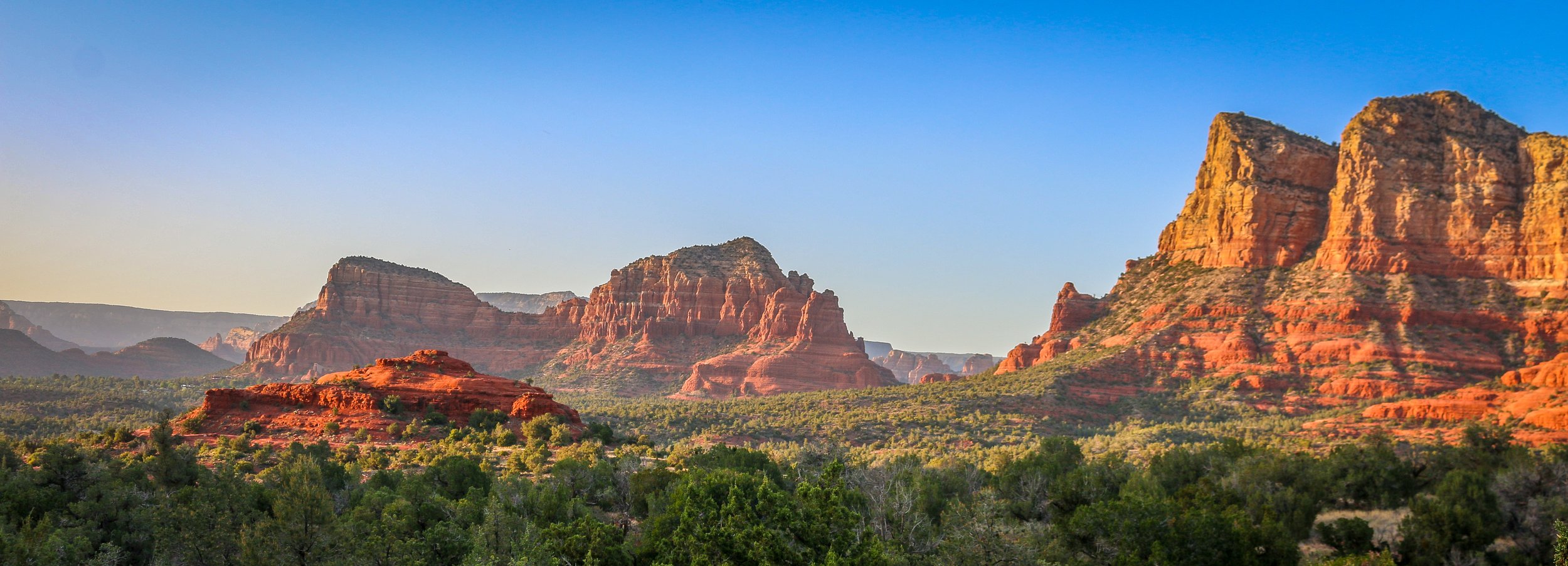
I had spent time in Sedona before, but never enough. I was always there for just a night, usually late in a tour where we didn’t have much time to do more than have a cursory look around. The cost and snobby attitudes of the locals with their spiritual vortex talk was always a turn-off for me. I had never had the chance to really get out there and do some hiking before, but I’m sure glad I scheduled a few days for it on this trip. I’ve been to a lot of places in this country, but few can compare to the red rock country surrounding Sedona. I don’t know about vortexes, but it is definitely a beautiful and magical place. Like most of red rock country, it’s best to hit the trail very early in the morning or just as the sun is starting to go down. While I was there, I hiked to the Birthing Cave, the Subway, Devil’s Bridge, the Courthouse and Bell and, my personal favorite, the Airport Loop. With the exception of this last one, which I had all to myself, there was no shortage of people in the area. It’s definitely not a secret place, nor is it off the beaten path, but it’s well worth it to visit and the shear number of trails in the area helps to disperse people pretty well. I had a wonderful few days in Sedona and will definitely be back. I hope you enjoy these photos from beautiful Sedona, Arizona, a true hikers’ paradise.
Organ Pipe Cactus National Monument was one of the top spots on my list of places to visit during my time in Arizona. It’s a remote park, located two hours from anywhere and right on the U.S./Mexican border, but it’s the only place in the country that you can find naturally occurring organ pipe cactus. In addition to these beauties, there are so many other species of cactus and desert plants as well which has led to this region also being named a part of UNESCO’s International Biosphere Reserve.
Organ Pipe Cactus was made a National Monument by Franklin Roosevelt back in 1937. A special act was passed to allow mining in the area during World War II, an act which sadly wasn’t repealed until 1976. The park’s remote location on the Mexican border used to bring both drug runners and human smugglers through the area, making this America’s most dangerous park. This danger is memorialized in the Kris Eggle Visitors Center which was named for a park ranger who was killed protecting visitors from drug smugglers in 2002. In the wake of his death, the border was reinforced and I felt safe there during my stay.
It was unbelievably hot when I arrived on an afternoon in late April. So hot that I couldn’t actually do anything but hover in the shade of the restroom and wait until the sun started to go down. I did enjoy a wonderful evening hike and an early morning one the following day as well. The area is beautiful and it was great to see the Organ Pipes in their native habitat. It was definitely just a one night stop, but I’m very glad I went. I hope you enjoy these photos from Organ Pipe Cactus National Monument.
There may be no more iconic plant in the United States than the stately and stoic saguaro cactus. These beautiful cacti can grow up to 40’ tall and live to be 150 years old. They won’t start growing arms until they are 75 years old and some will grow many arms in their lives. Most of the natural habitat of the saguaro is in the Sonoran Desert which straddles the U.S./Mexico border.
In 1933, President Herbert Hoover designated Saguaro National Monument which we now call the Rincon Mountain District of the park. In 1961, John F. Kennedy added the Tucson Mountain District to the Monument and in 1994 these two tracts were combined into Saguaro National Park.
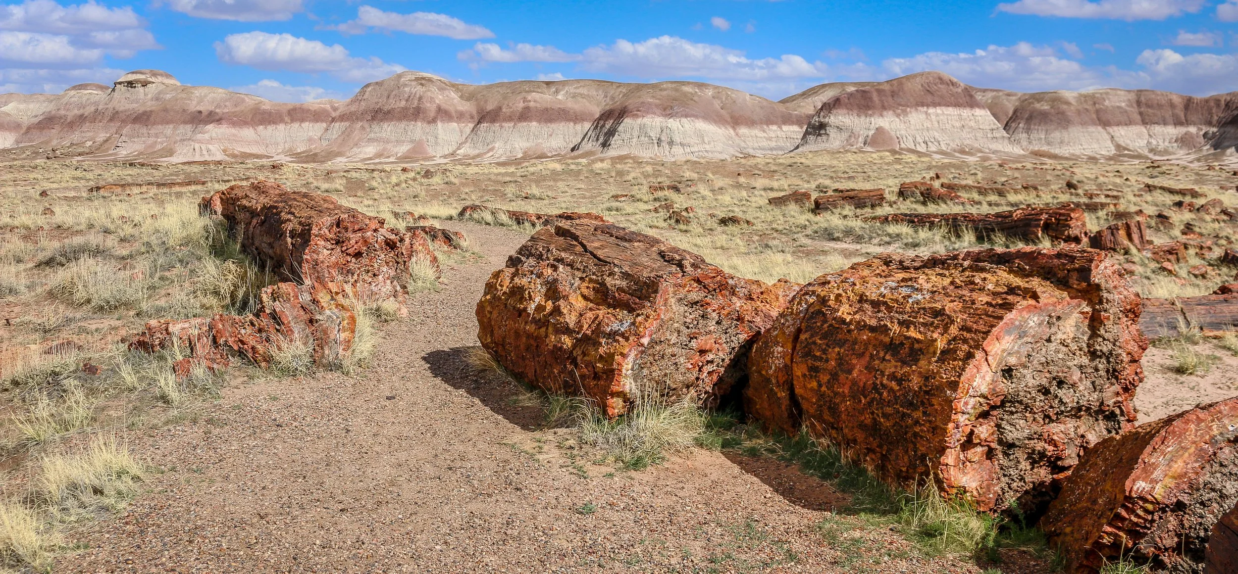
Petrified Forest National Park in eastern Arizona contains a beautiful collection of petrified wood and also includes the Painted Desert, Blue Mounds and an old stretch of Route 66. It’s a park best explored by car, but you won’t really appreciate it unless you get out and hike out into the wilderness. Petrified Forest was designated a National Monument back in 1906 and was upgraded to a National Park in 1962. I enjoyed my visit to the park and hope you enjoy these photos I took exploring the Petrified Forest.
I’ve spent many months of my life on the Navajo Reservation, more than I’ve spent with any other Native American group. I’ve always found the Navajo People (or the Diné as they refer to themselves) to be warm and welcoming with a wonderful sense of humor. I’ve had the incredible opportunity to lead tours throughout the Navajo lands and to explore on my own as well. Some of these photos are from my recent travels on the Rez and some are old favorites. I hope they show the diversity of the landscape and the splendor of my time in Navajo Country.
Rio Grande del Norte is one of our more recent National Monuments, having been designated as such in 2013. It protects the confluence of the Red River and the Rio Grande which are both designated Wild and Scenic Rivers. Both gorges are gorgeous and the point of land above the confluence, called simply El Punto, provides amazing views from high above the two rivers. I hiked the Little Arsenic Trail while I was there, which brought me down to the Rio Grande and led me straight to the confluence. It was one of the better hikes I did during my stay in New Mexico and was very rewarding around every turn. I spent the night at the campground on the canyon rim and enjoyed a beautiful sunset in the evening and a magical sunrise the following morning. In between, the stars were spectacular. I debated whether to drive out to this park as it was somewhat out of the way, but I’m sure glad I did as it is stunning from end to end. If you’re ever in the area, you should as well. I hope you enjoy these photos from beautiful Rio Grande del Norte National Monument.
Organ Mountains - Desert Peaks National Monument is a beautiful park in Southeast New Mexico managed by the Bureau of Land Management. Just 25 minutes from Las Cruces, this park makes for a great day trip from the city or a stop-off on your way to or from White Sands National Park. I enjoyed a wonderful 7 mile round-trip hike up to Baylor Pass, a saddle with wonderful views out over the Chihuahuan Desert. In the afternoon, I made a 3 mile round-trip hike to the ruins at Dripping Springs. This area, which contains a natural spring deep in a hollow, was once home to Boyd’s Sanitarium and Van Patton’s Mountain Camp. The sanitarium catered to tuberculosis patients while the mountain camp was a fancy hotel and resort. Opened in 1897, the hotel had 15 guest rooms, a dining hall, a concert hall, a gazebo and a roller-skating rink and hosted the likes of Pat Garrett and Pancho Villa. The resort fell on hard times during World War I and Eugene Van Patten sold it to Dr. Boyd who ran the sanitarium. The Great Depression would be the final blow to the resort and it closed for good in the 1920s. Today it is maintained in a state of arrested decay and makes for a cool walk in the late afternoon. There is so much more to this park than just these two hikes, but they were all I had time for during my visit. I hope you enjoy these photos from Organ Mountains - Dripping Springs National Monument.
Magnificent White Sands National Park in central New Mexico preserves the largest gypsum dune field of its kind in the world. This dune field in the heart of the Tularosa Basin covers 145,762 acres and includes 4.5 billion tons of gypsum sand. This gypsum was left in the area after the Permean Sea retreated several million years ago, and water and wind shape the dunes we find there today. The dunes are ever changing, though, so you will never see the same landscapes on any two visits to the park.
People have been coming through the area for at least 11,000 years and we believe that a group we call the Jornada Mogollon were the first to farm the area (see my photos of their nearby petroglyph site here). Groups of Apache made their way into the area in the 1600s and European-Americans arrived in the 1800s. White Sands National Monument was created by Herbert Hoover in 1933 and it was made a National Park in 2019.
I arrived for my visit to the park just after dawn. The mountains to the east block the sunrise, but the skies were blue and full of amazing white clouds. I headed straight out to the heart of the dunes and hiked the wonderful 5 mile Alkali Flats Trail. The sun reflected brightly off the white sand making photography difficult, but I was grateful that there was no wind. In the late afternoon I set out to capture some of the beautiful plant life in the park, mainly different kinds of yucca, which contrast nicely with the white sand. I stayed to watch the sunset and found real peace and solitude out in the middle of the park. It was a wonderful day in White Sands National Park. You can find some of these photos for sale in my store , but please contact me if the one you want isn’t there and I’ll be happy to add it. I hope you enjoy these photos from my time in White Sands National Park.
Lake Itasca State Park spans over 32,000 acres in North-Central Minnesota. Native Americans have hunted in this region for thousands of years. In more recent times the area was inhabited by semi-nomadic bands of Ojibwe and played a roll in the fur trade. In 1832 an Ojibwe leader and guide named Ozawindib guided explorer Henry Schoolcraft to the lake they called Omashkoozo-zaaga'igan (Elk Lake), where he showed Schoolcraft the headwaters of the Mississippi River. Schoolcraft chose a new name for the lake by combining the Latin words Veritas (truth) and Caput (head) to form ‘Itasca’ honoring the ‘true head’ of the Mississippi. A monument has been placed there marking the beginning of the river’s 2,552 mile run to the Gulf of Mexico and is one of the more iconic photos in the state. The park is so much more than just the headwaters though, with dozens of miles of trails, the historic Douglas Lodge, campgrounds, lakes and even a climbable fire tower. The area is so wonderful, in fact, that Minnesota declared it a state park in 1891 making it the oldest state park in the state and one of the oldest in the country. I had a wonderful day in Itasca State Park and found it one of the prettiest places I’ve seen in Minnesota. I hope you enjoy these photos from lovely Itasca State Park, a real gem in the heart of the state.
Minnesota’s North Shore stretches along Lake Superior from Duluth all the way to the Canadian border. This region was at the top of all of my Minnesotan friends’ must-see lists and after five days of exploring, I certainly understand why. There are eight beautiful state parks along this stretch, as well as Grand Portage National Monument which is a cooperative effort between the National Park Service and the Grand Portage Band of Lake Superior Chippewa. This park tells the story of the early fur traders, voyageurs and Native Americans who came together on the western shore of Lake Superior. Waterfalls abound along the North Shore, including Minnesota’s tallest - High Falls in Grand Portage State Park. I also found lighthouses, cute little lakeside towns and breathtaking views out over Lake Superior. Also in this region is the wonderful Gunflint Trail Scenic Byway which stretches 40 miles, from Grand Marais to Gull Lake, and offers wonderful lodging and recreation activities in the state’s Boundary Waters Canoe Area. While not technically on the North Shore, I’ve included some of my favorite shots from my two days along this beautiful road as well. I so enjoyed watching the sun set and then rise again in the morning over Gunflint Lake, and the stars at night were simply amazing. I will echo my friends’ recommendation - if you’re coming to Minnesota, the North Shore is definitely a place you must see. For such a compact area, it’s one of the most beautiful regions I’ve seen in my travels anywhere in the country. I hope you enjoy these photos from Minnesota’s North Shore and the Gunflint Trail Scenic Byway.
Apostle Islands National Lakeshore is a beautiful park which stretches along Wisconsin’s Lake Superior coastline. The park extends over 21 of the 22 islands in the area with only Madeline Island being outside its boundary. In addition to the islands themselves, the park extends to the historic fishing area at Little Sand Bay and the beautiful coastline and sea caves at Myers Beach. Nobody is quite sure who gave the islands their names, but French maps referred to them as the Apostle Islands as early as the 1700s. The National Lakeshore was established in 1970, having been proposed by Wisconsin’s Senator Gaylord Nelson who is also considered the founder of Earth Day.
During my time in the park, I enjoyed a scenic cruise around the islands with Apostle Island Cruises. Our 2.5 hour journey took us around most of the islands with special attention paid to the beautiful, outer Devil’s Island and the historic lighthouse at Raspberry Island. Unfortunately, the islands were closed to camping during my stay so I wasn’t able to spend the night out there which I really would have enjoyed. Beyond the cruise, I spent some time learning about the history of the area at the outdoor museum at Little Sand Bay (which was also a wonderful place to watch the sunset). There were also recorded stories from rangers, historians and Native Americans in this section to listen to. On my last morning in the park I visited the Myers Beach section to hike the Lakeshore Trail to The Bowl to view the amazing sea caves and beautiful coastline. I was also pleasantly surprised by the number and variety of mushrooms I experienced along this trail. I had a wonderful visit to the Apostle Islands and hope you enjoy these photos from my stay.
The Driftless Region of Wisconsin is the area below the furthest advance of the glaciers during the last Ice Age and covers most of the southwest portion of the state.. It is home to wonderful, ancient sandstone formations, beautiful parks and great little towns. This area is definitely hillier than much of the rest of the state and ends (at least as far as Wisconsin is concerned) at the Mississippi River on its western border. I had a great time exploring the Driftless, boating through the Wisconsin Dells, walking the State Park trails, driving the Great River Road and exploring the towns I found along the way. I encountered many different European-American traditions along the way including two of Wisconsin’s most famous: beer and cheese. I visited Wisconsin’s first Capital at Belmont, it’s biggest tourist attraction at House on the Rock and some of the state’s mining history at Mineral Point The Driftless is a sprawling region with a diverse culture and a fascinating history. I hope you enjoy these photos from Wisconsin’s Driftless Region, a unique place which I really enjoyed visiting.