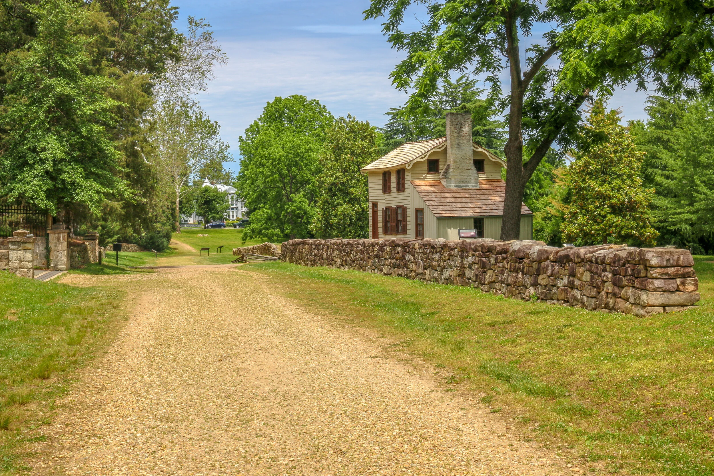
Vitus Bering claimed Alaska for the Russian Empire in 1741 under orders from Tsar Peter the Great. Russia’s hold on Alaska would last until they sold the territory to the United States in 1867 and their primary focus was on the abundance of valuable furs found in Alaskan waters. The most enduring legacy of Russian culture in Alaska is the strong presence maintained by the Russian Orthodox Church in the state. This summer I had the pleasure to visit these four beautiful Russian Orthodox churches, three in the Kenai Peninsula and one in Anchorage. As someone born into and raised in the Russian Orthodox faith, I found it fascinating to visit these churches and I was thrilled (or, perhaps, blessed) to see them all on sunny days. I hope you enjoy my photos.
Most of the states I’ve been to seem to have a town like Solvang - a place with solid European roots that has developed into a tourism draw over the years. Some of my favorites have been Helen, Georgia, Frankenmuth, Michigan, New Ulm, Minnesota and Helvetia, West Virginia. All of these have had either a German or Swiss background, which made the Danish village of Solvang different and quite fun for me to explore.
The area where Solvang now stands was originally Chumash land. In 1804, the Spanish built Mission Santa Inés, one of 21 Catholic missions they would establish in Alta California to try and convert the native peoples and help the Spanish claim to the territory. After Mexico won its independence in 1821, the mission system was dissolved and the land was divided into land grants and this area became part of Rancho San Carlos de Jonata.
Beginning in 1850, many Danish immigrants began arriving on America’s shores including some of my ancestors on my father’s side. Communities would begin to form, especially in the Midwest. In 1910, a small group of Danish men decided to try somewhere a little warmer and purchased land in the Santa Inés Valley. A year later, a town plan had been drawn up and Solvang was born.
Originally, the town looked like many others in the region but after World War II many buildings were built or rebuilt in a more Scandinavian style. Today, Solvang is definitely an eye-catching place, especially the windmills which are scattered around the town. Tourism is a major draw with people coming from all over the world to visit the delicious bakeries and restaurants.
I had a great time in Solvang. It was busy but not crazy and I couldn’t help but smile as I wandered around taking these photos. It felt familiar yet different at the same time and it is definitely worth a visit if you’re looking for a break from the coastal beach towns and Mission architecture. I hope you enjoy these photos from beautiful Solvang, California’s Danish capital.
The area that is now Tucumcari was once home to dinosaurs who walked the shores of an inland sea. When the water receded, the sediment formed into sandstone and one of the formations it left is now called Tucumcari Mountain (although it’s really more of a mesa). Prehistoric people tracked mammoths and mastodons in the area and later developed farming techniques and built villages. In the 18th century, the Apache and Comanche moved through the area, hunting bison and pronghorn. The name, Tucumcari, comes from an Apache word “tukanukaru,” meaning “to lie in wait for something to approach”. In the early 20th century, the Chicago, Rock Island and Union Pacific Railroad was making its way across the country and a tent city sprung up called Ragtown and, later, Six Shooter Siding. As the camp grew into a town, they changed the name to Tucumcari and it stuck. Route 66 came through in 1926 and the town became an overnight stop for people headed west. Signs for miles declared “Tucumcari Tonight” and people pushed through for the promise of a hot meal and a comfortable bed. Tucumcari today still capitalizes on nostalgia for the “Mother Road”, but also has a wonderful museum downtown which has a place for everything and everything has been lovingly put into place. I had a great stop in Tucumcari and definitely got my kicks on Route 66. I hope you enjoy these photos from beautiful Tucumcari, New Mexico.
Native Americans have been passing through the area we now call the Salinas Valley for thousands of years. As agricultural techniques developed, hunter-gatherer societies began to settle down, plant crops and build permanent communities. The communities which grew in the Salinas Valley combined the traditions of the people we call Mogollon with those of the Ancestral Puebloans. They traded with other Puebloan groups to the west and with the Plains Indians to their east.
When the Spanish arrived in 1540, Coronado was searching for the 7 Lost Cities of Gold. He never found gold, but found abundant salt deposits in these mountains which is where they get their name (“salinas” means “salt” in Spanish). While the treasure seekers were met with disappointment, the Franciscan priests who accompanied them found whole towns of souls they believed needed saving. They took up residence in these remote pueblos and oversaw the construction of massive churches. They brought with them items which changed these societies for the better like wheat, fruit, cattle, goats and sheep. They also brought disease and demands for the Native people to give up their rituals and traditions. Some of these pueblos contain kivas, the underground centers of Pueblo communities and religion which point to some level of compromise, since later missions had kivas filled in and destroyed. Spanish priests and governors were often in disagreement over how to treat the Puebloan people, and cultural conflicts would often erupt…
I felt truly privileged to experience Cultural Days with the Red Cliff Band of Lake Superior Chippewa on their Reservation on the shores of Lake Superior. It was a beautiful day to celebrate their culture. In addition to all of the dancing, chanting and beautiful regalia pictured here, there were also stations set up to learn more about the culture of the Anishinaabe people. I helped render down bear fat and learned about its healing qualities, drank cedar and wintergreen tea and ate smoked fish, fried walleye and bear cracklins. I also learned about birch-bark basket making, heard some wonderful flute and drum music and watched some traditional gambling games. My favorite experience of the day was throwing a spear using an atlatl which is something I had only ever seen in museums before. I have been very fortunate in my life to have experienced Native American culture in several different parts of the country, and to be able to attend a festival like this one is truly special. The people of the Red Cliff Band were particularly welcoming and really helped me understand their culture better for which I am forever grateful. They even got me to join in on several of their spot dances which was just wonderful. It’s a different experience to be inside the circle looking out than outside the circle looking in. I hope you enjoy these photos which will give you a glimpse into the magic of the day.
I love a good carnival, but all of the fairs and festivals in my life have been compared to the Wisconsin State Fair, the fair of my childhood. My dad is from Milwaukee and every year when I was a kid he would take my brother and I home to see our grandparents and every year he would make sure we went when the State Fair was in full swing. I was very happy to find that over 30 years later it was pretty much still how I remembered it. I used to say “one of these days I’ll make it back to the Wisconsin State Fair”, and finally “one of those days” was realized. I had a great time and hope you enjoy these just-for-fun photos of the Wisconsin State Fair.
The Keweenaw Peninsula juts north from Michigan’s Upper Peninsula far out into Lake Superior. The word “Keweenaw” comes from an old Ojibwa word meaning “a place where portage is made”. This area is home to one of the richest copper deposits in the world and has been mined for thousands of years. After Michigan became a state in 1837, prospectors started making their way into the Keweenaw and copper claims and mines were quickly established. These mines were often in operation until World War II. Around these mines, communities grew which were often settled by immigrants eager to build a life in the new world. Mining was dangerous work, but the promise of a decent wage was enough to lure people to this isolated northern region. When the price of copper dropped and the mining process was no longer profitable, whole communities packed up and moved elsewhere and once-bustling towns were quickly reclaimed by the forest. Some towns remain today, but many are struggling and reliant on tourism. I loved this region and spent a little over a week exploring its history and towns. I toured the Quincy Mine and enjoyed wandering around Houghton, Hancock, Calumet, Eagle River and Copper Harbor. I included a few photos from nearby Marquette as well since it traces its roots to the same time period. The whole region is now a part of Keweenaw National Historical Park and Keweenaw National Heritage Area and you can find the Visitors Center in downtown Calumet. I hope you enjoy these photos from the beautiful Keweenaw Peninsula, Michigan’s Copper Country.
Battle Creek was home to the Potawatomi people long before white settlers arrived in the 1820s. The completion of the Erie Canal brought a wave of people into Michigan seeking work in the lumber industry and the town of Battle Creek was formally established in 1839. During the antebellum period, Battle Creek served as a minor but frequent stop on the Underground Railroad and in 1857 abolitionist Sojourner Truth chose it as her new home where she would live until her death in 1883. In the late 19th Century, the Battle Creek Sanitarium opened as a health resort for the rich and famous. Some of its more famous guests were President Warren G. Harding, Mary Todd Lincoln, Thomas Edison, Amelia Earhart and Henry Ford. The manager of the Sanitarium was Dr. John Harvey Kellogg whose brother William also worked there. I’ve read several accounts of how they accidentally created their now-famous corn flakes, but however it happened, they were a hit. A lesser known guest at the Sanitarium, C.W. Post, took the cereal idea and ran with it, setting up his own Post Cereal empire in Battle Creek. Between Post and Kellogg’s, Battle Creek has taken the nickname Breakfast Capital of the World, or, less seriously, Cereal City. Because these two successful brands still call Battle Creek home, the city looks great. The downtown area is vibrant and full of unique artistic flourishes and beautiful murals. There is a wonderful walking path along Battle Creek River and some great bars and restaurants around as well. Although it was quiet when I was there, I really enjoyed my visit to Battle Creek and I hope you enjoy these photos from Cereal City.
From 2010-2012, I lived and worked in a tiny fishing village in Southern Japan. My town, Usuki, had a beautiful historic core, a lovely industrial waterfront, an old castle ruin and some wonderful restaurants. In the two years I was there, we even got a 7-11 and a McDonalds. I lived in a beautiful, old, to-big-for-me apartment a few blocks from the water. During the week, I taught English in rural Japanese public schools. I worked in three different Junior High Schools and seven Elementary Schools. It was tough to move around so much, but I did enjoy the variety of it. Sadly, many of my days I spent very few hours in the classroom and was absolutely bored to tears most of the time. On the weekends I would spend time with friends or traveling the countryside. Our little corner of Japan was very rural, but also beautiful - especially when the rice was being planted. I found small communities to join, like a dance class in my town and a scuba diving shop in the next town up. I went to the beach and climbed mountains and visited the major cities. I also bought my first DSLR camera - at a pawn shop about an hour from my apartment. I didn’t learn to use it very well when I was there, but I took my first steps into the world of digital photography. It was also in Japan that I conceived the idea for this project and began to work to build this website. I made some wonderful friends while I was there, one of whom recently asked me if I had any photos of Japan that she could use to build a website for her business. That had me do a deep dive into my photo archives and dig up these old pictures. Some of them are actually pretty good, so I thought I would share them, and this story, with you here. Sadly, after a decade, I don’t remember where many of them were taken so not many of them are captioned. But I hope they can give you a feel for the time I spent there and some of the beauty of the country. Enjoy!
Last week I decided I wanted to check out a little bit of history and a little bit of seascape as well. It’s the middle of summer and I miss the beach but I’m not heading to the crowded Atlantic beaches right now. So I settled on a Chesapeake Bay view from the western shore towns of North Beach and Chesapeake Beach, only about an hour from Washington D.C. at a straight shot. I also wanted to take some photos at the beautiful Maryland State Capitol Building and wander around Annapolis’ Historic District as well. Connecting these two is Maryland’s Roots and Tides Scenic Byway.
Obviously, some of the key highlights of the journey were closed due to the pandemic, but I still enjoyed a little meander through the countryside, and the beach communities I ended up at sated my need for a little bit of time on the water. It’s definitely good to be out exploring, and I really enjoyed the Roots and Tides Scenic Byway. I hope you enjoy the photos I took along the way…
After being turned back south after the Battle of Antietam, Confederate General Robert E. Lee marched his army back to Virginia. Union General George McClellan was replaced by General Ambrose Burnside to command the Army of the Potomac, and President Lincoln urged Burnside to pursue the Army of Northern Virginia deep into the state and attack the Confederate Capital at Richmond. The major obstacle lying in their way was the Rappahannock River.
Burnside arrived at Stafford Heights overlooking the river and the small town of Fredericksburg in mid-November, 1862. He had sent orders to have pontoons at the ready to provide a means of bringing his army rapidly across the river. Tragically for Burnside and his men, the pontoons didn’t arrive for several weeks. Instead of crossing the river in boats or rafts, he chose to wait for the pontoons. By the time they got there, Confederate troops had dug in on the high ground south of the city called Marye’s Heights and behind a stone wall along a sunken road to the front of this position.
Union engineers worked through the night of December 10th to assemble the pontoon bridge, but their progress was slowed by Mississippi sharpshooters in town. A small group of Union soldiers crossed the river in boats and fought a battle to secure the streets of the town. They finally secured the town in late afternoon on the 11th, but it was winter and the daylight soon gave out. The bridge would be completed and most of the army would cross it on December 12th.
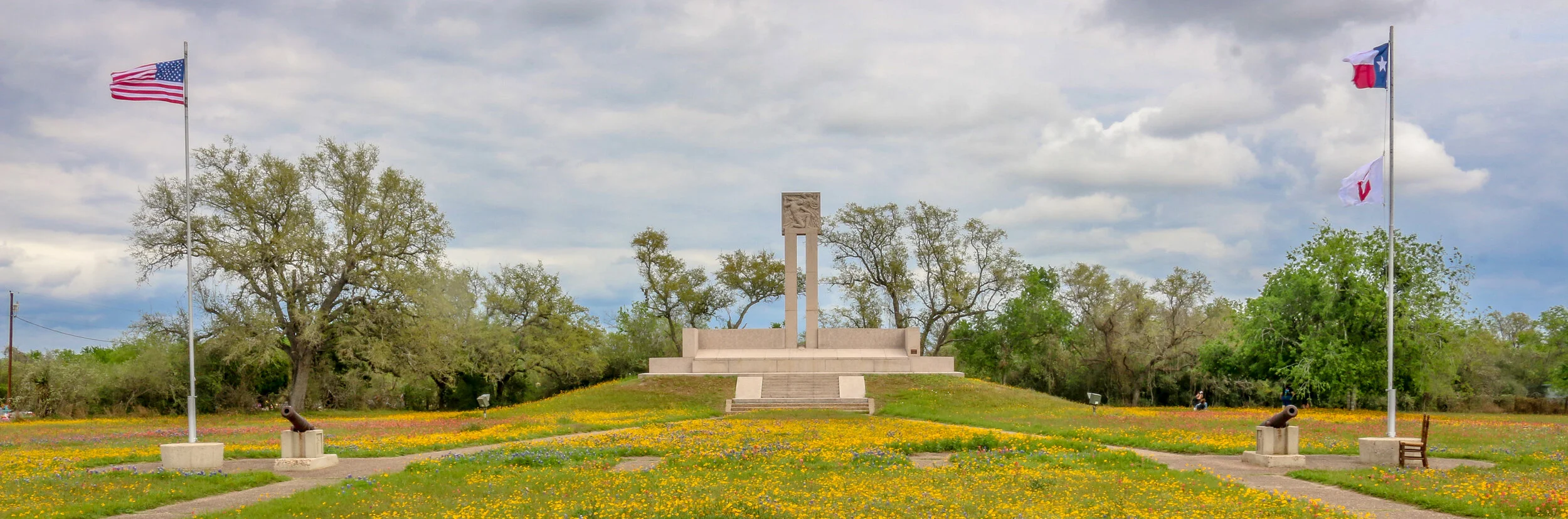
Like many towns in America with Spanish Colonial roots, Goliad started out as a presidio (fort) and mission, both located on the San Antonio River. Presidio La Bahia and Mission Nuestra Señora del Espíritu Santo de Zúñiga had originally been located elsewhere, but were moved to their current location in 1749. One of the first schools in Texas was founded nearby in 1804. During the Mexican War for Independence, the presidio was a strategic target and changed hands between the Spanish loyalists and Mexican rebels several times. In 1829 La Bahia, the village which had grown up near the fort, changed its name to Goliad, an anagram of the name Hidalgo (minus the “H”) in honor of Father Miguel Hidalgo, a hero of the Mexican Revolution.
In the opening days of the Texas Revolution, American mercenaries captured the fort and held it for six months. It was within the fort’s walls that the first Texas Declaration of Independence was signed. In March of 1836, the American garrison, under the command of Colonel James Fannin, was defeated at the nearby Battle of Coleto. Under the agreement that they would be treated as prisoners of war, they surrendered and were marched back to the fort. A week later, on Palm Sunday, under the orders of Mexican President Antonio Lopez de Santa Anna, 342 of these men, including James Fannin, were marched out of the fort and executed. Just over three weeks after the massacre, at the decisive battle at San Jacinto, Sam Houston rallied his troops with cries of “Remember the Alamo, Remember Goliad” as he led his rebel army on to victory and Texas independence…