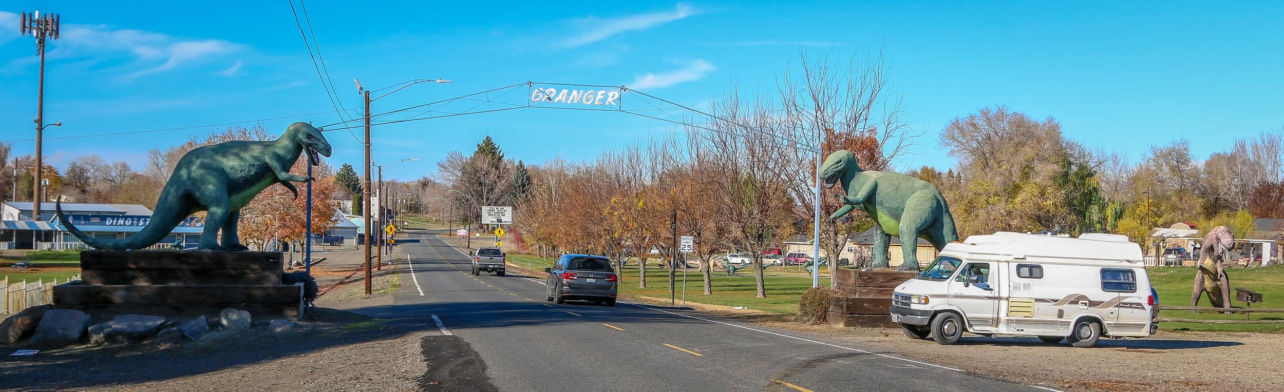
Because when you’re driving in the middle of nowhere and you look to your left and see dozens of dinosaurs roaming through a little town, you just have to stop and take a look. When you’re 100% sure that they’re not moving, you can get out and take some photos. Granger installed its first dinosaur statue in the 1990s in an effort to attract tourism (keeping in mind that Jurassic Park came out in 1993). There are now over 30 dinosaurs around town and Granger hosts their annual DIno-Days each June. I thought it was a fantastic little town and definitely worth a stop. I hope you enjoy these photos from Granger, Washington - The City Where Dinosaurs Roam.
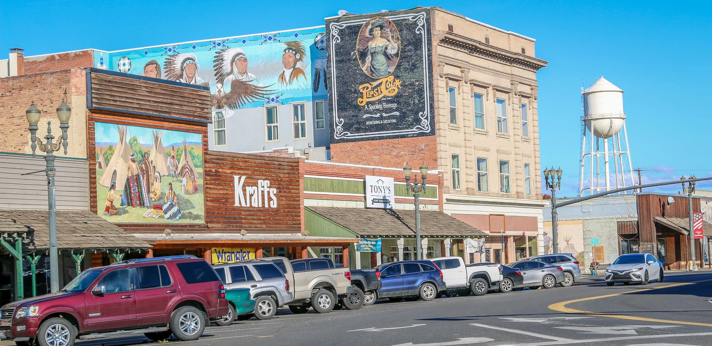
Toppenish is a cute little town with an Old West feel on the Yakama Indian Reservation in Southeast Washington State. It’s home to the wonderful Yakama Nation Cultural Center which was one of the better American Indian museums I’ve visited in the state. You can also find the Northern Pacific Railway Museum and the American Hop Museum which cover two of the main industries in the town’s history (both were sadly closed during my visit). Toppenish gets its name from a Yakama word meaning “landslide”. It is probably most famous for its 75 downtown murals which depict life in the valley between 1840 and 1940. I had a pleasant stay in Toppenish, and was treated to one of the best sunsets I’d seen in months while I was there. I hope you enjoy these photos from Toppenish, a town of museums and murals in Yakima County.
Breathtaking beaches, glacier covered mountains and incredible temperate rainforests all wrapped up in one amazing National Park? You must be talking about Olympic. Designates as Mount Olympus National Monument by Theodore Roosevelt, the area officially became Olympic National Park in 1938. Covering a massive 1442 square miles, the National Park covers most of Washington State’s Olympic Peninsula. 95% of the park is designated wilderness, meaning you’re going to have to hike in if you want to really see it.
I have been to Olympic before, but really just to catch the highlights at the Hoh Rainforest, Second Beach, Crescent Lake and Marymere Falls. On this trip I spent almost two weeks in the area and saw so much more of what the park had to offer. I did a four day, three night backpacking trip up the Hoh River Trail to Glacier Meadows and then a three day, two night hike around the High Divide/Seven Lakes Basin Loop, both of which were spectacular. I also visited the Quilault Rainforest, Ruby Beach, and Sol Duc Falls while I was there and stopped into the beautiful park lodges at Quinault Lake and Crescent Lake. The highlight for me was definitely the namesake Mount Olympus, but the quiet nights, the sound of water and the incredible wildlife also made me happy. I hope you enjoy these photos of the magical region of Olympic National Park.
Vitus Bering claimed Alaska for the Russian Empire in 1741 under orders from Tsar Peter the Great. Russia’s hold on Alaska would last until they sold the territory to the United States in 1867 and their primary focus was on the abundance of valuable furs found in Alaskan waters. The most enduring legacy of Russian culture in Alaska is the strong presence maintained by the Russian Orthodox Church in the state. This summer I had the pleasure to visit these four beautiful Russian Orthodox churches, three in the Kenai Peninsula and one in Anchorage. As someone born into and raised in the Russian Orthodox faith, I found it fascinating to visit these churches and I was thrilled (or, perhaps, blessed) to see them all on sunny days. I hope you enjoy my photos.
The area that is now Wickenburg was once Yavapai Indian land and the river that runs through it is the Hassayampa which means “following the water as far as it goes” in the Yavapai language. In 1863, German prospector Henry Wickenburg came to the area in search of gold. He found it and opened the Vulture Mine which would eventually produce 340,000 ounces of gold and 260,000 ounces of silver.
Ranchers came to the area as well and soon a community sprang up. In 1895, the railroad came through Wickenburg which spawned even more growth. The town was incorporated in 1909, making Wickenburg the oldest Arizona town north of Tucson and the 5th oldest in the state. In 1866, Wickenburg missed being named the territorial capital by just two votes.
Today Wickenburg is a quaint little community with a real wild west feel to it (some of the light posts are even wearing cowboy hats). There are some amazing art installations around town and the Desert Caballeros Western Museum is one of the best in the state. I love the design of the Saguaro Theatre which was also probably my favorite theatre in Arizona. You’re never alone when you’re in Wickenburg as life-like statues are spread throughout town making for a family friendly feel. I hadn’t planned on staying long in Wickenburg, but it’s a great town worth exploring and I was there way longer than I expected to be. Next time you’re in this part of Arizona, stop in for a spell. You’ll be glad you did. I hope you enjoy these photos from tiny Wickenburg - the Dude Ranch Capital of the World.
The area around what’s now Patagonia, Arizona was once a Tohono O’odham village called Sonoitac. It may take its current name from the southern region of South America, christened by Welsh miners who had moved north for work. Another theory is that early settlers found a large footprint, perhaps from a grizzly bear (or Sasquatch himself), and called it “Land of the Bigfeet”. However it got its name, Patagonia is a wonderful little town that’s big on art and seems to have sought to beautify even the smallest details of their town.
When the Spanish moved north into the area, they established the Mission Los Reyes de Sonoitac. The region became part of the United States through the Gadsden Purchase of 1853 and lead and silver mines were quickly opened. Fort Buchanan was established to provide protection for the settlers from Apache raiders, later to be joined by Forts Crittenden and Huachuca.
Father Eusebio Francisco Kino established the Mission San Cayetano de Tumacácori on the east side of the Santa Cruz River in January of 1691, making this the oldest mission site in what is now Arizona. The name “Tumacácori” is an English bastardization of a Spanish interpretation of an O’odham (Pima) word, the meaning of which has been lost. It is how the native people referred to this region. After years of violence at the hands of the Spanish, the O’odham people rose up in the Pima Revolt of 1751. Laying blame on the abuse of the Jesuits missionaries, they were pardoned by the colonial governor and the Jesuits would be expelled from the colonies beginning in 1757. The mission was moved across the river and renamed Mission San José de Tumacácori and the first actual church was built on this new site.
Franciscans would try and pick up where the Jesuits left off and in 1800 they began work on an ambitious new church, trying to match the majesty of Mission San Xavier del Bac to the north (a photo of which appears at the very bottom of this post). The church was never fully completed as the missions were closed when the Mexicans won their independence in 1821. Today, the mission is a part of Tumacácori National Historical Park and a visit is a must when you’re in the area. You can learn more about the O’odham people, the Spanish missionaries and colonial life in the missions and it’s a very cool place for a wander.
Madrid was the first town I came to along the beautiful Turquoise Trail, the scenic byway which connects Albuquerque and Santa Fe. Pronounced MAD-rid for some maddening reason, I couldn’t find a clear story as to how the town got its name. The earliest Europeans in the area most likely came from Spain, but it doesn’t appear that Madrid got its name until New Mexico was an American territory. First lead and then coal were mined in the surrounding hills and in 1892 a 6 mile spur was built to connect the town to the Santa Fe Railway. By 1906, coal mining in the area was consolidated under the Albuquerque and Cerrillos Coal Company and a company town grew to a population of over 3,000, more than that of Albuquerque at the time. In 1922, Madrid boasted the only baseball field with lights west of the Mississippi River, and the Brooklyn Dodgers’ minor league affiliate the Madrid Miners played there for many years. The mines did well until the early 1950s and in 1954 the Coal Company left Madrid and many of the residents went with them. By the early 1970s, Madrid was almost a ghost town but then artists discovered the town and started moving in. Today, Madrid is a vibrant and colorful town with many reminders of the old mining town that it once was, but truly reborn as an artists’ colony and a tourism destination. I hope you enjoy these photos from beautiful Madrid, New Mexico.
People have been visiting the natural hot springs in the Palomas Basin for centuries. The Spanish called them Ojo Caliente de Las Palomas and the cowboys called them Palomas Hot Springs. In the late 18th century, a public bath was built on a ranch in the area where people could come and take the waters. When the Elephant Butte Dam was built in 1912 to help with irrigation, the area became more attractive to settlers and the town of Hot Springs, New Mexico was incorporated in 1916. Twenty-one years later, it would become the county seat of Sierra County. In 1950, Ralph Edwards, the host of the popular radio show Truth or Consequences, promised to air their 10th anniversary show live from any town that would change its name to match that of the show. Hot Springs residents jumped at the opportunity and officially changed its name to Truth or Consequences. Edwards made good on his promise and visited the town on the first weekend of May every year for the next 50 years. His visit was turned into a celebration, Fiesta, which still happens every year at that time. T or C, as the locals call it, is a wonderful and colorful little town full of hot springs resorts and art galleries and with a backdrop of beautiful mountains that light up when the sun is low in the sky. I loved my brief stay in one of the country’s most uniquely named towns, and I hope you enjoy these photos of fabulous Truth or Consequences.
The Three Rivers Petroglyph site offers an amazing look into the ancient rock carvings of the Jornada Mogollon people. These rock carvings, created between 900 and 1400 AD, are scattered across a boulder field in the Chihuahuan Desert between the San Andres and Sacramento Mountains. There are over 20,000 recorded petroglyphs in this area, making it one of the most prolific petroglyph sites in the country. While nobody knows the exact meaning of these chiseled carvings, some of the more recognizable animals and birds offer a glimpse into what these ancient people found important. Located 17 miles north of Tularosa and 28 miles south of Carrizozo, this site, managed by the Bureau of Land Management, makes an excellent detour. There is a $5 admission fee to the site, but it is federal land so all National Park passes are also accepted. You could make the one mile out-and-back hike in under an hour, but the longer you stay, the more you will see. I hope you enjoy these photos of a tiny fraction of the carvings at the Three Rivers Petroglyph Site.
I felt truly privileged to experience Cultural Days with the Red Cliff Band of Lake Superior Chippewa on their Reservation on the shores of Lake Superior. It was a beautiful day to celebrate their culture. In addition to all of the dancing, chanting and beautiful regalia pictured here, there were also stations set up to learn more about the culture of the Anishinaabe people. I helped render down bear fat and learned about its healing qualities, drank cedar and wintergreen tea and ate smoked fish, fried walleye and bear cracklins. I also learned about birch-bark basket making, heard some wonderful flute and drum music and watched some traditional gambling games. My favorite experience of the day was throwing a spear using an atlatl which is something I had only ever seen in museums before. I have been very fortunate in my life to have experienced Native American culture in several different parts of the country, and to be able to attend a festival like this one is truly special. The people of the Red Cliff Band were particularly welcoming and really helped me understand their culture better for which I am forever grateful. They even got me to join in on several of their spot dances which was just wonderful. It’s a different experience to be inside the circle looking out than outside the circle looking in. I hope you enjoy these photos which will give you a glimpse into the magic of the day.
Madeline Island is the largest of the Apostle Islands which sit just off the coast of Wisconsin’s Lake Superior shoreline. It is the only one of the Apostles which isn’t a part of Apostle Island National Lakeshore and the only one open to development. The permanent population of the island hovers around 300 but grows considerably during the summer months. The island is named after Madeline Cadotte, an Ojibwe woman and the daughter of Chief White Crane who married a white fur trader and lived on the island in the 19th century.
The island is important to the Ojibwe as a spiritual center and was also the home of Chief Buffalo, the man responsible for negotiating the Treaty of 1854 which helped create a permanent Reservation on the Lake Superior coast.
Madeline Island was a major fur trading post for many years and later industries included commercial fishing, logging and tourism. Both Father Marquette and Bishop Baraga (the “Snowshoe Priest”) visited the island and helped establish missions there.
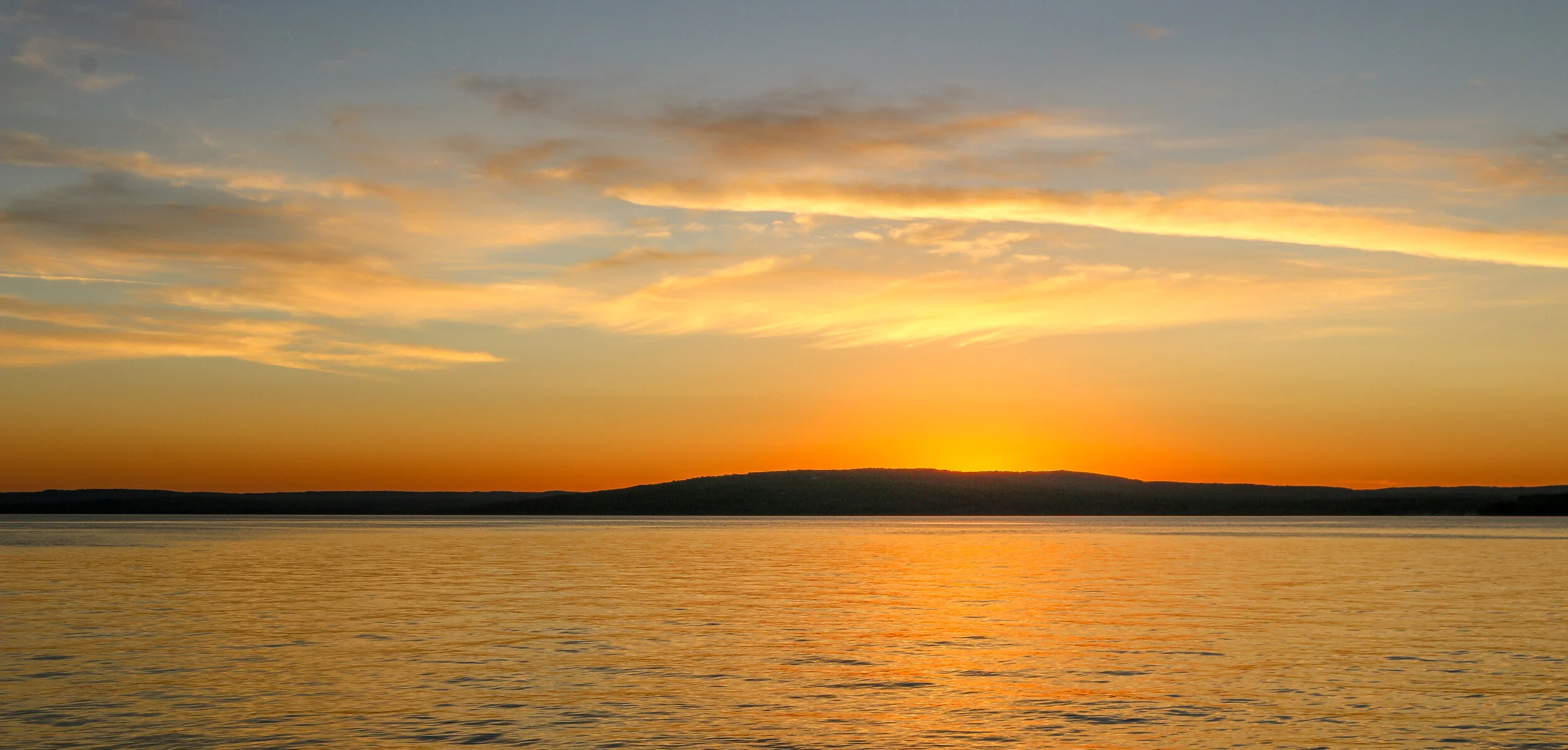
I had a great visit to Madeline Island. The ferry only took about 20 minutes to make the crossing and I brought my van with me and stayed at wonderful Big Bay State Park on the far side of the island. The ferry docks at La Pointe, the island’s only town which has several restaurants, bars and shops. It’s also where I found Tom’s Burned Down Cafe, one of the coolest bars I went to in the state. I enjoyed hiking in the state park and a long drive around the island on a very well maintained dirt road. I was sorry that the museum was closed when I was there, but I’m sure it had some interesting artifacts in it. Sunset over Lake Superior looking back at the mainland was magical. I hope you enjoy these photos from my time on beautiful Madeline Island.