Viewing entries in
Photography

This Week on the Road - April 21st-27th

Comment

This Week on the Road - April 21st-27th

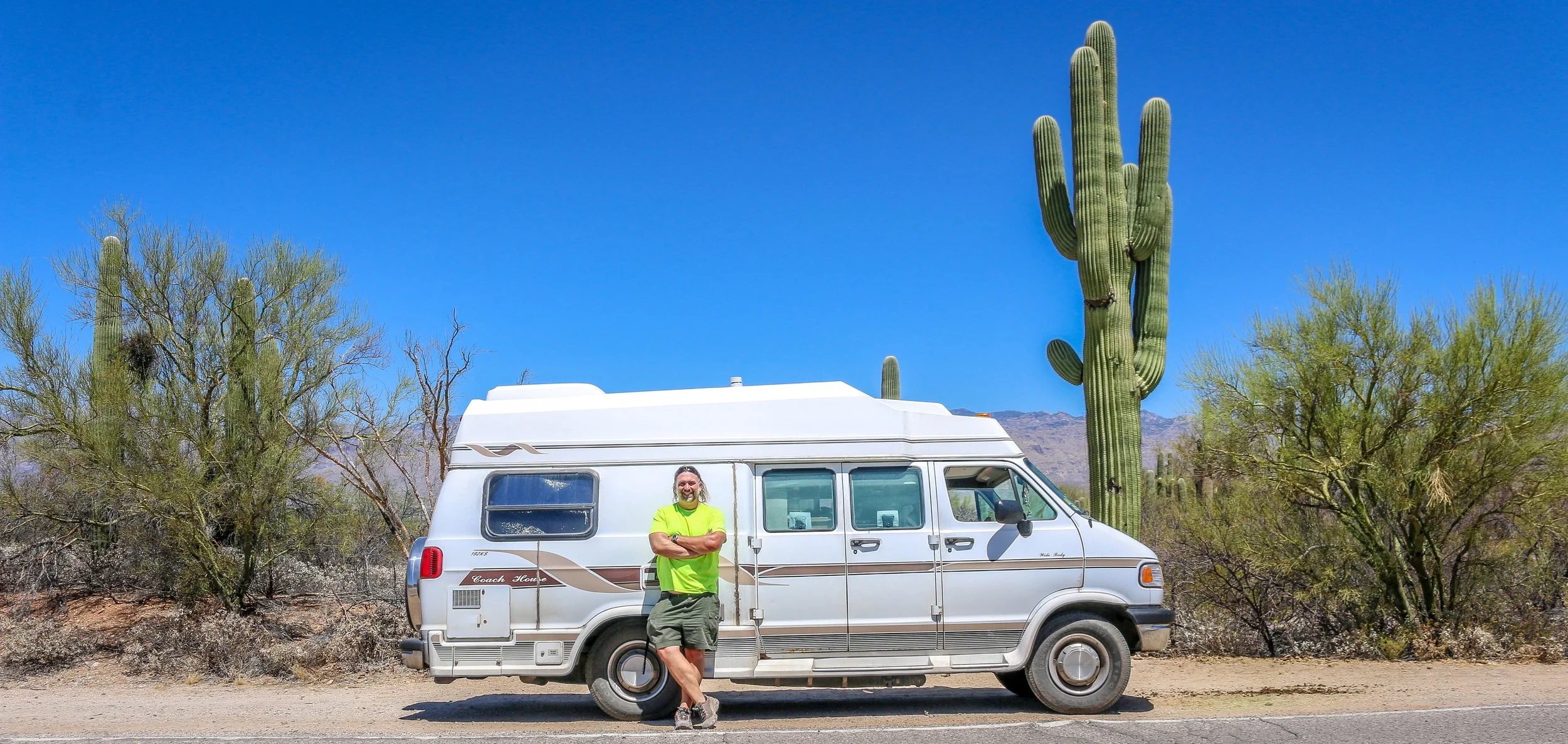
Hello Everyone! It is hot, hot, hot here in Southern Arizona – too hot in fact. Yesterday’s temperature hit 100° Fahrenheit in Phoenix and it has been above 90 for most of the week. It’s wonderfully pleasant in the mornings and the late evenings, but the days have just been too hot and my productivity, enjoyment and morale have all suffered as a result. I spent most of the last week in Tucson for various reasons, but don’t feel as though I accomplished much. I was thrilled to finally get out to Organ Pipe Cactus National Monument this week, but when I got there I ended up scouting out some shade to sit in until the sun started going down. I decided yesterday that I will throw in the towel and head north to higher elevations. I’m in my last couple of weeks of freedom before I head back to work for the summer and I want to enjoy them instead of suffering through them. I will stay in Arizona for now, but I will not get to see all of the places I wanted to at these low elevations. I’m sure this part of the country will be quite pleasant in December when I return. That all being said, I did have some nice experiences this week which I am happy to share with you all, but this will be a shorter newsletter than usual.

When I left off last week, I had only just arrived in Tucson and had been out exploring the wonders of Saguaro National Park. When I finished my hikes out there, I stopped off to get a wonderfully refreshing Eegee, an interesting brand of smoothie found only in Tucson. I also got my first of two “Sonoran Dogs” - bacon wrapped hot dogs with a southwestern array of toppings. The one I got on Wednesday was from El Guero Canelo and it was delicious, but I preferred the one I got at BK’s later in the week.

I spent much of Thursday in the library but headed out to the opening day of the Pima County Fair in the late afternoon. It was a cute midsized fair with plenty of rides and games and places to eat. I enjoyed the sea lion show and the pig races and, of course, taking photos of the wildly colorful carnival. The food was terribly overpriced even by fair standards in my opinion, so I settled for a funnel cake which was sadly quite small and not very fresh for my $11. It was definitely fun to be there, though, and I have really missed these types of events. I had a couple of beers and saw some live music, but called it a night pretty early.

On Friday I headed down into Old Town Tucson to see what it had to offer. I started my visit at the old Presidio, which is a re-creation of the fort that once stood high above the river to protect the area. I was thrilled to get a guided tour of the Presidio by Raul, a lifelong Tucson resident, now retired, who was both pleasant and knowledgeable. I found it fascinating that the man in charge of building many of the old Spanish forts, which stretched from the Gulf of Mexico to Tucson along New Spain’s northern frontier, was an Irishman named Hugo O’Connor who had fled religious persecution and joined his fellow Catholics in Spain. I also enjoyed reading about Jose de Urrea, one of Tucson’s most famous native sons. He joined the Spanish army in 1807, but later joined the Mexican call for independence. He went on to fight for Mexico against the Texans in their war for independence, and I first heard his name at Goliad in Texas, which I visited right before the pandemic sent me home. He later served as governor of the Mexican state of Sonora, but later returned to the military to fight against future U.S. president Zachary Taylor in the Mexican-American War. His was definitely an interesting story, one of many I found in the small but informative Presidio.

From there, I went just up the street to the old courthouse, a beautiful building which now houses the main visitor center for the city. Upstairs there is a small museum which looks at some of the crime and justice aspects of Tucson history. I was intrigued by the Arizona Supreme Court case of Ann Jordan and Henry Oyama which challenged the state’s interracial marriage policy. After so much time in the Deep South, it’s easy to forget that these laws were not simply Black and White. Oyama was an American-born World War II veteran with a master’s degree from the University of Arizona, but his Japanese ancestry prohibited him from marrying Ms. Jordan, who was White. The courthouse was also the site of the trial of Public Enemy Number One, John Dillinger, one of America’s most infamous bank robbers…

Comment

Snapshots: Rio Grande del Norte National Monument

Comment

Snapshots: Rio Grande del Norte National Monument

Rio Grande del Norte is one of our more recent National Monuments, having been designated as such in 2013. It protects the confluence of the Red River and the Rio Grande which are both designated Wild and Scenic Rivers. Both gorges are gorgeous and the point of land above the confluence, called simply El Punto, provides amazing views from high above the two rivers. I hiked the Little Arsenic Trail while I was there, which brought me down to the Rio Grande and led me straight to the confluence. It was one of the better hikes I did during my stay in New Mexico and was very rewarding around every turn. I spent the night at the campground on the canyon rim and enjoyed a beautiful sunset in the evening and a magical sunrise the following morning. In between, the stars were spectacular. I debated whether to drive out to this park as it was somewhat out of the way, but I’m sure glad I did as it is stunning from end to end. If you’re ever in the area, you should as well. I hope you enjoy these photos from beautiful Rio Grande del Norte National Monument.

Comment

Snapshots: Red River - New Mexico's Classic Ski Town

Comment

Snapshots: Red River - New Mexico's Classic Ski Town

Shhh. This is one of the towns nobody wants me to tell you about. Red River is a stunning little ski town along the Enchanted Circle in Northern New Mexico. It looks a lot like a Colorado ski town, but smaller, quainter, cheaper and with that special New Mexico sense of enchantment. I was there on a beautiful spring morning when the sun was shining but the air was cool and crisp. Despite plenty of snow on the mountain, it was sadly closed for the season.

Native Americans have hunted up and down the Red River for centuries, but the town’s beginnings were as a mining camp in the late 19th century when gold, silver and copper were being pulled from the hills. The town boomed to a population of around 3000 by the turn of the century, and as the mineral deposits started to dwindle, Red River gained a reputation as a cool weather getaway and a trout fishing paradise.

Red River today has a year-round population of just around 500, but it will multiply many times over on winter weekends when the town is buzzing with vacationers. No matter where you are staying in town, you could probably walk to the slopes with the lifts taking off from right in the center of town. In the warmer months, the area is full of trails and fishing is still a major draw and the the high elevation makes it cooler than towns to the south, east and west. I loved my short stay in Red River and it is one of the towns that I will definitely be returning to in the future. I hope you enjoy these photos from Red River, New Mexico’s classic ski town.

Comment

Snapshots: Nara Visa - A Modern Day Ghost Town

37 Comments

Snapshots: Nara Visa - A Modern Day Ghost Town

Nara Visa, New Mexico got its start as a rail town when the Chicago, Rock Island and Pacific Railroad was being built around the turn of the 20th century. It was originally called Narvaez after a local family who had farmed in the area for decades, but was eventually anglicized to some degree to Nara Visa. Within a decade, the town had grown to include 4 churches, 8 saloons, a couple of hotels and a whole array of small businesses. In 1921, with a growing population of 651, a fine school was built and the Works Progress Administration helped add a gymnasium a decade and a half later. The depression took its toll on the town though and lean years were ahead for Nara Visa. By 1968, there were only 7 students enrolled at the school when it closed its doors for the last time. Today less than a hundred people call the town home, and none of the businesses from this once thriving little community are open. It’s easy to pass through Nara Visa and not see it at all. I’m glad I got out and had a look. It makes me sad when towns die, but the reality is that everyone leaves at some point, one way or another. It looks like times were good there once, and maybe will be again at some point in the future. It sure made for some nice photos though. I hope you enjoy these photos from Nara Visa - a modern day ghost town in eastern New Mexico.

37 Comments

This Week on the Road - April 13th-20th

2 Comments

This Week on the Road - April 13th-20th

Hello Everyone! First and foremost I wanted to wish those of you who celebrate a belated Happy Passover and/or a belated Happy Easter. As those of you who have been following me for several years already know, I was brought up in the Eastern Orthodox tradition so we do not celebrate Easter before or during Passover. Our Easter will be this coming Sunday this year so it totally slipped my mind last week. I hope if you were celebrating that it was a wonderful day however you chose to spend it. This week has had considerably fewer headaches than last week which I’m very grateful for. I have traveled down the east coast and across Southeastern Arizona this week, visiting with and learning about the Apache, exploring Arizona’s copper mining past and present and checking out some beautiful National Park Sites along the way. Since I’ve come down about 5000’ in elevation from the high desert to the low desert, the temperature has risen considerably with daily highs reaching into the 90s. Thankfully it is a dry heat, which really does make a huge difference, and it cools off at night which is the most important thing. I am trying to avoid being outside and/or driving in the heat of the day at this point, but overall it hasn’t caused me any problems. I’ve certainly seen some fascinating places this week, so let’s get right to it.

When I left you last week, I was in the interestingly named town of Show Low which was a quaint and quiet vacation town which seemed nice enough but didn’t have much of interest to me. I spent Wednesday night just a little bit south of there in Pinetop and was up and off early the next day. I headed straight for the White Mountain Apache Reservation which is centered around the old Fort Apache. Fort Apache was built there at the confluence of the East and North Forks of the White River beginning in 1870. The fort was built in that location with the permission of the White Mountain Apache, and many members of that band served as scouts in the U.S. Army during the Apache War which was waged mostly with the Chiricahua Apache. I was fascinated to learn about this conflict between the different bands at the wonderful museum and cultural center located there at the old fort, and it seemed to me as though they were proud of the role their ancestors played in that campaign. The fort remained an active one until 1924 and after it closed the buildings were converted into the Theodore Roosevelt Indian Boarding School which educated both Navajo and Apache children. I’m not a huge fan of the Indian Boarding Schools, which sought to strip young Native Americans of their culture, but I do believe there were good intentions involved. The campus is still a school today, but run locally by the White Mountain Apache. I spent the morning at the museum which, while it discussed some of this history, was clearly designed to present the White Mountain Apache as a modern community proud of its heritage and working towards the future. I spent the afternoon touring the old fort and trying to soak it in. Everyone I met there was incredibly friendly and welcoming and I spent considerably longer there than I had planned. I did get out to visit the Kinishiba Ruins in the afternoon which is a small Ancestral Puebloan site just down the road. It is protected and managed jointly by the White Mountain Apache, the Hopi and the Zuni, all of whom claim ancestry at Kinishiba. From there I was off to the twin cities of Eager and Springerville for a quiet and an early night.

Friday morning I was up early and headed down the Coronado Trail Scenic Byway which at some point likely crosses the trail Coronado took in 1540 on what was the first European penetration into the region. What their exact route was is unknown as there were no maps of the region for them to follow, but there is evidence that they spent time in that general vicinity. The scenic byway was a beautiful, winding 120 mile route which took every bit of four hours to travel. There were some stunning viewpoints along the way as I descended out of the White Mountains and into the desert below. It was a great road to crank up some good tunes, roll my windows down and cruise. At the other end of it, I found myself in the heart of the Morenci Mine, the largest copper mine in North America. It’s not pretty by any measure, but it is massive and definitely something to see. The small town of Clifton, on the other end of the mine, was an interesting little place to visit. The main street through town was a dirt road and a narrow one at that. The buildings were definitely a century old and not necessarily in very good repair for what should be a prosperous mining town. Everything seemed coated in red dust. It was unlike anywhere I’ve seen in the US and reminded me of some of the small mining communities I visited in Western Australia. They did have a beautiful old train station though. From there I was off and running towards Safford, another 45 minutes or so down the road. When I got there I was excited to see a Jack in the Box, one of the only fast food restaurants that I actually like. I don’t eat fast food as a general rule, but I haven’t seen a Jack in the Box in years, so I treated myself. Then I headed out to a great little private hot springs park called the Essence of Tranquility. The owner was super friendly and I had a wonderful night there soaking in the tubs and kicking my feet up in the communal areas. While I stayed in my van, they do offer little casitas and dorm beds as well. It’s definitely a worthwhile little stop and it was a nice respite from the road for a night.

I had a quick soak in the morning as well and then set off to Fort Bowie National Historic Site high up on Apache Pass…

2 Comments

Snapshots: Tucumcari - Getting My Kicks on Route 66

Comment

Snapshots: Tucumcari - Getting My Kicks on Route 66

The area that is now Tucumcari was once home to dinosaurs who walked the shores of an inland sea. When the water receded, the sediment formed into sandstone and one of the formations it left is now called Tucumcari Mountain (although it’s really more of a mesa). Prehistoric people tracked mammoths and mastodons in the area and later developed farming techniques and built villages. In the 18th century, the Apache and Comanche moved through the area, hunting bison and pronghorn. The name, Tucumcari, comes from an Apache word “tukanukaru,” meaning “to lie in wait for something to approach”. In the early 20th century, the Chicago, Rock Island and Union Pacific Railroad was making its way across the country and a tent city sprung up called Ragtown and, later, Six Shooter Siding. As the camp grew into a town, they changed the name to Tucumcari and it stuck. Route 66 came through in 1926 and the town became an overnight stop for people headed west. Signs for miles declared “Tucumcari Tonight” and people pushed through for the promise of a hot meal and a comfortable bed. Tucumcari today still capitalizes on nostalgia for the “Mother Road”, but also has a wonderful museum downtown which has a place for everything and everything has been lovingly put into place. I had a great stop in Tucumcari and definitely got my kicks on Route 66. I hope you enjoy these photos from beautiful Tucumcari, New Mexico.

Comment

Snapshots: Clovis - New Mexico's Rock and Roll Capital

Comment

Snapshots: Clovis - New Mexico's Rock and Roll Capital

People have been in the Clovis area for at least 10,000 years as is evidenced by the “Clovis-man” finds at the nearby Blackwater Draw archaeological site. The town itself came much later, in 1906 in fact, when the Atchison Topeka and Santa Fe Railroad was making its way across the country. It’s the first town of any size you’ll find coming from Texas and the town has some Texas tendencies to be sure. It’s grown to a population of nearly 40,000 people and is the county seat of Curry County. For all it has to offer, it was a man named Norman Petty that brought me to Clovis. Petty started playing piano at an early age and in his mid-twenties had a hit record with his wife, Vi, and guitarist Jack Vaughn when they recorded the great DC born Duke Ellington’s Mood Indigo. The record’s success gave Norman enough money to open his own recording studio and in 1954 the Norman Petty Recording Studio was born. Petty recorded local artists and plenty from nearby Texas as well. In 1957, he produced a hit called Party Doll for Happy, Texas’ Buddy Knox. It was another Buddy though, Buddy Holly, who would really put Petty and Clovis on the music map. Norman would go on to produce records for Roy Orbison, Bobby Vee, The Fireballs and many others and their distinct style would be remembered as the Clovis Sound. I had a great time in Clovis and found a lot to like about it from its art deco buildings to its wonderful Vi and Norman Petty Museum. The downtown wind art was both beautiful and appropriate. Sadly it was cloudy for much of my visit, but it did manage to clear up right before I left so I did grab a few photos under sunny skies. Who knew New Mexico played such an important role in music history. If you’re ever in the area, stop in and check it out. I hope you enjoy these photos from musical Clovis, New Mexico.

Comment

In Focus: Fort Union National Monument

Comment

In Focus: Fort Union National Monument

After the Treaty of Guadalupe Hidalgo ended the Mexican-American War in 1848, New Mexico officially became a part of the United States. Americans started moving west to try and stake a claim in this new territory, but were often met with hostility by Indians trying to protect what they believed belonged to them. In response, the U.S. government built Fort Union at the main junction on the Santa Fe Trail. The original fort was good enough for that purpose, but a second, stronger, fort was built during the Civil War and a third fort soon replaced the second. The fort served two main purposes which were independent of each another - one being a military post and the other, a quartermaster depot. The depot was the supply hub for the government in the southwest and received hundreds of wagonloads of supplies daily to support 46 regional posts. There was also an arsenal on the base which could have also been seen as a separate entity as it had its own commander and staff. In addition, the base hospital provided the best medical care for hundreds of miles around. Fort Union served as the jumping-off point for Union forces on their way to fight at Glorieta Pass, the last Civil War battle fought in New Mexico. After the Civil War, African-American soldiers with the 57th U.S. Colored Infantry arrived at Fort Union and later the 9th U.S. Cavalry, remembered today as the Buffalo Soldiers, would join them. When trains started rumbling across the country at the end of the 19th century, Fort Union became obsolete and was decommissioned in 1891. The last soldiers left on May 15th of that year. In 1954, it became Fort Union National Monument and its history is now interpreted by the National Park Service.

Most of the fort was built of adobe which, without regular maintenance, will melt back into the desert. Some exceptions were the stone jail and the brick chimneys which provide a glimpse into what Fort Union once was. This park site doesn’t get many visitors, but it’s a fascinating place to learn about the Santa Fe Trail and early American history in the New Mexico Territory. I hope you enjoy these photos from fascinating Fort Union National Monument.

Comment

In Focus: Pecos National Historical Park

Comment

In Focus: Pecos National Historical Park

Construction of the pueblo at Pecos was begun sometime in the 12th century. Over the next few hundred years it would grow to become one of the largest pueblos in the area, supporting a community of perhaps 3,000 people. Sitting in what is now eastern New Mexico, this agricultural community was also a trade center between the mountains to the west and the plains to the east. Francisco Vázquez de Coronado visited Pecos on his 1540 conquest, as did Don Juan de Oñate 60 years later when he ordered construction of a mission church to help convert the Puebloans to Catholicism. That church was destroyed during the Pueblo Revolt of 1680 and a smaller church would be built in its place when the Spanish returned to the area twelve years later. The spread of European diseases would bring the ultimate demise of Pecos and in the 1830s the last of its old residents made their way to Jemez Pueblo where their culture and tradition is still remembered in the oral history. Emigrants on the nearby Santa Fe Trail no doubt used Pecos as a campground and marveled at the old pueblo. General Kearny and his troops camped at Pecos as well on their westward journey to claim New Mexico for the United States. During the Civil War, the Confederate army was making their way through New Mexico on a quest for Colorado and California gold. Their troops turned back to Texas after being defeated at the Battle of Glorieta Pass which is right up the trail from Pecos. Tex Austin purchased the land in 1925 and turned it into the Forked Lightning Ranch which was purchased in 1941 by Buddy Fogelson. The Fogelsons were instrumental in creating Pecos National Monument in 1965, and after their deaths the park’s boundaries were expanded to include the ranch and the designation changed to Pecos National Historical Park.

Today the park does an incredible job of interpreting all of this fascinating history in its wonderful museum. The 1.5 mile trail takes you through the remains of the pueblo and into the ruins of the old mission church. Two kivas have been reconstructed to provide some insight into Puebloan culture and religion as well. It’s a beautiful place to visit and just a short drive from nearby Santa Fe. I hope you enjoy these few photos from fascinating Pecos national Historical Park.

Comment

This Week on the Road - March 30th - April 6th

Comment

This Week on the Road - March 30th - April 6th

Hello Everyone! It’s been another amazing week out here in New Mexico and I can’t wait to tell you about it, but I’m going to start out this week with my most exciting news. As most of you know, I will be going back to my regular gig as an overland tour guide this summer. I’ll be working for a company called Incredible Adventures which is currently being run by my last two managers from my old company. I got a call from one of them yesterday with some thoughts on my start-up tour and I will be heading to Hawaii next month. Of all the places I thought I might go this summer, Hawaii was not on my list and I am so excited for this opportunity. It will be in the midst of my time in Arizona, but I will fly out and then back and be able to finish up my time there before heading on to San Francisco to begin my season in earnest. I am definitely looking forward to walking barefoot on a white sand beach and swimming in beautiful turquoise water. So with mai tais and sea turtles dancing in my head, let me tell you about my exciting week here in New Mexico.

When I left you last week, I was planning on heading to a place called Meow Wolf the following morning. Meow Wolf was an incredible experience which is really hard to explain. It’s essentially a big funhouse, full of fascinating and beautiful art installations. You enter it through the front door of a Victorian house and then you choose your own adventure from there. You can go through the fireplace into an ice cave with a mammoth skeleton which you can play like a xylophone. You can go through the refrigerator which takes you to a strange vacationland. You can go through the bookcase and come out in a circus-like room. You end up in treehouses and lighthouses and flying buses. It really is quite a place to experience and I was there for probably three hours and continued finding new rooms and passages right up until the end, and I’m sure I missed some along the way. It was weird and wonderful and I would definitely recommend it if you are ever in Santa Fe (or Denver or Las Vegas).

My Thursday afternoon was definitely one of ups and downs. I got a call from my dad telling me he had fallen and broken his ankle. He’ll be okay and is in a recovery facility, but I worry about some of these places and what floats around in them with Covid only being one such worry. On the flip-side, I got a nice email telling me one of my photos has been accepted to be published in a book of hiking trails from National Geographic called 100 Trails, 5000 Ideas. As a photographer, National Geographic is obviously one of the biggest names in the industry and while it will be a small photo in a big book, I’m still very happy to be included. In the afternoon I headed over to visit the Montezuma Masonic Lodge, where the gentleman I met in Taos told me I could find Kit Carson’s rifle. I met several of the Masons who were a part of the Lodge when I walked in, and they were incredibly warm and welcoming. The Secretary, Don, told me the whole story of the rifle and how Kit himself had instructed that it be hand delivered to the Lodge upon his death. It was, and they’ve been caring for it ever since. I had to put on a pair of gloves to hold it, but it was amazing to have this piece of history in my hands. I’m very grateful to the gentlemen of the Montezuma Lodge for their hospitality and all of the fascinating stories they shared with me while I was there. I decided to celebrate the day with a few beers at La Fonda, a wonderful must-see hotel right off the central Plaza in downtown Santa Fe. Mark has been bartending at La Fonda for years and it’s always a pleasure to stop in and say hello and have a drink in historic surroundings. From there, I said goodbye to Santa Fe and headed up the highway to the Buffalo Thunder casino for the night.

I started my day on Friday at Bandelier National Monument, not far up the road. Due to its proximity to Santa Fe it’s a busy park and it was fairly crowded when I was there, but there were some great old ruins to poke around at the base of some beautiful cliffs. When I had had my fill of the ruins, I had some lunch and then set off up the other side of the canyon on the Frijoles Rim Trail. It was a wonderful and beautiful trail and, in contrast to the valley, I didn’t see a single person along the whole hike. The trail took me up to the top of the canyon and along its rim for a mile or so and there were wonderful views down the canyon and off to the mountains in the distance. When I made it back to my van, we were off and running to Los Alamos to have a short look around Manhattan Project National Historical Park before it closed. I had been to another section of this park several years ago in Oak Ridge, Tennessee where they had enriched the uranium which was then transported to Los Alamos and built into the atomic bombs. They tested their first bomb at the Trinity Site down near what is now White Sands National Park…

Comment

Snapshots: Las Vegas - New Mexico's Historical Gem

4 Comments

Snapshots: Las Vegas - New Mexico's Historical Gem

“The Original Las Vegas” was founded along the Galinas River in 1835 in the midst of Mexican rule in the area and quickly grew as a popular stop on the Santa Fe Trail. It was on the Plaza in Las Vegas where Stephen Watts Kearny claimed New Mexico for the United States during the Mexican-American War in 1846. In 1879, the Atchison, Topeka and Santa Fe Railroad came to Las Vegas and the town quickly grew into one of the largest in the region. The New Mexico Normal School (now Highlands University) was established in 1893 and Fred Harvey built the Castañeda Hotel in 1898 as part of his hospitality empire in the southwest. Las Vegas hosted Teddy Roosevelt’s Rough Riders’ first reunion in 1899, a tradition that continued for many years. In more recent years, Las Vegas has been the filming location for many movies including No Country For Old Men, Wyatt Earp (with Kevin Costner), and perhaps most notably for me, Red Dawn where it served as the fictional town of Calamut (the massive “Calamut Says Howdy” mural is still a prominent feature downtown). I found Las Vegas to be a quiet, charming University town with some spectacular architecture, fascinating history and friendly people. It may be the “other Las Vegas”, but it’s a town not to be missed on your travels in New Mexico. I hope you enjoy these photos from wonderful Las Vegas, New Mexico.

4 Comments

This Week on the Road - March 23rd-30th

Comment

This Week on the Road - March 23rd-30th

Hello Everyone! It’s been a wildlife viewing week out here on the roads of Northern New Mexico. I’ve seen eagles and hawks in the air, deer, bighorn sheep and pronghorns in the fields and lots of prairie dogs running around searching for their underground tunnels. I like seeing wildlife. These animals make me smile. I’ve actually done a lot of smiling this week as I’ve found myself in wild places surrounded by beautiful landscapes and breathtaking sunrises and sunsets. I’ve managed to keep most of the demons in my head at bay this week and have felt pretty good all around. The weather has generally been great this week as well which hasn’t hurt. Warm, sunny days and cool, pleasant nights work really well for me. I do find that I need to change from shorts to long pants very soon after the sun goes down – it doesn’t take long to cool down in this dry air. It’s hard to believe I’ve been in New Mexico for over a month at this point, but I’m starting to make plans for the final stretch of my time here and then I’m off to Arizona for the rest of my winter/spring. My month in New Mexico has been special and memorable and I definitely understand why they call it The Land of Enchantment.

When I left you last week, I was in tiny Clayton, New Mexico in the far northeast of the state. I did head out to Clayton Lake State Park that evening which has a fascinating “pad” of over 200 dinosaur footprints from when the area was the muddy shoreline of a vast inland sea. Some of the footprints were very pronounced in the evening light and while it was very windy out there it was still really cool to see. I decided to spend the night at one of the campgrounds by the lake and ended up having the whole place to myself which was really nice. It was windy and cold, but I stayed out to watch the sunset and then popped out periodically to check out the stars which were really bright and mesmerizing.

Thursday morning I stuck around my campsite for a bit, enjoying my coffee and the warm sun on my face by the lake. I’ve been rereading the book Blood and Thunder by Hampton Sides which essentially tells the history of early American New Mexico. It’s an excellent book, and I’m enjoying it even more now that I’ve been to a lot of the places he writes about. A pair of bald eagles were cruising around the lake while I read which was awesome. Eventually I pulled up stakes and headed back into town to take a few more photos and then got on the road west to Capulin Volcano National Monument. I had noticed on my way out to Clayton Lake the evening before that the landscape was much more volcanic in that part of the state and it became even more pronounced as I went west. I drove past Sierra Grande, which is an incredible example of a shield volcano and then headed towards Capulin which is one of the country’s best specimens of a cinder cone volcano. This volatile and quick-forming volcano (which looks like what you imagine in your head when you think of a volcano) formed sometime around 60,000 years ago. The fertile soil it produced made for some fine grazing land so ranchers have used the land around the volcano for centuries and its distinct and easily recognizable shape made it a landmark on the Santa Fe Trail. Today, you can drive right to the top which is pretty cool but probably not for the faint of heart as there is a pretty severe drop-off and not many guardrails on the road. Once you get up there, though, you are rewarded with remarkable views in all directions and you can hike around the rim and down into the crater. You can look east at the seemingly endless plains stretching to the horizon and west to where they run into the Rocky Mountains. When I left the park, I headed north to Folsom and planned on taking the road over Johnson Mesa to Raton so I could drive past the Folsom Man Site, an archaeological area similar to the Clovis Man Site I talked about last week when I visited the Blackwater Draw museum. Somehow I took a wrong turn and ended up going a half hour down the wrong road but it was a beautiful road and a nice detour. When I finally figured out I had gone astray, I returned to Folsom and found the road I wanted to take. It was poorly marked and when I made the turn, I found it was also closed. Two hours later, I was back at Capulin but thankfully it was only a short drive from there to Raton. Raton is a cute little town on the railroad line with an old theatre and an older train station. I did wander around town a little bit but I was pretty tired and didn’t find out much about it. I stopped in for a great craft beer and one of the best burritos I’ve ever had at the Cellar Brewery (which is actually on the first floor, but they brew the beer in the basement) and then called it a night.

On Friday morning I headed just down the road to the town of Cimarron. Their sign reads “Where the Plains Meet the Mountains” and you can look west from town and see the Rockies emerging from the flat plains. Cimarron is also home to the Philmont Scout Ranch, a massive wilderness area donated by oilman Waite Phillips to the Boy Scouts in 1938. Way back in 1992, I came to Philmont on my very first trip to New Mexico and my first trip anywhere west of the Mississippi. My Boy Scout troop spent 10 days backpacking through the Sangre de Cristo Mountains and covered about a hundred miles on foot if my memory serves. It was an amazing experience for a city kid like me and a formative one…

Comment