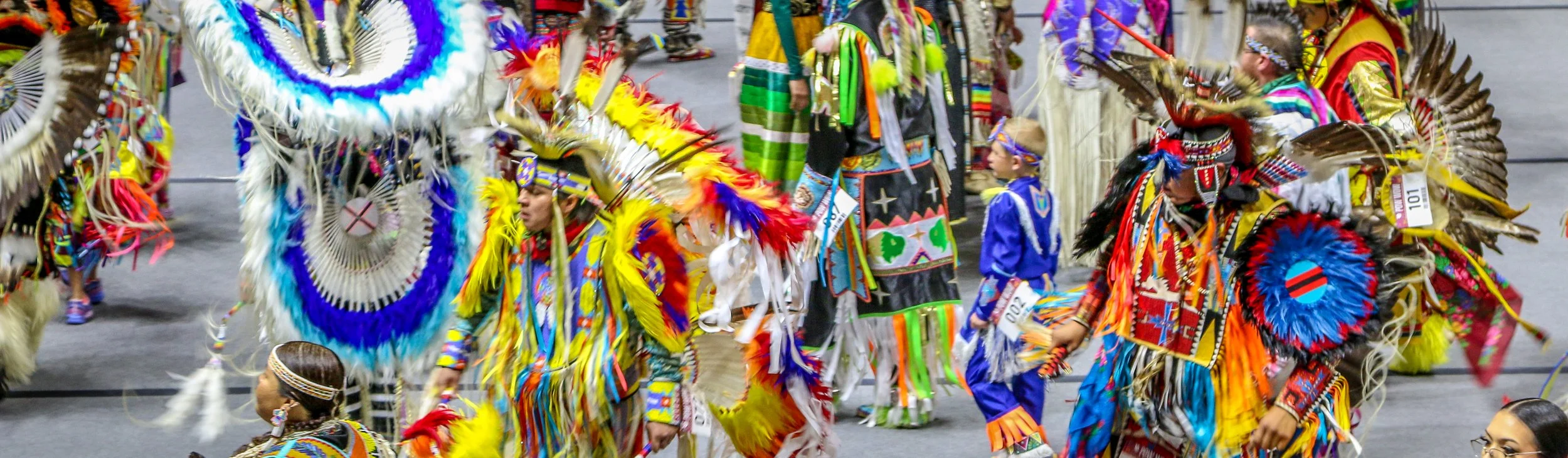
It was truly a privilege to once again be able to attend a Native American powwow. Powwows are gatherings of American Indians to celebrate their shared culture with an emphasis on music, drumming and dance. Threading Our Legacies Powwow was held at the basketball arena on the University of Utah campus in Salt Lake City. The Ute, Shoshone and Navajo tribes seemed to be the most well-represented tribes there, but it also seemed as though people had come from far and wide to participate. During the Grand Entrance which begins the powwow, hundreds of dancers followed the eagle staff and flags onto the floor and there were at least 5 drum groups to provide the rhythm of the day. Powwows are incredibly colorful events with participants wearing beautiful regalia which takes many hours to create. These photos are just a small sampling of the people who participated in the day but I hope they will give you some idea of how beautiful it was and how awesome it was to be there.
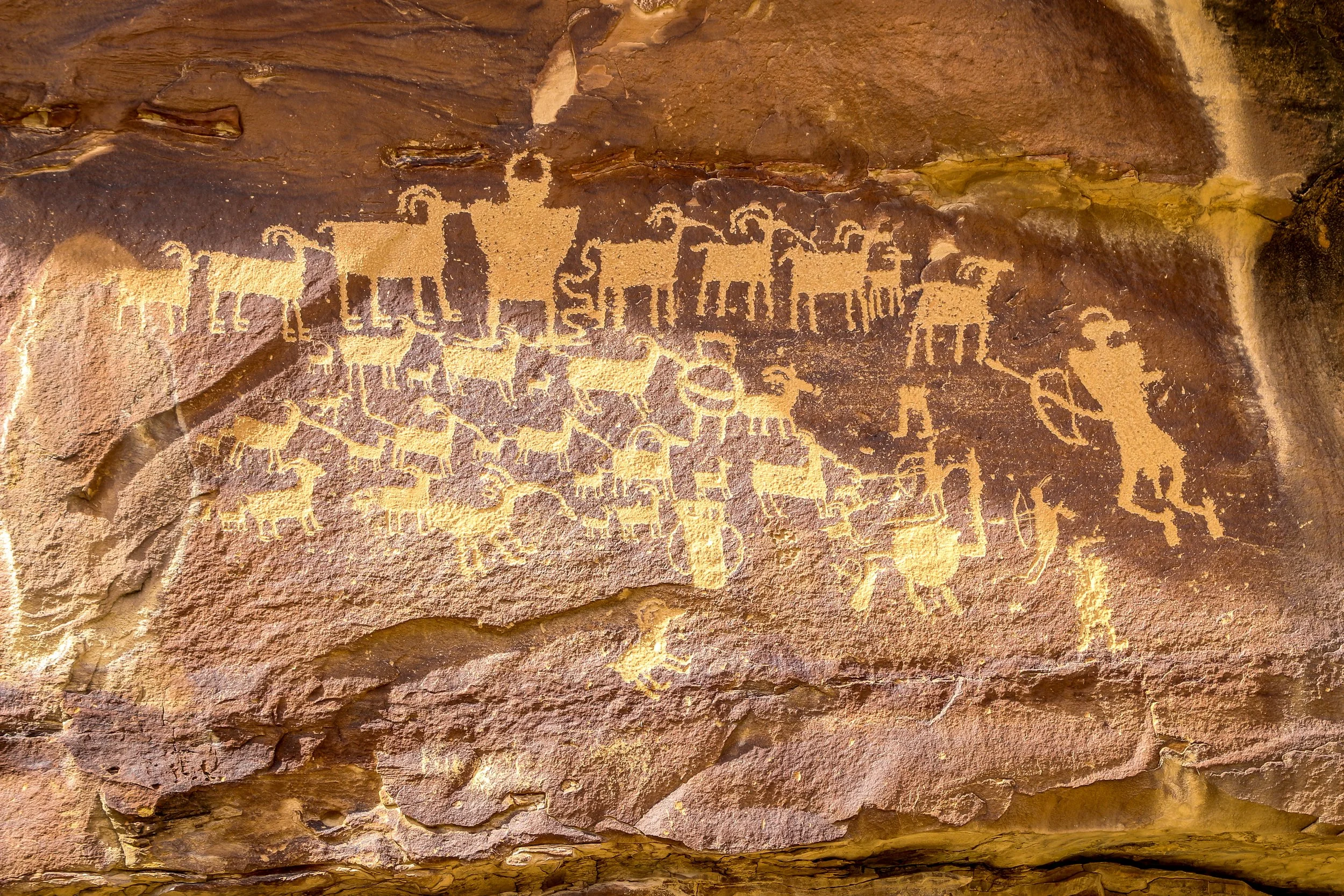
Nine Mile Canyon as often been called “The World’s Longest Art Gallery”. Despite its name, the canyon stretched 46 miles through east central Utah and has as many as 10,000 petroglyphs along its course. This route has been traveled for thousands of years, undoubtedly beginning as a wildlife trail which followed the easiest path through the mountains. It was used by a people we refer to as the Fremont People for many hundreds of years and they are responsible for most of the petroglyphs chipped into the canyon walls. Later, Ute Indians made their way through the canyon and made their own carvings, including those of horses and bison. Fur trappers and settlers followed the old Indian trails. The Nine Mile Canyon Road was originally built by the Black Buffalo Soldiers of the Ninth Cavalry to connect old Fort Duchesne to the railroad at Price. Once the road was complete, stagecoaches started using the canyon to deliver mail and freight and settlements began to spring up. Later, mining and natural gas extraction began in Nine Mile Canyon and continues today. Nobody knows how 46 mile long Nine Mile Canyon was named. Many people believe that explorer John Wesley Powell named it because the name first appears in his journals, but Powell was pretty good at naming things so I’m not buying that explanation. Also, I love a good mystery and don’t mind when one goes unsolved.
I started my drive from Wellington, just south of Price. The road is paved all the way to the Great Hunt Panel (and beyond if you continue up the side canyon), but has a stretch of decently maintained gravel road if you want to continue through to Myton (which I did). I loved seeing so many wonderful petroglyphs in such a small area and I know I only scratched the surface (pun intended) of what was out there. My favorite is the first one pictured below: Coyote Placing the Stars. I also loved the Owl Panel and the Juggling Man and of course the Great Hunt which is one of Utah’s most famous panels. There were a lot of old homesteads along the way and even an old townsite once called Harper but abandoned over a hundred years ago. There are some beautiful new homes out there as well and aside from the mining trucks rumbling past I imagine it’s pretty quiet out there most of the time. I really enjoyed my day out in Nine Mile Canyon and I hope you enjoy these photos I took along the way.
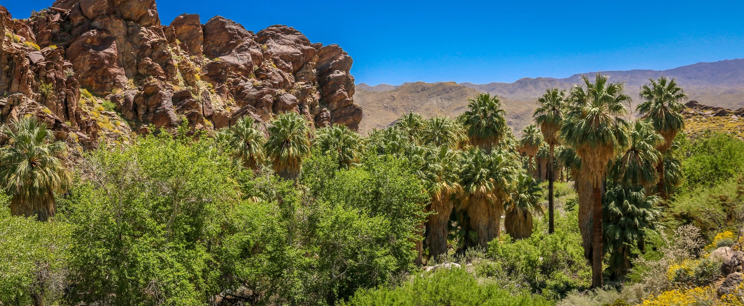
The natural oases of the Indian Canyons near Palm Springs have been home to the the Agua Caliente Band of Cahuilla Indians for a very long time. They had abundant water and were able to plant and harvest melons, corn, beans and squash. Today they welcome visitors to their homeland to hike, relax, and enjoy the natural beauty of the world’s largest California Fan Palm oasis. I was lucky to be there in the middle of a particularly wet spring and the wildflowers were absolutely stunning. Palm Springs didn’t do much for me, but I’m definitely glad I got to visit the magnificent Indian Canyons just outside of town. I hope you enjoy these photos of the super bloom in this wonderful desert oasis.
Father Eusebio Francisco Kino established the Mission San Cayetano de Tumacácori on the east side of the Santa Cruz River in January of 1691, making this the oldest mission site in what is now Arizona. The name “Tumacácori” is an English bastardization of a Spanish interpretation of an O’odham (Pima) word, the meaning of which has been lost. It is how the native people referred to this region. After years of violence at the hands of the Spanish, the O’odham people rose up in the Pima Revolt of 1751. Laying blame on the abuse of the Jesuits missionaries, they were pardoned by the colonial governor and the Jesuits would be expelled from the colonies beginning in 1757. The mission was moved across the river and renamed Mission San José de Tumacácori and the first actual church was built on this new site.
Franciscans would try and pick up where the Jesuits left off and in 1800 they began work on an ambitious new church, trying to match the majesty of Mission San Xavier del Bac to the north (a photo of which appears at the very bottom of this post). The church was never fully completed as the missions were closed when the Mexicans won their independence in 1821. Today, the mission is a part of Tumacácori National Historical Park and a visit is a must when you’re in the area. You can learn more about the O’odham people, the Spanish missionaries and colonial life in the missions and it’s a very cool place for a wander.
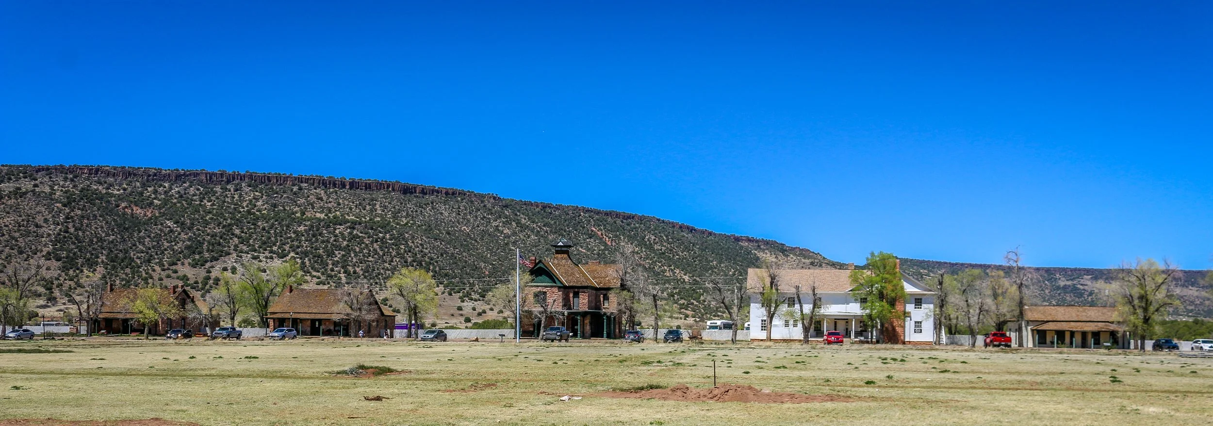
Fort Apache was constructed between 1874 and 1932 and served as an important military outpost during the Apache Wars. It rests in the midst of the beautiful White Mountains of Eastern Arizona. and is well situated at the convergence of the North and East Forks of the White River. The area is the ancestral home of the Cibicue and White Mountain Apache tribes who welcomed the United States Army to build the fort there, as they had a common enemy in the Chiricahua Apache. The White Mountain Apache are very proud of their service as scouts in the U.S. Army, and the role they played in the defeat of the Chiricahua and the capture of the great Chiricahuan leader, Geronimo. I learned a lot about the Apache Scouts and their campaigns at the wonderful "Nohwike' Bagowa" (House of Our Footprints), more commonly referred to as the Apache Cultural Center & Museum. which should be everyone’s first stop on any visit to Fort Apache.
After visiting the museum, I set off to explore the rest of the fort on a self guided walking tour which took in all of the wonderful historic buildings which remain on the post. After Geronimo’s capture in 1886, the fort remained an active military post for many years, finally closing in 1924 (although several Apache scouts remained in the army until 1947). After the army pulled out, the Theodore Roosevelt Indian Boarding School was established and the land was transferred to the Bureau of Indian Affairs as part of the White Mountain Apache Reservation. The school is still there and functioning today. I had a great visit with the kind and welcoming people of the White Mountain Apache band and really enjoyed my visit to this fascinating historic fort. I hope you enjoy these photos from Fort Apache.
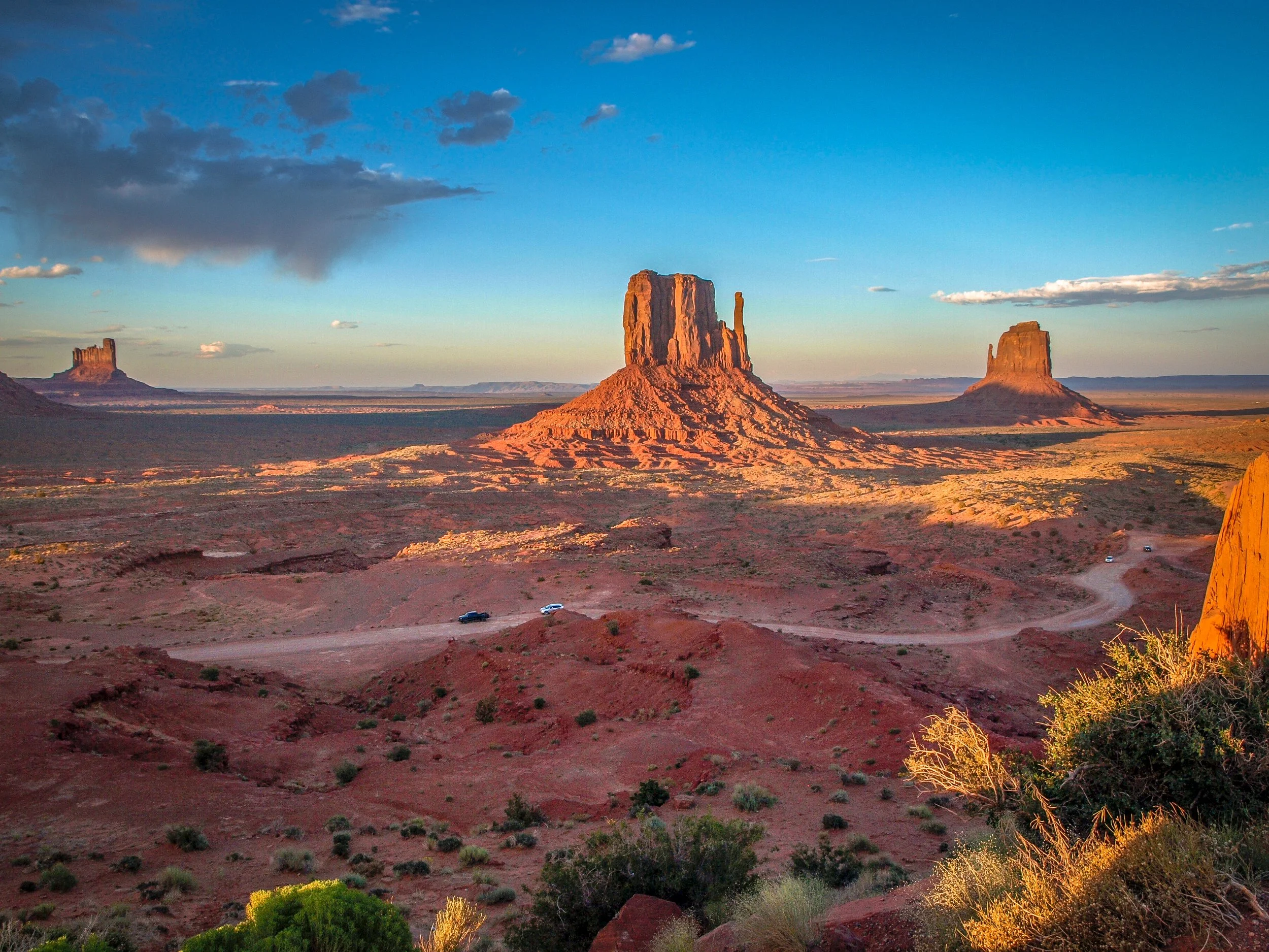
I’ve spent many months of my life on the Navajo Reservation, more than I’ve spent with any other Native American group. I’ve always found the Navajo People (or the Diné as they refer to themselves) to be warm and welcoming with a wonderful sense of humor. I’ve had the incredible opportunity to lead tours throughout the Navajo lands and to explore on my own as well. Some of these photos are from my recent travels on the Rez and some are old favorites. I hope they show the diversity of the landscape and the splendor of my time in Navajo Country.
Construction of the pueblo at Pecos was begun sometime in the 12th century. Over the next few hundred years it would grow to become one of the largest pueblos in the area, supporting a community of perhaps 3,000 people. Sitting in what is now eastern New Mexico, this agricultural community was also a trade center between the mountains to the west and the plains to the east. Francisco Vázquez de Coronado visited Pecos on his 1540 conquest, as did Don Juan de Oñate 60 years later when he ordered construction of a mission church to help convert the Puebloans to Catholicism. That church was destroyed during the Pueblo Revolt of 1680 and a smaller church would be built in its place when the Spanish returned to the area twelve years later. The spread of European diseases would bring the ultimate demise of Pecos and in the 1830s the last of its old residents made their way to Jemez Pueblo where their culture and tradition is still remembered in the oral history. Emigrants on the nearby Santa Fe Trail no doubt used Pecos as a campground and marveled at the old pueblo. General Kearny and his troops camped at Pecos as well on their westward journey to claim New Mexico for the United States. During the Civil War, the Confederate army was making their way through New Mexico on a quest for Colorado and California gold. Their troops turned back to Texas after being defeated at the Battle of Glorieta Pass which is right up the trail from Pecos. Tex Austin purchased the land in 1925 and turned it into the Forked Lightning Ranch which was purchased in 1941 by Buddy Fogelson. The Fogelsons were instrumental in creating Pecos National Monument in 1965, and after their deaths the park’s boundaries were expanded to include the ranch and the designation changed to Pecos National Historical Park.
Today the park does an incredible job of interpreting all of this fascinating history in its wonderful museum. The 1.5 mile trail takes you through the remains of the pueblo and into the ruins of the old mission church. Two kivas have been reconstructed to provide some insight into Puebloan culture and religion as well. It’s a beautiful place to visit and just a short drive from nearby Santa Fe. I hope you enjoy these few photos from fascinating Pecos national Historical Park.
Native Americans have been passing through the area we now call the Salinas Valley for thousands of years. As agricultural techniques developed, hunter-gatherer societies began to settle down, plant crops and build permanent communities. The communities which grew in the Salinas Valley combined the traditions of the people we call Mogollon with those of the Ancestral Puebloans. They traded with other Puebloan groups to the west and with the Plains Indians to their east.
When the Spanish arrived in 1540, Coronado was searching for the 7 Lost Cities of Gold. He never found gold, but found abundant salt deposits in these mountains which is where they get their name (“salinas” means “salt” in Spanish). While the treasure seekers were met with disappointment, the Franciscan priests who accompanied them found whole towns of souls they believed needed saving. They took up residence in these remote pueblos and oversaw the construction of massive churches. They brought with them items which changed these societies for the better like wheat, fruit, cattle, goats and sheep. They also brought disease and demands for the Native people to give up their rituals and traditions. Some of these pueblos contain kivas, the underground centers of Pueblo communities and religion which point to some level of compromise, since later missions had kivas filled in and destroyed. Spanish priests and governors were often in disagreement over how to treat the Puebloan people, and cultural conflicts would often erupt…
The homes we now refer to as the Gila Cliff Dwellings were built beginning around 1276. The rivers in the area provided a constant source of water, a necessity in the desert and probably the reason the people who built these dwellings chose this location. While they were contemporaries of the people we now call the Ancestral Puebloans, differences in their construction styles, pottery and art have caused archaeologists to give them a different name and we refer to them as the Mogollon. The time that the Mogollon spent in these dwellings, approximately 25 years, coincides with prolonged drought in the area which caused many groups to move in search of water. It seems that the Mogollon moved into these alcoves near the beginning of the drought, and left as it was ending. When looking at history, it’s easy to think of 25 years as the blink of an eye, but it’s a whole generation of children growing to adulthood and having their own babies and adults moving into the roles of elders as elders pass on. There was love and loss and laughter as this group passed the time farming, hunting, building, creating and growing.
The Mogollon seem to have moved on around 1300 as the drought was coming to its end and these isolated dwellings likely remained empty for quite some time. The Chiricahua Apache migrated to the region in the 1500s and the great leader Geronimo was born near the headwaters of the Gila River around 1820. Spanish settlers came to the area in 1598, but there is no evidence they penetrated the wilderness anywhere near to the dwellings. Prospector H.B. Ailman documented the cliff dwellings in 1878 and by the time archaeologist Adolph Bandelier arrived in 1884, looters had ransacked the alcoves and made off with whatever artifacts were to be found. Homesteaders, miners, prospectors and ranchers arrived over the next few decades and President Theodore Roosevelt protected the area as Gila Cliff Dwellings National Monument in 1907. Not too long after he did, Aldo Leopold came to the region as a forester and lobbied the Forest Service to establish the GIla Wilderness, the first designated wilderness area in the country and an inspiration for the 1964 Wilderness Act.
Today, the Gila Wilderness is a quiet and magical place. It’s a two hour drive from Silver City, the nearest town of any real size, to the Cliff Dwellings. The road that brings you in is the aptly named Trail of the Mountain Spirits National Scenic Byway and it is a truly beautiful drive. During my visit, I toured the cliff dwellings, scouted out some beautiful pictographs, hiked the fabulous Little Bear Creek Canyon trail to the Middle Fork of the Gila River and soaked in wonderful hot springs. I loved my time in the Gila Wilderness and hope you enjoy these photos from my visit.
The Three Rivers Petroglyph site offers an amazing look into the ancient rock carvings of the Jornada Mogollon people. These rock carvings, created between 900 and 1400 AD, are scattered across a boulder field in the Chihuahuan Desert between the San Andres and Sacramento Mountains. There are over 20,000 recorded petroglyphs in this area, making it one of the most prolific petroglyph sites in the country. While nobody knows the exact meaning of these chiseled carvings, some of the more recognizable animals and birds offer a glimpse into what these ancient people found important. Located 17 miles north of Tularosa and 28 miles south of Carrizozo, this site, managed by the Bureau of Land Management, makes an excellent detour. There is a $5 admission fee to the site, but it is federal land so all National Park passes are also accepted. You could make the one mile out-and-back hike in under an hour, but the longer you stay, the more you will see. I hope you enjoy these photos of a tiny fraction of the carvings at the Three Rivers Petroglyph Site.