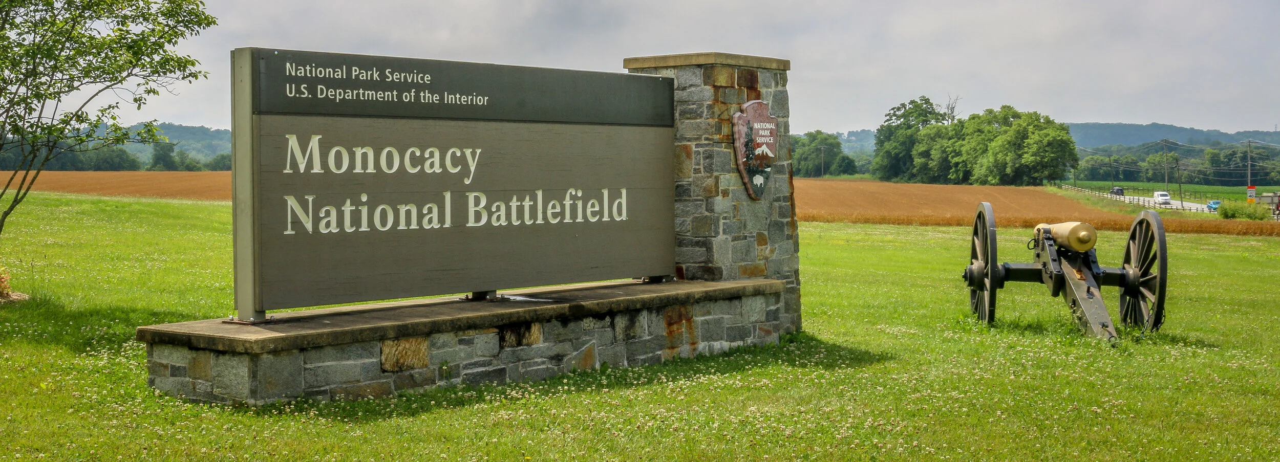
The photos below come from a recent visit to Monocacy National Battlefield Park just south of Frederick Maryland - site of the “Battle that Saved Washington”. Civil War Chronicles will trace the major battles of the Eastern Theater of the war through photos and brief histories.
The Battle of Monocacy is a bit of an outlier in that it wasn’t really a major battle of the Eastern Theater of the Civil War, but a minor one with major implications. While Generals Grant and Lee were engaged in the final grappling of the war around Petersburg, south of Richmond, Lee wanted a distraction to pull some of Grant’s army away. He attempted this by sending General Jubal Early to go on the offensive and attack into Union territory, the third Confederate invasion of the North during the war. Early was sent with 15,000 men to threaten Washington D.C. and, if possible, to raid the prison camp at Point Lookout and free the Confederate soldiers being held there. Lee also knew that a presidential election was looming and he hoped that another invasion of the North might bring about the defeat of Lincoln and a favorable end to the long and brutal war.
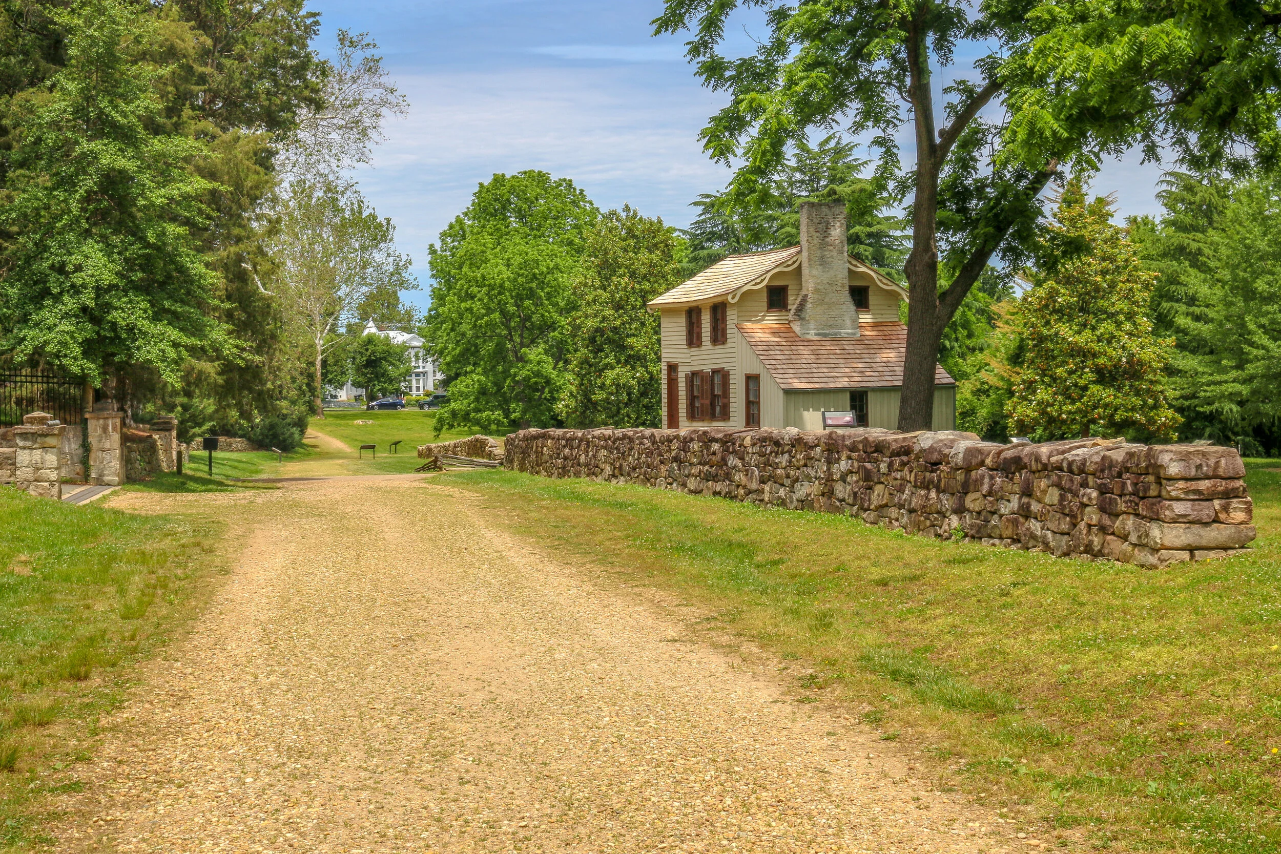
Early’s army crossed the Potomac River into Maryland on the 4th of July, 1864 and marched past Sharpsburg, the site of the Battle of Antietam two years earlier. You can’t march 15,000 infantry troops across a state without anyone noticing, and word quickly got to General Lew Wallace who was then the Union commander in Baltimore. Wallace gathered what men he could muster and quickly set off towards the west. Thinking quickly, Wallace decided to head towards Monocacy Junction, just south of Frederick, Maryland. He didn’t know where the Confederates were headed, but this point would allow his troops to defend the Georgetown Pike to Washington, the National Road to Baltimore and the Baltimore and Ohio Rail Line. If he got there first, he could strategically place his men along the Monocacy River and defend all three of those routes which crossed the river at that point. He arrived in time to dig in and establish a line of defense.
The Battle of Gettysburg which took place from July 1st-3rd, 1863 would be the bloodiest battle of the Civil War. 170,000 men would clash over those three hot days in July and over 50,000 would end up dead, captured, wounded or missing. While both armies were looking for a fight, neither expected it to be in this tiny Pennsylvania town.
After his dramatic victories at Fredericksburg and Chancellorsville, General Lee decided to once again push north into Union territory. He wanted a decisive victory on Northern soil to try and force President Lincoln to the negotiating table. Lee marched his Army of Northern Virginia north, crossed the Potomac River and moved through Maryland and into Pennsylvania. The Union’s Army of the Potomac, still under the command of General Hooker, pursued. By the end of June, General George Meade had replaced Hooker at the helm…
The photos below come from a recent visit to Gettysburg National Battlefield, the site of the bloodiest and most well known battles of the war. Civil War Chronicles will trace the major battles of the Eastern Theater through photos and brief histories
After being turned back south after the Battle of Antietam, Confederate General Robert E. Lee marched his army back to Virginia. Union General George McClellan was replaced by General Ambrose Burnside to command the Army of the Potomac, and President Lincoln urged Burnside to pursue the Army of Northern Virginia deep into the state and attack the Confederate Capital at Richmond. The major obstacle lying in their way was the Rappahannock River.
Burnside arrived at Stafford Heights overlooking the river and the small town of Fredericksburg in mid-November, 1862. He had sent orders to have pontoons at the ready to provide a means of bringing his army rapidly across the river. Tragically for Burnside and his men, the pontoons didn’t arrive for several weeks. Instead of crossing the river in boats or rafts, he chose to wait for the pontoons. By the time they got there, Confederate troops had dug in on the high ground south of the city called Marye’s Heights and behind a stone wall along a sunken road to the front of this position.
Union engineers worked through the night of December 10th to assemble the pontoon bridge, but their progress was slowed by Mississippi sharpshooters in town. A small group of Union soldiers crossed the river in boats and fought a battle to secure the streets of the town. They finally secured the town in late afternoon on the 11th, but it was winter and the daylight soon gave out. The bridge would be completed and most of the army would cross it on December 12th.
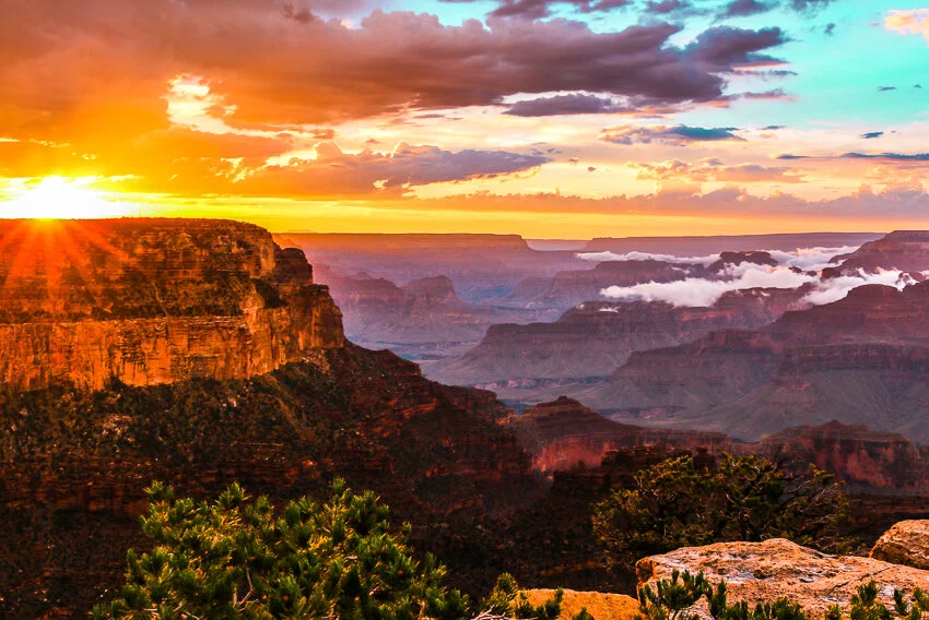
Antietam National Battlefield was the sight of the bloodiest day in American History and one of the best known battle of the American Civil War. Along Antietam Creek just north of the tiny town of Sharpsburg, Maryland, 100,000 soldiers marched into battle on September 17th, 1862. By the end of that day almost 23,000 were dead, wounded or missing.
After a Confederate victory at the 2nd Manassas/Bull Run, General Robert E. Lee pushed into the North for the first time. The Virginia countryside had been ravaged during the first year of the war, and Lee wanted to give it time to heal, plus a decisive victory in the North might bring President Lincoln to the negotiating table.
On September 15th, 1862, Lee crossed the Potomac River into Maryland and dug in along the high ground west of Antietam Creek. Union forces under Commanding General George McClellan moved in from the east. At dawn on September 17th, the battle began…
The photos below come from a cloudy visit to Antietam National Battlefield, the site of the bloodiest day in the American Civil War. Civil War Chronicles will trace the major battles of the Eastern Theater through photos and brief histories.
On July 21st, 1861 the first major battle of the American Civil War took place near the town of Manassas, Virginia and just west of a meandering creek called Bull Run. The battle was supposed to be a quick and decisive one, and many congressmen and socialites rode out from Washington with picnic baskets to watch it unfold. 10 hours after the battle began, 900 young men lay dead on the battlefield and the bloodiest war in American history began in earnest. This first Battle of Bull Run at Manassas was also where General Thomas J. Jackson earned his nickname as General Barnard Bee commented to his men “There stands Jackson like a stone wall! Rally behind the Virginians”. By the end of the day, the Southerners had sent the Federals running back to Washington and won a major victory for the Confederacy.
Just over a year later, the two armies clashed once again near this critical rail junction just 25 miles from Washington D.C. For three days in August, the Battle of Second Bull Run at Manassas raged violently across the landscape. When the smoke cleared, 3,300 soldiers lay dead and the South once again claimed victory. General Robert E. Lee, now in charge of the South’s Army of the Potomac, knew that their breadbasket in Northern Virginia was running low, so he pushed the war across the Potomac River and into the North for the first time. The tides would turn at the battle of Antietam at Sharpsburg, Maryland. To learn about this next chapter in the war, check back for my next installment of the Civil War Chronicles, coming soon.
The photos below come from a cloudy visit to the Manassas National Battlefield, the site of two important battles from the American Civil War. Civil War
Hello everyone, well we’ve made it through another week. I hope it’s been a good one wherever you’re reading this from today. Mine has been really good – probably the best I’ve had since returning home to D.C. now 2 months ago. After a positive start to being sheltered in place and having some free time to catch up on some work and try some fun stay-at-home hobbies, I really hit a downward spiral there for a while as claustrophobia and cabin fever kicked in. With the extended and indefinite closure of my industry (travel and tourism), I found myself staring out at an uncertain and challenging future. I usually keep my anxiety levels in check by being in control of certain aspects of the situation and then allowing the rest to unfold as it will. Under these circumstances, my environment is more controlled than usual, but there are thousands of moving pieces around the world that I have no control over, but which will help shape my near and distant future. I find that to be incredibly frustrating, and with limitations on how I normally deal with my frustration as the gym is closed, travel is limited and my camera is gathering dust.
I’m the kind of person who usually turns inward to sort things out, dealing with them in my own head with little or no outside influence. This week though, I’ve had a lot of outside influences help pull me up out of the mud. First I got some nice messages from some of y’all which is always appreciated. Believe me, I love to hear from you so don’t hesitate to comment or message me. Second, I met with a couple of different friend groups over Zoom which is always good. Third, I went to see some of my friends in person – masked and 10 feet apart, but it was still great to actually see people in the flesh. I hate the fact that I’m home and can’t see my friends or their kids, and this was a chance to at least pop around and say hello. And lastly, my mom came up with a plan to get us out of the house and provide some outlet for being stuck at home indefinitely.
Last Thursday, we went for a walk in Rock Creek Park, the large green space which surrounds its namesake creek through the middle of the city. We took a look at the earthworks that were once Fort DeRussy…
They say a picture is worth a thousand words. In this series I’ve chosen one picture per post which brings out strong memories for me and has a story attached to it. This story is about a beautiful morning along the Nabesna Road in Wrangell-St. Elias National Park, my last morning in Alaska.
It all started with a cigarette.
I haven’t been a regular smoker for many years, but sometimes when I had worked a long season guiding tours and the days were turning cooler as summer turned to fall, I’ve been known to pick up a pack. Usually before that pack is finished I’ll remember why I quit, but those first couple remind me why I started to begin with. And so it was that on a sunny afternoon in early fall I found myself smoking a cigarette outside of my hotel a few miles from LAX International Airport.
This was a hotel we used for our staff during turnarounds between tours in L.A, and there were a few other of our vans than mine in the parking lot that day. A fellow tour leader who I didn’t know had seen me get out of my van, so she came over and introduced herself. We made small talk about what trips we were doing and what else we were up to with a few days off in L.A. and she told me she was filling out an application to return to Alaska to work the following summer. In the company I work for, Alaska is like the Promised Land, it’s somewhere everyone seems to want to go spend the summer, but in the old days it was somewhere you only got to go once. One season in the great north land, and that was it. More recently, she told me, we had started running some high-end tours and they needed some experienced leaders to run them so the application process was open to everyone. We chatted some more, and it got me thinking…
They say a picture is worth a thousand words and as a visual storyteller I usually tell stories through my photos. Since I’ve been sheltered in place though, I haven’t been able to get out and take as many photos as I’m used to. But I was recently reminded that after 20 years on the road, I have a lot of stories to tell. So here’s a crack at some of them. One photo and a thousand words (this is a big story - it’s actually a fair bit longer than a thousand words, but I was never much for rules). So here’s my first crack at this - it’s also a story I tell in Episode 0 of my podcast which you can listen to HERE.
When I was a teenager, I was standing alone one day in the rain, and in a moment of youthful angst I felt overcome with the feeling that I was never going to live to see 30. Through the years I have seen this is a fairly common teenage phenomenon, but I didn't know that at the time. Some of it came from the media, and the exposure to the James Dean and Jim Morrisons and Kurt Cobains of the world. All the cool people died young. And some probably came from anxiety about getting older and watching our youth and vibrancy disappear, becoming more like our parents and teachers. But no matter where it came from, it weighed on me and I set out to live a life with the time that I had, with a sense of purpose and urgency. And I did.
My youthful desires were actually pretty easy to fulfill. At 16, I needed a car and wanted an old Mustang, so I bought a 1968 classic 289. It was a beautiful car!. At 20, I wanted to live at the beach and see what that was like, so during my last two summers in college and for a full year after I graduated, I lived in Myrtle Beach, South Carolina and partied like a rock star. Perhaps most of all though, from the time I was a kid, I wanted to see America. Fulfilling this goal wasn't as easy as the others until, one day, it was. At 24, as I set off on my career running nationwide tours, I saw my dreams become reality. Once I had seen the major American landmarks I had always been enthralled with, I set out into smaller towns and rural communities.
Hello everyone, another week has come and gone and it’s certainly had its ups and downs. More ups than last week, so that is at least something. The weather got warm here in D.C. for the weekend, and we enjoyed sitting outside in the sun. It’s turned significantly colder again as the new week began, which I’m okay with because I know the oppressive heat of D.C. in the summertime is not far away. It’s normally about this time of year that I’m making plans to head north and away from the heat. North to the Rockies, north to Alaska, north to the Great Lakes - somewhere where summer is a little bit easier to cope with and it’s actually a wonderful thing to be outside. I think it’s the knowledge that I’m likely to be here in D.C. for most of the summer which made my cabin fever boil over a bit this week. I miss the road. I miss my friends. I miss the opportunity to pick up and go when and where I want to. I miss new adventures and experiences.
We had a nice weekend here in the old homestead. My mother took charge of the social calendar for a night on Thursday and we enjoyed an evening in a colonial tavern. We had a wonderful meal and listened to some lovely fife and drum music from Colonial Williamsburg. It was a lot of fun and definitely different.
Friday, we had a nice barbecue outside, minus the barbecue. My old gas grill wasn’t working right, so we cooked inside instead, but at least we sat outside and enjoyed the nice weather and some good music…
South Texas was the end of the road for me on this leg of my journey. I set out to make it across the country to the Pacific Ocean and back over the next 16 months or so, but the coronavirus put an end to all of that. When things started going from bad to worse further north, I made my way all the way south to South Padre Island and Port Isabel, stopping off at Palo Alto National Historical Park along the way. The battlefield was awesome to see and I had it almost entirely to myself. I learned a lot about the first battle of the Mexican-American War, and the two future presidents (Ulysses S. Grant and Zachary Taylor) who fought in it. The prickly pears were just starting to bloom, and the day was just on the verge of being too hot to be out in the sun. It was a beautiful and fascinating place. From there I headed to the coast and hunkered down for almost a week. While everything was pretty much shut down, I enjoyed the beach, sand art, peace and quiet and beautiful sunsets on the bay. When Shelter-In-Place orders came down for the beach communities, I knew it was time for me to head home, making this the end of the road for now. I was glad I saw it and had the chance to spend some time in this tiny, far out corner of America.
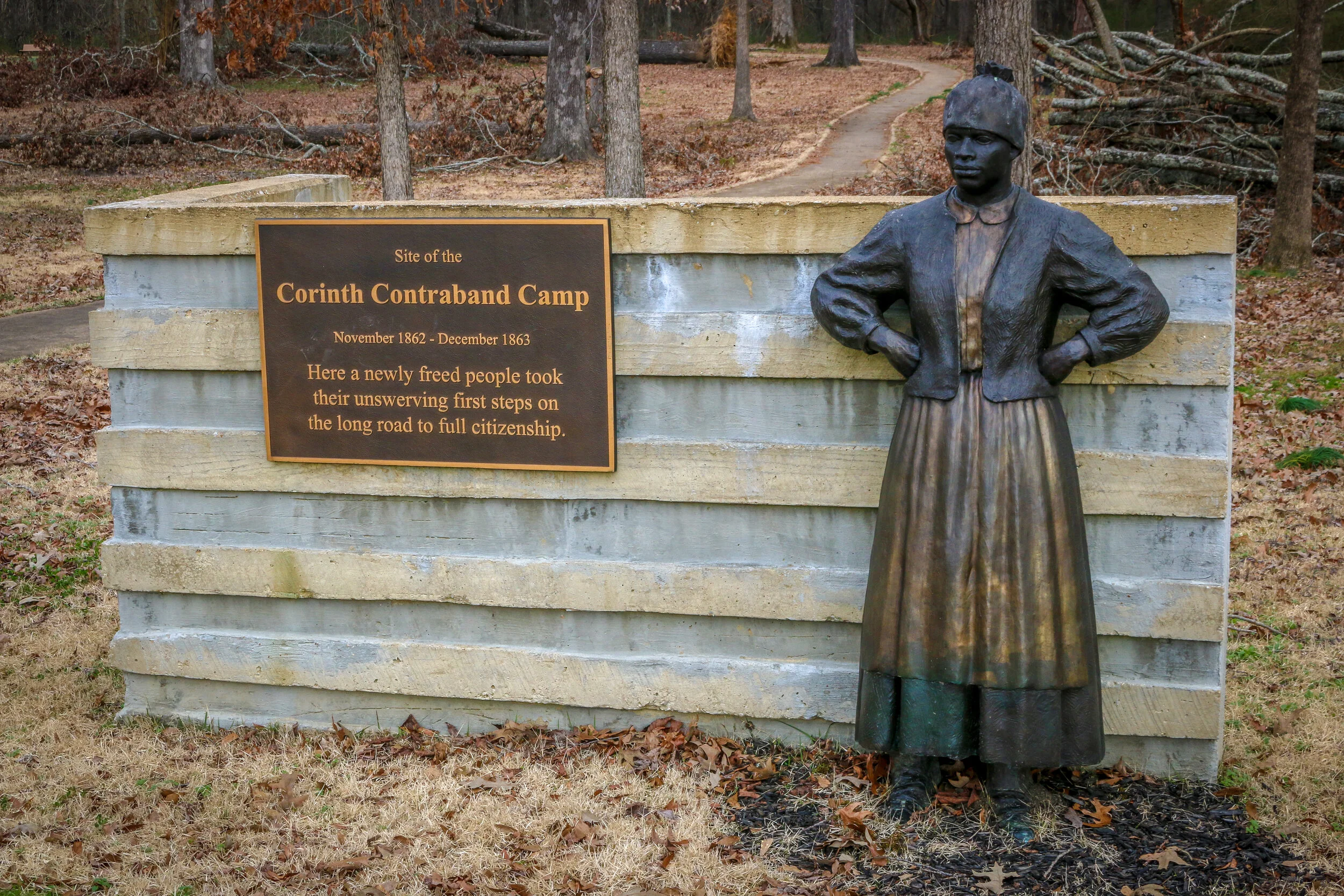
The Corinth Contraband Camp was established in the wake of the Battle of Shiloh and the subsequent occupation of Corinth by the Union Army. Enslaved people in the area fled behind Union lines, seeking safety from their masters with the Union Army. The army saw the strategic value in providing these people a safe haven. The former slaves were put to work to aid the war effort, and were paid for their time and allowed to pursue an education with missionaries who came from the North. They built homes and gardens for food and even planted cotton to aid the Union Army. Many young men who made their way to the camp enlisted in the army – first used as cooks and laborers and later armed as the 1st Alabama Infantry Regiment of African Decent (later the 55th U.S. Colored Troops). These troops were used in combat at Brices Crossroads and Waterford in 1864. The camp was a model for others of its kind springing up across the South. It was the first step for these people on their road to freedom. More than 6,000 people passed through the Corinth Contraband Camp during the year it was operational. The camp was abandoned in 1864 as Union efforts consolidated in Memphis, and not much remains there today. The open site is part of Shiloh National Battlefield, and the wonderful sculptures in these photographs were produced by Larry Lugar, a sculptor from nearby Memphis. I think they are wonderful depictions and show the determination these newly freed people showed under adverse conditions during their time there. It might not have been paradise, but for the first time in any of their lives, they were free.
The Battle of Shiloh took place on April 6th and 7th, 1862 in the woods near the Tennessee River just north of the Mississippi border. The battle takes its name from a log church which was there at the time and built by the settlers in the area. The word ”Shiloh” sadly comes from the Hebrew for “Place of Peace”, but in our history it will forever be remembered as a place of terrible, bloody conflict. The Union was moving down the Tennessee River with the hopes of capturing and controlling the Mississippi River Valley. One of the keys to that goal was the important railroad crossing in nearby Corinth, Mississippi, which linked the Mississippi and Charleston and the Mobile and Ohio Railroads. The first was the only rail link between the Mississippi River and the Atlantic Ocean. After a decisive victory at Fort Donelson and the subsequent falls of Nashville and Clarksville, the Union Army set their sights on Corinth, and the Confederacy rushed to reorganize and defend it…