Hello Everyone,
It’s been a hot week here in Montana. Two weeks ago it was snowing in Butte and two days ago we were hitting record high temperatures across the state. It’s been dangerously hot out, especially since I have no air conditioning in my van. I’ve been holed up here in Livingston for a few days and spent the last two nights in a nice, air conditioned hotel room. It was a nice break from the road and from the heat, but it’s frustrating to feel penned in and not be able to go exploring. It’s been a tough summer so far, and the heat is not making things any easier. I’m much better at dealing with the cold than dealing with the heat and my van is the same. That being said, I did get out and see some cool places this week and I’m very grateful to have some friends to hang out with this week, as that really makes a big difference in my morale. The heat should break in the next day or two, and then hopefully it will be a little easier going.
So after I finished up this post last week, I meandered down to the little local history museum there in Great Falls. It was a cute little museum with some interesting exhibits on the history of Great Falls, one called Spirits of Cascade County: Bootlegging, Bureaucracy, and Breweries, and one about feisty Montana women (their words, not mine). There were some cool bronze sculptures and some neat miniature building models as well. They also had a really interesting exhibit in what must have been some sort of event space on the historic Ozark Club, a black owned nightclub which had opened in Great Falls the day that prohibition ended and lasted until the owner’s death. After a nice visit to the museum, I did return to the Sip ‘n Dip Lounge to watch the mermaid in her pool behind the bar. Their tiki drinks were not very good, but the show was fun and I really enjoyed being there. Leaving the lounge, I wandered around downtown a bit and then called it a night.
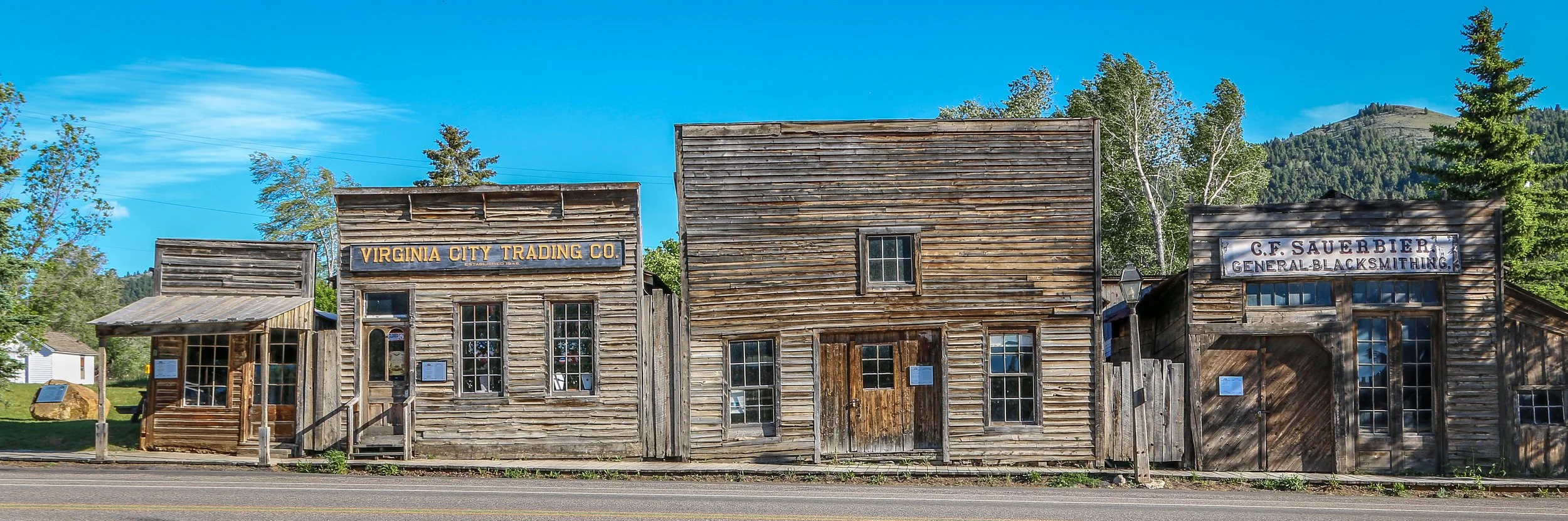
Gold was discovered in nearby Alder Creek in 1863, sparking off one of Montana’s biggest gold rushes. People came from far and wide to try and earn their fortune in what is now southwest Montana. Soon after the discovery, a mining district was established and was named Verina [sic] after Confederate President Jefferson Davis’ wife, Varina. In the midst of the Civil War, this couldn’t be allowed, so the name was changed to Virginia City. When Montana Territory was carved from the existing Idaho Territory in 1864, Bannack was chosen as the capital, but the capital was moved to Virginia City just a year later. Virginia City would remain the capital for a decade before it was moved again to Helena. In the early days, a road gang called The Innocents was preying on wagons moving between the mining towns. In response, Virginia City residents formed The Montana Vigilantes who rode on The Innocents and lynched them in the streets of nearby Bannack. Virginia City is considerably quieter these days. With some lovely shops, some good restaurants and a couple of bars, including Montana’s oldest the Bale of Hay Saloon, Virginia City is a wonderful place for a wander. I hope you enjoy these photos from the cool, historic town of Virginia City, Montana’s second territorial capital.
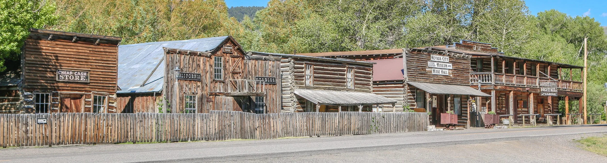
Gold was discovered in Alder Gulch in 1863 and Nevada City sprung up almost overnight. It was a true boom and bust mining town which may have grown to as many as 2,000 residents but would dwindle down to only a hundred by the end of the decade. By 1880, the population was down to 50 and it would continue to shrink until Nevada City was all but a ghost town. In the 1950s, former state senator Charles Bovey decided to revive the old town as an outdoor living history museum. He salvaged a dozen or so buildings which were original to the townsite and then started bringing in other historic buildings from around the state. Today, Nevada City is owned by the State of Montana and managed by the Montana Heritage Commission. I unfortunately arrived after it had closed down for the night, but there was still plenty to see from the street. I’ll definitely have to get back and explore it another time. I hope you enjoy these photos from historic Nevada City - where Montana history comes to life.
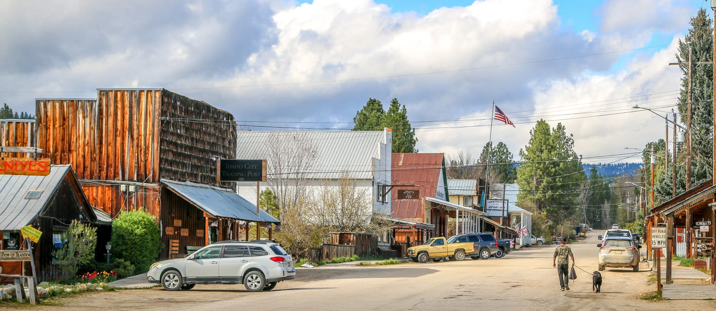
Gold was discovered in the Boise Basin on August 2, 1862 by a prospecting party led by George Grimes. After Grimes met an untimely end, the rest of his party made a quick exit from the area. Prospectors returned the following spring and the search for gold began in earnest, with settlements springing up throughout the region. The town of Bannock City was among them, a town which would later be renamed Idaho City after the Territory of Idaho was established in 1863. During its heyday, Idaho City was the largest city between St. Louis and San Francisco, even outgrowing Portland. It was known as “The Queen of the Gold Camps” and it was often said that the streets of Idaho City were paved in gold (although in reality they weren’t paved at all). Two years after its founding, Idaho City burned to the ground, losing 80% of its buildings in the flames. The town would quickly rebuild, only to suffer another devastating fire just a few years later. This time, wooden buildings were rebuilt with brick. Over $300 million dollars worth of gold was pulled out of the Boise Basin, which would be several billion dollars today. As the gold played out, the miners departed for other strikes in other places. Today, Idaho City has a year-round population of around 500 people. There are some great old buildings around town, beautifully preserved. Of note are the oldest Catholic church, Masonic Hall and Odd Fellow’s Hall (I.O.O.F.) in the state, all of which are still in use today. There’s a fantastic old two story schoolhouse which now serves as the City Hall and Idaho’s old territorial prison. Idaho City is a quiet town and I really enjoyed all of the old buildings and gold rush history. I hope you enjoy these photos from Idaho City, where the streets are (definitely not) paved in gold.
I have really been looking forward to visiting Ferndale, the Victorian village in Humboldt County, and it was so much more than I ever imagined it would be. This charming town is over the river and down the road from the main highway and while it’s definitely not a secret it still kind of feels like it is.
Ferndale got its start back in 1852 when brothers Stephen and Seth Shaw came to the area to claim a homestead and begin farming. They found that the land was particularly suitable to raising cattle and a small dairy community would begin to grow. William would eventually leave the area, but Seth remained and built a beautiful Gothic home, which he called Fern Dale. When a post office opened in the area, the name was adopted for the town. That house is now called Shaw House and is still there to see in all its Gothic glory.
Dairy, and especially butter, would be the main industry of the town for quite some time, and a process of cutting and wrapping butter in paper for transport was pioneered in Ferndale. Once this process had been developed, butter was shipped down the Eel River and sent south to San Francisco and the town would grow. Butter brought wealth to the area and many fine homes and buildings were constructed in the Victorian style of the time, often called “Butterfat Palaces”. I’m thrilled that so many of these buildings have survived and dairy continues to be the main industry driving the local economy.
I spent a couple of days in Ferndale, taking these photos. I found the locals to be friendly and welcoming as one would expect in Northern California. I particularly enjoyed a conversation about the upcoming Humboldt County Fair one night in the Palace Saloon and also attending an Old Timers’ baseball game at the local ballfield. Breakfast at Joe’s Place was top notch and I loved being able to enjoy a glass of local wine above the bar in the Gazebo. Taking these photos was a joy, especially of the Gingerbread House, Gazebo, the Victorian Inn and the beautiful lamp posts around town. I hope you enjoy these photos of fabulous Ferndale, a town full of Victorian charm in the heart of Humboldt County…
Vitus Bering claimed Alaska for the Russian Empire in 1741 under orders from Tsar Peter the Great. Russia’s hold on Alaska would last until they sold the territory to the United States in 1867 and their primary focus was on the abundance of valuable furs found in Alaskan waters. The most enduring legacy of Russian culture in Alaska is the strong presence maintained by the Russian Orthodox Church in the state. This summer I had the pleasure to visit these four beautiful Russian Orthodox churches, three in the Kenai Peninsula and one in Anchorage. As someone born into and raised in the Russian Orthodox faith, I found it fascinating to visit these churches and I was thrilled (or, perhaps, blessed) to see them all on sunny days. I hope you enjoy my photos.
Construction on Fort Bowie began in 1862 after two separate confrontations between the United States Army and the Chiricahua Apache. The fort was erected to protect the Apache Pass through the mountains and Apache Springs, a vital water source in the area. Six years later a more substantial fort was built just up the hill from the original fort and would be in service until 1894. The Apache Wars would end in 1886 with the surrender of Chiricahua leader, Geronimo, and the removal of the Chiricahua from the area. As you may remember from a recent post, the U.S. Army was aided in this endeavor by the White Mountain Apache scouts based in Fort Apache to the north who were the sworn enemies of the Chiricahua.
The fort today is a mere remnant of what it once was. The adobe walls have all but melted back into the surrounding desert and the stone foundations and a few odds and ends are all that is left. This park is unique in that it is a “hike-in” park, meaning the only way to visit it is by hiking the 1.5 miles from the parking lot up to Apache Pass. This walk takes you past the old stagecoach stop ruins, the cemetery, an old Apache village, Apache Spring and up to the pass where the fort is located. While the rangers at the park will provide access for people with disabilities, this walk is an amazing way to get a feel for the remoteness of the fort and the isolation the men who were once stationed there must have felt. I was definitely glad I visited in the winter months as I’m sure making this walk in the summer is quite hot and dusty. I was definitely glad I finally made it out to Fort Bowie as it’s been on my to-do list for many years now and I’m glad I finally got there. I hope you enjoy these photos from Fort Bowie National Historic Park.
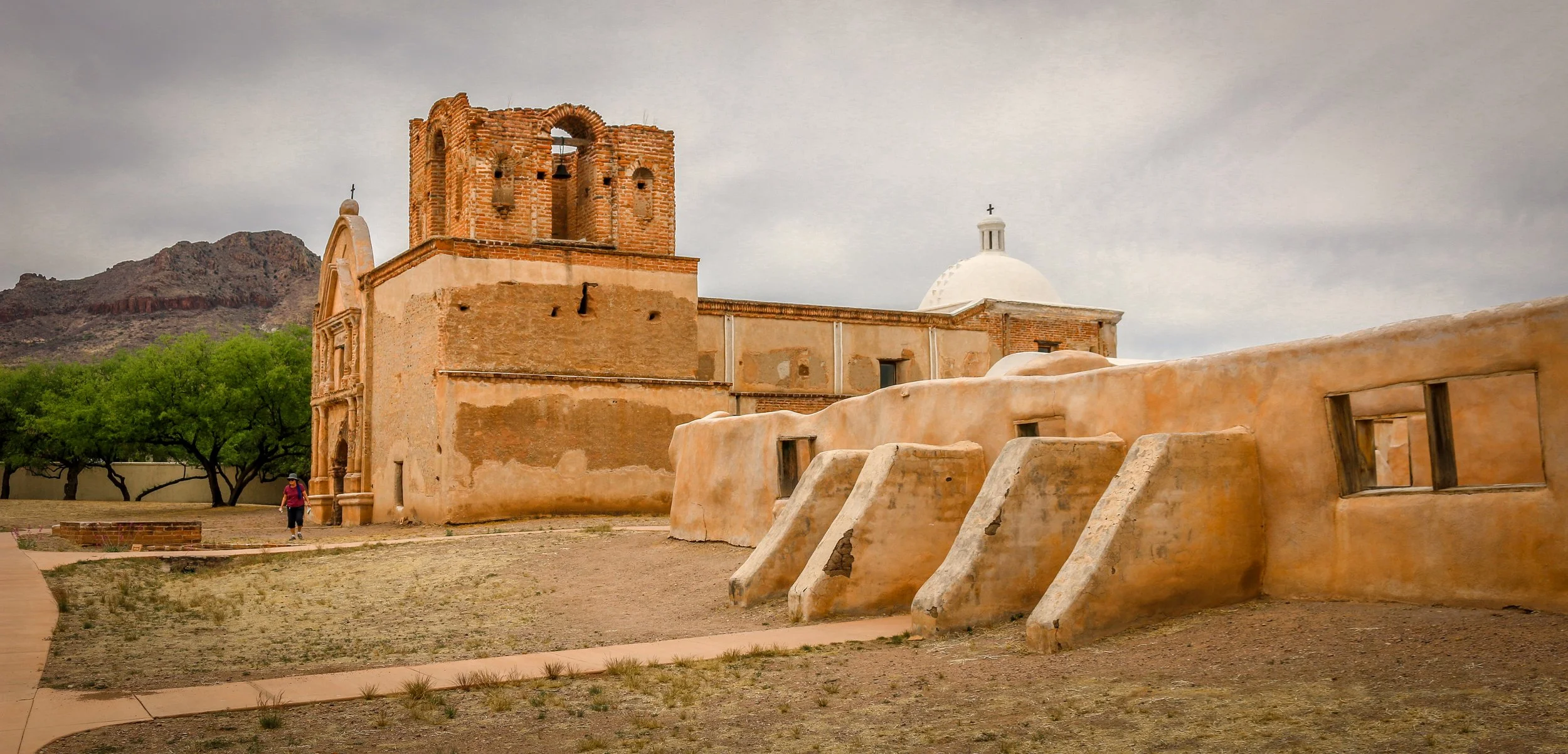
Father Eusebio Francisco Kino established the Mission San Cayetano de Tumacácori on the east side of the Santa Cruz River in January of 1691, making this the oldest mission site in what is now Arizona. The name “Tumacácori” is an English bastardization of a Spanish interpretation of an O’odham (Pima) word, the meaning of which has been lost. It is how the native people referred to this region. After years of violence at the hands of the Spanish, the O’odham people rose up in the Pima Revolt of 1751. Laying blame on the abuse of the Jesuits missionaries, they were pardoned by the colonial governor and the Jesuits would be expelled from the colonies beginning in 1757. The mission was moved across the river and renamed Mission San José de Tumacácori and the first actual church was built on this new site.
Franciscans would try and pick up where the Jesuits left off and in 1800 they began work on an ambitious new church, trying to match the majesty of Mission San Xavier del Bac to the north (a photo of which appears at the very bottom of this post). The church was never fully completed as the missions were closed when the Mexicans won their independence in 1821. Today, the mission is a part of Tumacácori National Historical Park and a visit is a must when you’re in the area. You can learn more about the O’odham people, the Spanish missionaries and colonial life in the missions and it’s a very cool place for a wander.
The area that is now Tucumcari was once home to dinosaurs who walked the shores of an inland sea. When the water receded, the sediment formed into sandstone and one of the formations it left is now called Tucumcari Mountain (although it’s really more of a mesa). Prehistoric people tracked mammoths and mastodons in the area and later developed farming techniques and built villages. In the 18th century, the Apache and Comanche moved through the area, hunting bison and pronghorn. The name, Tucumcari, comes from an Apache word “tukanukaru,” meaning “to lie in wait for something to approach”. In the early 20th century, the Chicago, Rock Island and Union Pacific Railroad was making its way across the country and a tent city sprung up called Ragtown and, later, Six Shooter Siding. As the camp grew into a town, they changed the name to Tucumcari and it stuck. Route 66 came through in 1926 and the town became an overnight stop for people headed west. Signs for miles declared “Tucumcari Tonight” and people pushed through for the promise of a hot meal and a comfortable bed. Tucumcari today still capitalizes on nostalgia for the “Mother Road”, but also has a wonderful museum downtown which has a place for everything and everything has been lovingly put into place. I had a great stop in Tucumcari and definitely got my kicks on Route 66. I hope you enjoy these photos from beautiful Tucumcari, New Mexico.
After the Treaty of Guadalupe Hidalgo ended the Mexican-American War in 1848, New Mexico officially became a part of the United States. Americans started moving west to try and stake a claim in this new territory, but were often met with hostility by Indians trying to protect what they believed belonged to them. In response, the U.S. government built Fort Union at the main junction on the Santa Fe Trail. The original fort was good enough for that purpose, but a second, stronger, fort was built during the Civil War and a third fort soon replaced the second. The fort served two main purposes which were independent of each another - one being a military post and the other, a quartermaster depot. The depot was the supply hub for the government in the southwest and received hundreds of wagonloads of supplies daily to support 46 regional posts. There was also an arsenal on the base which could have also been seen as a separate entity as it had its own commander and staff. In addition, the base hospital provided the best medical care for hundreds of miles around. Fort Union served as the jumping-off point for Union forces on their way to fight at Glorieta Pass, the last Civil War battle fought in New Mexico. After the Civil War, African-American soldiers with the 57th U.S. Colored Infantry arrived at Fort Union and later the 9th U.S. Cavalry, remembered today as the Buffalo Soldiers, would join them. When trains started rumbling across the country at the end of the 19th century, Fort Union became obsolete and was decommissioned in 1891. The last soldiers left on May 15th of that year. In 1954, it became Fort Union National Monument and its history is now interpreted by the National Park Service.
Most of the fort was built of adobe which, without regular maintenance, will melt back into the desert. Some exceptions were the stone jail and the brick chimneys which provide a glimpse into what Fort Union once was. This park site doesn’t get many visitors, but it’s a fascinating place to learn about the Santa Fe Trail and early American history in the New Mexico Territory. I hope you enjoy these photos from fascinating Fort Union National Monument.
“The Original Las Vegas” was founded along the Galinas River in 1835 in the midst of Mexican rule in the area and quickly grew as a popular stop on the Santa Fe Trail. It was on the Plaza in Las Vegas where Stephen Watts Kearny claimed New Mexico for the United States during the Mexican-American War in 1846. In 1879, the Atchison, Topeka and Santa Fe Railroad came to Las Vegas and the town quickly grew into one of the largest in the region. The New Mexico Normal School (now Highlands University) was established in 1893 and Fred Harvey built the Castañeda Hotel in 1898 as part of his hospitality empire in the southwest. Las Vegas hosted Teddy Roosevelt’s Rough Riders’ first reunion in 1899, a tradition that continued for many years. In more recent years, Las Vegas has been the filming location for many movies including No Country For Old Men, Wyatt Earp (with Kevin Costner), and perhaps most notably for me, Red Dawn where it served as the fictional town of Calamut (the massive “Calamut Says Howdy” mural is still a prominent feature downtown). I found Las Vegas to be a quiet, charming University town with some spectacular architecture, fascinating history and friendly people. It may be the “other Las Vegas”, but it’s a town not to be missed on your travels in New Mexico. I hope you enjoy these photos from wonderful Las Vegas, New Mexico.
The homes we now refer to as the Gila Cliff Dwellings were built beginning around 1276. The rivers in the area provided a constant source of water, a necessity in the desert and probably the reason the people who built these dwellings chose this location. While they were contemporaries of the people we now call the Ancestral Puebloans, differences in their construction styles, pottery and art have caused archaeologists to give them a different name and we refer to them as the Mogollon. The time that the Mogollon spent in these dwellings, approximately 25 years, coincides with prolonged drought in the area which caused many groups to move in search of water. It seems that the Mogollon moved into these alcoves near the beginning of the drought, and left as it was ending. When looking at history, it’s easy to think of 25 years as the blink of an eye, but it’s a whole generation of children growing to adulthood and having their own babies and adults moving into the roles of elders as elders pass on. There was love and loss and laughter as this group passed the time farming, hunting, building, creating and growing.
The Mogollon seem to have moved on around 1300 as the drought was coming to its end and these isolated dwellings likely remained empty for quite some time. The Chiricahua Apache migrated to the region in the 1500s and the great leader Geronimo was born near the headwaters of the Gila River around 1820. Spanish settlers came to the area in 1598, but there is no evidence they penetrated the wilderness anywhere near to the dwellings. Prospector H.B. Ailman documented the cliff dwellings in 1878 and by the time archaeologist Adolph Bandelier arrived in 1884, looters had ransacked the alcoves and made off with whatever artifacts were to be found. Homesteaders, miners, prospectors and ranchers arrived over the next few decades and President Theodore Roosevelt protected the area as Gila Cliff Dwellings National Monument in 1907. Not too long after he did, Aldo Leopold came to the region as a forester and lobbied the Forest Service to establish the GIla Wilderness, the first designated wilderness area in the country and an inspiration for the 1964 Wilderness Act.
Today, the Gila Wilderness is a quiet and magical place. It’s a two hour drive from Silver City, the nearest town of any real size, to the Cliff Dwellings. The road that brings you in is the aptly named Trail of the Mountain Spirits National Scenic Byway and it is a truly beautiful drive. During my visit, I toured the cliff dwellings, scouted out some beautiful pictographs, hiked the fabulous Little Bear Creek Canyon trail to the Middle Fork of the Gila River and soaked in wonderful hot springs. I loved my time in the Gila Wilderness and hope you enjoy these photos from my visit.