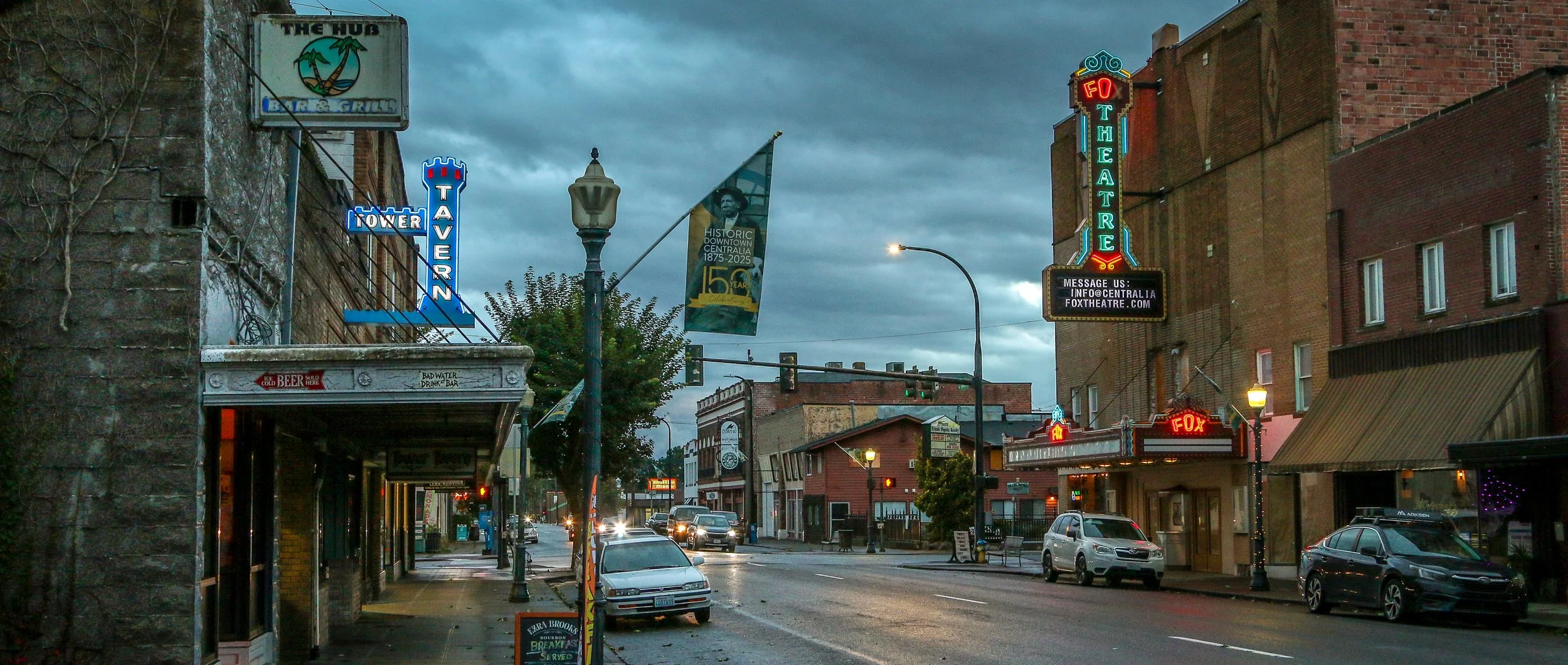
I came to Centralia to enjoy a night in the storied Olympic Club - a century old private men’s club turned hotel and bar. The beautiful, old mahogany bar, enormous woodstove, leaded glass fixtures and spacious pool room were all I imagined them to be and more and I definitely recommend a visit. But there was more to Centralia than the club. I found some great neon signs, a cool old theater, some colorful businesses, friendly locals and one of the prettiest tower clocks I’ve ever seen (so pretty I included day and nighttime photos below!).
This area was originally home to the Upper Chehalis people and settlers started arriving down the Oregon Trail in the mid 19th century. One of the original non-native settlers was a free Black man named George Washington who arrived in 1850 with his adoptive parents. Washington is remembered as the founder of Centralia and in 2023 his birthday was officially designated as Centralia’s Founder’s Day. When a road was built, it became the central stopping point on the stagecoach route between Tacoma and Kalama. When the Northern Pacific Railway came through in 1872, a town started to take shape and chose the name Centerville to denote its central location. A few years later, the townspeople worried they would be confused with another Washington town of the same name, so they changed their name to Centralia. It’s had its ups and downs since, but Centralia is still hanging on. Trains still come through town and it’s still a halfway stopping point, but now between Portland and Seattle. If you’re ever passing through on Interstate 5, stop through Centralia for a beer at the Olympic Club and stay for some classic Americana in Hub City. Enjoy these photos from beautiful Centralia, WA.
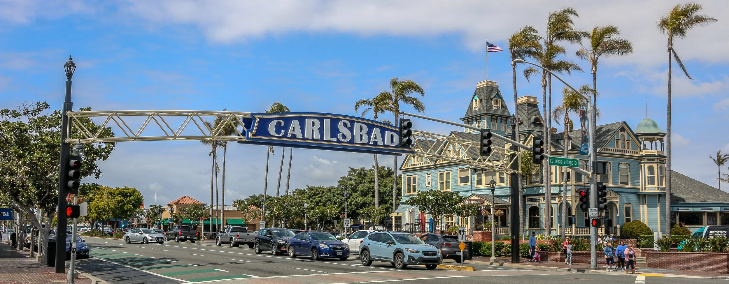
Located right on Highway 101 between Los Angeles and San Diego is the gorgeous little city of Carlsbad. As you drive down the highway, you can’t help but notice the beautiful Twin Inn on the inland side of the road. It’s the kind of building that just sparks your interest, especially a block from the beach in Southern California. The Inn was built by Civil War veteran Gerhard Schutte in 1887. Schutte and his partners laid out the townsite of Carlsbad as “a town of small farms and gracious homes”. They sold plots at $40/acre and the town grew from there.
This area was originally inhabited by the Payómkawichum and Kumeyaay people who enjoyed the bounty of the sea and the fresh water provided by Buena Vista Creek. When the Portola Expedition came to California in 1769 they camped on Buena Vista Creek and mingled and traded with the native people. During the Mexican period, the area that is now Carlsbad was part of Rancho Agua Hedionda which wasowned by Juan María Marrón.
In the early 1880s, a man named John Frazier dug a well and served up water to thirsty train passengers on their way through. It turned out that the water was quite special and the area became known as Karlsbad after a famous Bohemian spa town. Enter Gerhard Shutte and his Carlsbad Land and Mineral Water Company which laid out and promoted the town as mentioned above.
Today, Carlsbad is a pleasant, medium sized city of about 114,000 people. I really enjoyed walking around on a beautiful, sunny spring day to take these photos. The old train station has been converted into the town’s visitor center and the Twin Inn has been incorporated into the Village Faire shopping area. I also loved the many old and quirky buildings I found as I made my way around the city center and the modern parts of Carlsbad have been tastefully added to enhance the city’s beauty. There are plenty of beautiful murals around and some great shops and restaurants as well. I’m so glad I stopped in to see Southern California’s stunning Village by the Sea. I will definitely be back to visit again in the future. I hope you enjoy these photos of beautiful Carlsbad, California.
There may be no more iconic plant in the United States than the stately and stoic saguaro cactus. These beautiful cacti can grow up to 40’ tall and live to be 150 years old. They won’t start growing arms until they are 75 years old and some will grow many arms in their lives. Most of the natural habitat of the saguaro is in the Sonoran Desert which straddles the U.S./Mexico border.
In 1933, President Herbert Hoover designated Saguaro National Monument which we now call the Rincon Mountain District of the park. In 1961, John F. Kennedy added the Tucson Mountain District to the Monument and in 1994 these two tracts were combined into Saguaro National Park.
Whenever I am driving to a new town and I don’t have a specific destination in mind, I just put the town name into my GPS and it usually brings me to either the courthouse or City Hall. Wherever it leads me is usually in the center of town and I can sort myself out from there. You can imagine my surprise, then, when I was approaching Bisbee, Arizona and I turned onto Erie Street and found myself not in the center of town, but somewhere in the 1950s. It was quite surreal to drive up the street and see nothing but classic cars, vintage gas stations and old signs with no streetlights burning and not a person in sight. My GPS told me I had reached my destination but my mind was telling me otherwise. It turned out that it had indeed led me to Bisbee’s City Hall, but that building was situated in the midst of a wonderful local art/history instillation called the Lowell Americana Project which commemorates small-town life in the 1950s.
The Lowell & Arizona Copper Mining and Smelting Company began operation way back in 1899 under the leadership of Frank Hanchett, who named his business after his hometown of Lowell, Massachusetts. Three years later, the mine would be incorporated into the Copper Queen Consolidated Mining Company. Two years after that, the town of Lowell was laid out to house local miners and their families and Erie Street became the commercial center. In 1908, Lowell was annexed into nearby Bisbee and the population would grow to 5,000 people. From what I’ve read it sounds like it was a bustling community and a pleasant place to live.
That would all start to change in 1950 when the Lavender Pit Mine was opened and the community’s population had to sell their homes and move out…
Rio Grande del Norte is one of our more recent National Monuments, having been designated as such in 2013. It protects the confluence of the Red River and the Rio Grande which are both designated Wild and Scenic Rivers. Both gorges are gorgeous and the point of land above the confluence, called simply El Punto, provides amazing views from high above the two rivers. I hiked the Little Arsenic Trail while I was there, which brought me down to the Rio Grande and led me straight to the confluence. It was one of the better hikes I did during my stay in New Mexico and was very rewarding around every turn. I spent the night at the campground on the canyon rim and enjoyed a beautiful sunset in the evening and a magical sunrise the following morning. In between, the stars were spectacular. I debated whether to drive out to this park as it was somewhat out of the way, but I’m sure glad I did as it is stunning from end to end. If you’re ever in the area, you should as well. I hope you enjoy these photos from beautiful Rio Grande del Norte National Monument.
Nara Visa, New Mexico got its start as a rail town when the Chicago, Rock Island and Pacific Railroad was being built around the turn of the 20th century. It was originally called Narvaez after a local family who had farmed in the area for decades, but was eventually anglicized to some degree to Nara Visa. Within a decade, the town had grown to include 4 churches, 8 saloons, a couple of hotels and a whole array of small businesses. In 1921, with a growing population of 651, a fine school was built and the Works Progress Administration helped add a gymnasium a decade and a half later. The depression took its toll on the town though and lean years were ahead for Nara Visa. By 1968, there were only 7 students enrolled at the school when it closed its doors for the last time. Today less than a hundred people call the town home, and none of the businesses from this once thriving little community are open. It’s easy to pass through Nara Visa and not see it at all. I’m glad I got out and had a look. It makes me sad when towns die, but the reality is that everyone leaves at some point, one way or another. It looks like times were good there once, and maybe will be again at some point in the future. It sure made for some nice photos though. I hope you enjoy these photos from Nara Visa - a modern day ghost town in eastern New Mexico.
“The Original Las Vegas” was founded along the Galinas River in 1835 in the midst of Mexican rule in the area and quickly grew as a popular stop on the Santa Fe Trail. It was on the Plaza in Las Vegas where Stephen Watts Kearny claimed New Mexico for the United States during the Mexican-American War in 1846. In 1879, the Atchison, Topeka and Santa Fe Railroad came to Las Vegas and the town quickly grew into one of the largest in the region. The New Mexico Normal School (now Highlands University) was established in 1893 and Fred Harvey built the Castañeda Hotel in 1898 as part of his hospitality empire in the southwest. Las Vegas hosted Teddy Roosevelt’s Rough Riders’ first reunion in 1899, a tradition that continued for many years. In more recent years, Las Vegas has been the filming location for many movies including No Country For Old Men, Wyatt Earp (with Kevin Costner), and perhaps most notably for me, Red Dawn where it served as the fictional town of Calamut (the massive “Calamut Says Howdy” mural is still a prominent feature downtown). I found Las Vegas to be a quiet, charming University town with some spectacular architecture, fascinating history and friendly people. It may be the “other Las Vegas”, but it’s a town not to be missed on your travels in New Mexico. I hope you enjoy these photos from wonderful Las Vegas, New Mexico.
In 1598, Juan de Oñate y Salazar was on a conquest to colonize Nuevo Mexico for Spain. Traveling north of El Camino Real, his caravan had just passed through the dreaded 90 mile stretch known as the Journada del Muerto or “Journey of the Dead Man” when they encountered the Piro people of the Tempana Pueblo. These people offered the party food and water and Oñate called the place “Socorro” meaning succor or aid. In 1626, the Spanish built a mission church nearby and christened it Nuestra Señora del Perpetuo Socorro or Our Lady of Perpetual Succor. The mission was abandoned and destroyed during the Pueblo Revolt of 1680 and wouldn’t be resettled until 1815. A beautiful new church was built and named after San Miguel.
I came to Socorro because it was where I was when I ran out of steam for the day. It was on my radar, but I didn’t know if I would have time to stop. I’m sure glad I did. There are so many wonderful historic buildings around town, and the evening was absolutely perfect for photography. I enjoyed a nice long walk around downtown and then settled into the mining-era Capitol Bar for a couple of their house-brewed beers. Then I ventured out to El Camino Restaurant and Lounge, a holdover from another time. Both the restaurant and the lounge are worth visiting for the ambiance alone. It snowed overnight and while there wasn’t much on the ground, the mountains had a lovely dusting. I happily snapped a few more shots with the snow before hitting the road. Socorro is definitely worth a stop on your way through New Mexico and I hope you enjoy these photos from my brief time in this wonderful little town.
People have been visiting the natural hot springs in the Palomas Basin for centuries. The Spanish called them Ojo Caliente de Las Palomas and the cowboys called them Palomas Hot Springs. In the late 18th century, a public bath was built on a ranch in the area where people could come and take the waters. When the Elephant Butte Dam was built in 1912 to help with irrigation, the area became more attractive to settlers and the town of Hot Springs, New Mexico was incorporated in 1916. Twenty-one years later, it would become the county seat of Sierra County. In 1950, Ralph Edwards, the host of the popular radio show Truth or Consequences, promised to air their 10th anniversary show live from any town that would change its name to match that of the show. Hot Springs residents jumped at the opportunity and officially changed its name to Truth or Consequences. Edwards made good on his promise and visited the town on the first weekend of May every year for the next 50 years. His visit was turned into a celebration, Fiesta, which still happens every year at that time. T or C, as the locals call it, is a wonderful and colorful little town full of hot springs resorts and art galleries and with a backdrop of beautiful mountains that light up when the sun is low in the sky. I loved my brief stay in one of the country’s most uniquely named towns, and I hope you enjoy these photos of fabulous Truth or Consequences.
The homes we now refer to as the Gila Cliff Dwellings were built beginning around 1276. The rivers in the area provided a constant source of water, a necessity in the desert and probably the reason the people who built these dwellings chose this location. While they were contemporaries of the people we now call the Ancestral Puebloans, differences in their construction styles, pottery and art have caused archaeologists to give them a different name and we refer to them as the Mogollon. The time that the Mogollon spent in these dwellings, approximately 25 years, coincides with prolonged drought in the area which caused many groups to move in search of water. It seems that the Mogollon moved into these alcoves near the beginning of the drought, and left as it was ending. When looking at history, it’s easy to think of 25 years as the blink of an eye, but it’s a whole generation of children growing to adulthood and having their own babies and adults moving into the roles of elders as elders pass on. There was love and loss and laughter as this group passed the time farming, hunting, building, creating and growing.
The Mogollon seem to have moved on around 1300 as the drought was coming to its end and these isolated dwellings likely remained empty for quite some time. The Chiricahua Apache migrated to the region in the 1500s and the great leader Geronimo was born near the headwaters of the Gila River around 1820. Spanish settlers came to the area in 1598, but there is no evidence they penetrated the wilderness anywhere near to the dwellings. Prospector H.B. Ailman documented the cliff dwellings in 1878 and by the time archaeologist Adolph Bandelier arrived in 1884, looters had ransacked the alcoves and made off with whatever artifacts were to be found. Homesteaders, miners, prospectors and ranchers arrived over the next few decades and President Theodore Roosevelt protected the area as Gila Cliff Dwellings National Monument in 1907. Not too long after he did, Aldo Leopold came to the region as a forester and lobbied the Forest Service to establish the GIla Wilderness, the first designated wilderness area in the country and an inspiration for the 1964 Wilderness Act.
Today, the Gila Wilderness is a quiet and magical place. It’s a two hour drive from Silver City, the nearest town of any real size, to the Cliff Dwellings. The road that brings you in is the aptly named Trail of the Mountain Spirits National Scenic Byway and it is a truly beautiful drive. During my visit, I toured the cliff dwellings, scouted out some beautiful pictographs, hiked the fabulous Little Bear Creek Canyon trail to the Middle Fork of the Gila River and soaked in wonderful hot springs. I loved my time in the Gila Wilderness and hope you enjoy these photos from my visit.
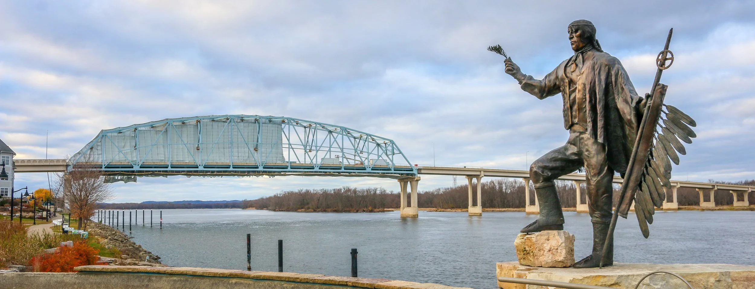
When Europeans first made their way up the Mississippi River, these lands were occupied by the Mdewakanton Dakota people who were led by Chief Wa-pa-shaw. The area was settled in 1826 and officially recognized after the Treaty of Prairie du Chien was signed in 1830. The fledgling town was named after the Chief as “Wabasha” and is now one of the oldest towns on the Upper Mississippi River. The early town’s economy was based on shipping, trading, lumber and flour and there was also a clamming industry and a button factory which utilized the discarded clam shells. Today, Wabasha is still undeniably a river town, but has made tourism a major economic interest - especially with the addition of the National Eagle Center. It’s probably most famous in recent times as the setting, though not the filming location, of the movie Grumpy Old Men. All of that being said, it would be easy to just blow on past Wabasha as it is just a small town of 2,500 or so people, but you’d be missing a real gem on Minnesota’s stretch of the mighty Mississippi. The historic buildings, the awesome statue of Chief Wabasha and the beautiful river setting combine with friendly people and some wonderful small businesses to make Wabasha a charming destination. Be sure you stop by Hoppy Girl Brewing Company while you’re there to taste some of the state’s best microbrews in one of its smallest and friendliest breweries. I had a wonderful visit to Wabasha even though the winter skies were definitely telling me it was time to head south. The next time I find myself in Minnesota, though, it will definitely be on my list of places to return. I hope you enjoy these photos from tiny Wabasha, Minnesota - a true hidden gem on the Mississippi River.
Red Wing was definitely one of the nicest towns I visited during my entire stay in Minnesota. It’s a beautiful historic city of about 16.000 right on the Mississippi River and the Great River Road. Before European settlement, this was Dakota territory and the town takes its name from Mdewakanton Dakota leader Tatankamani, whom Europeans referred to as “Red Wing”. As settlers came west, the Mississippi River was a major transportation corridor, and many people disembarked at Red Wing to begin their new lives on the frontier. A town sprang up and early industries included mills and tanneries. In 1905, Charles Beckman began crafting leather work shoes for the miners, loggers and farmers in the region, and Red Wing Shoes was born. Red Wing Shoes is still headquartered in the town and many of their brands are still produced there, contributing heavily to the local economy. Red Wing has some beautiful, historic architecture and many wonderful art displays around town. While I was there on an overcast, fall day I still found the city to be charming and extremely photogenic. It’s definitely a town I will return to in the future. I hope you enjoy these photos from beautiful Red Wing, Minnesota, an historic town on the banks of the mighty Mississippi River.