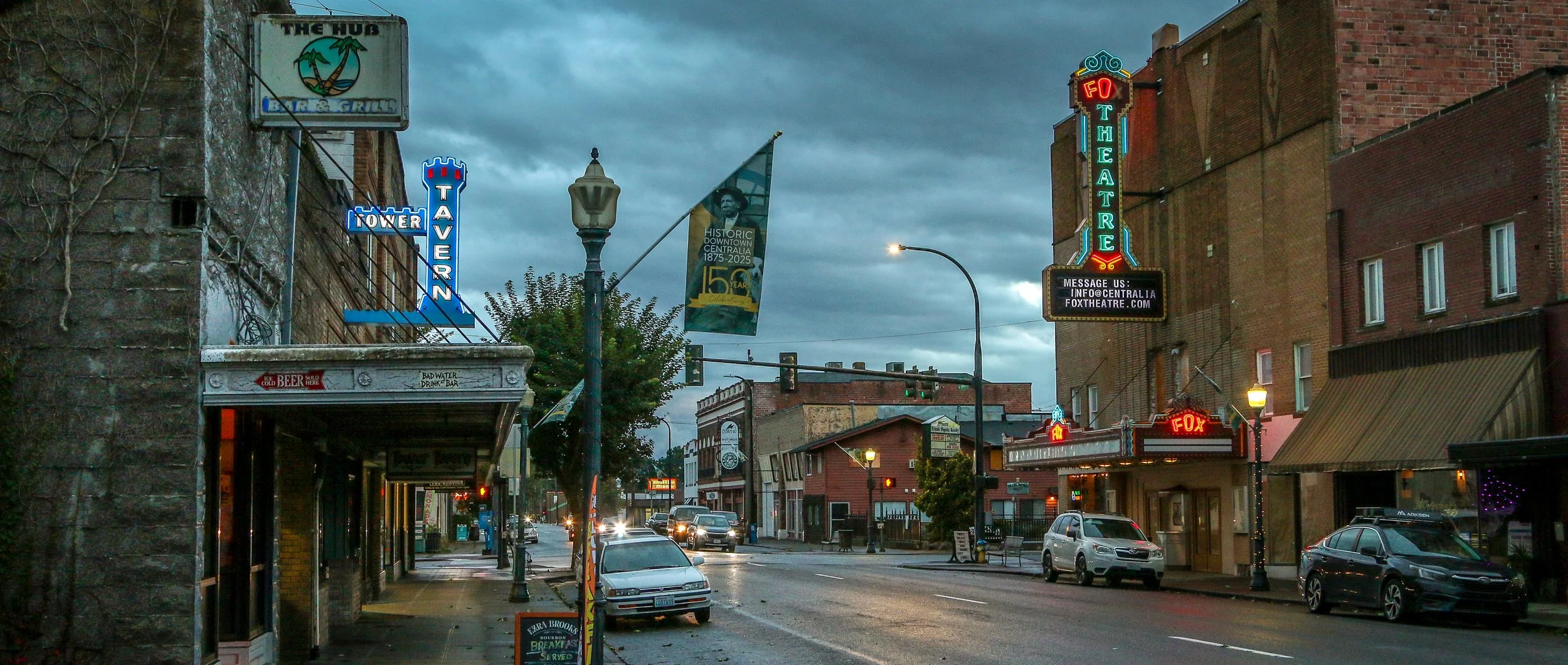
I came to Centralia to enjoy a night in the storied Olympic Club - a century old private men’s club turned hotel and bar. The beautiful, old mahogany bar, enormous woodstove, leaded glass fixtures and spacious pool room were all I imagined them to be and more and I definitely recommend a visit. But there was more to Centralia than the club. I found some great neon signs, a cool old theater, some colorful businesses, friendly locals and one of the prettiest tower clocks I’ve ever seen (so pretty I included day and nighttime photos below!).
This area was originally home to the Upper Chehalis people and settlers started arriving down the Oregon Trail in the mid 19th century. One of the original non-native settlers was a free Black man named George Washington who arrived in 1850 with his adoptive parents. Washington is remembered as the founder of Centralia and in 2023 his birthday was officially designated as Centralia’s Founder’s Day. When a road was built, it became the central stopping point on the stagecoach route between Tacoma and Kalama. When the Northern Pacific Railway came through in 1872, a town started to take shape and chose the name Centerville to denote its central location. A few years later, the townspeople worried they would be confused with another Washington town of the same name, so they changed their name to Centralia. It’s had its ups and downs since, but Centralia is still hanging on. Trains still come through town and it’s still a halfway stopping point, but now between Portland and Seattle. If you’re ever passing through on Interstate 5, stop through Centralia for a beer at the Olympic Club and stay for some classic Americana in Hub City. Enjoy these photos from beautiful Centralia, WA.
A Victorian waterfront town in a far-flung corner of America? You don’t have to tell me twice! Port Townsend is a magical place in the northeast corner of the Olympic Peninsula in the far north of Washington State. The bay on which the town sits was named “Port Townshend Bay” by George Vancouver way back in 1792. From the beginning it was recognized as a good, safe harbor and a town site was inevitable. Founded by Americans in 1851, it was the traditional homeland of no fewer than five American Indian bands. In the late 19th century, Port Townsend was called The City of Dreams and people imagined it would be the major port city to serve the Northwest United States. Grand buildings and homes were built in the Victorian style of the time and a magnificent county courthouse was erected to show the strength and stability of the town. Sadly an economic downturn caused the expected railroad links to stop far short of Port Townsend, choosing to end their cross country lines in Tacoma, Seattle and Tumwater instead. This was a huge blow to Port Townsend and one they would never really recover from. The construction of the U.S. Army base at Fort Worden around the turn of the century would keep the town afloat though and eventually people would recognize the beauty of Port Townsend. The town experienced a renewal of interest in the 1970s and many of the old buildings have been lovingly restored . Today it is a major tourism destination and has a busy ferry port as well. I really loved my stay in Port Townsend, especially exploring the downtown area and the fort (now a state park). I had a fantastic seafood feast at Sea J’s Café on the waterfront and the beers at Propolis Brewing were on a different level than most breweries. It’s a really cool town and one you should definitely put on your itinerary. Port Townsend is definitely the Crown Jewel of the Olympic Peninsula.
Construction on Fort Bowie began in 1862 after two separate confrontations between the United States Army and the Chiricahua Apache. The fort was erected to protect the Apache Pass through the mountains and Apache Springs, a vital water source in the area. Six years later a more substantial fort was built just up the hill from the original fort and would be in service until 1894. The Apache Wars would end in 1886 with the surrender of Chiricahua leader, Geronimo, and the removal of the Chiricahua from the area. As you may remember from a recent post, the U.S. Army was aided in this endeavor by the White Mountain Apache scouts based in Fort Apache to the north who were the sworn enemies of the Chiricahua.
The fort today is a mere remnant of what it once was. The adobe walls have all but melted back into the surrounding desert and the stone foundations and a few odds and ends are all that is left. This park is unique in that it is a “hike-in” park, meaning the only way to visit it is by hiking the 1.5 miles from the parking lot up to Apache Pass. This walk takes you past the old stagecoach stop ruins, the cemetery, an old Apache village, Apache Spring and up to the pass where the fort is located. While the rangers at the park will provide access for people with disabilities, this walk is an amazing way to get a feel for the remoteness of the fort and the isolation the men who were once stationed there must have felt. I was definitely glad I visited in the winter months as I’m sure making this walk in the summer is quite hot and dusty. I was definitely glad I finally made it out to Fort Bowie as it’s been on my to-do list for many years now and I’m glad I finally got there. I hope you enjoy these photos from Fort Bowie National Historic Park.
The area around what’s now Patagonia, Arizona was once a Tohono O’odham village called Sonoitac. It may take its current name from the southern region of South America, christened by Welsh miners who had moved north for work. Another theory is that early settlers found a large footprint, perhaps from a grizzly bear (or Sasquatch himself), and called it “Land of the Bigfeet”. However it got its name, Patagonia is a wonderful little town that’s big on art and seems to have sought to beautify even the smallest details of their town.
When the Spanish moved north into the area, they established the Mission Los Reyes de Sonoitac. The region became part of the United States through the Gadsden Purchase of 1853 and lead and silver mines were quickly opened. Fort Buchanan was established to provide protection for the settlers from Apache raiders, later to be joined by Forts Crittenden and Huachuca.
Fort Apache was constructed between 1874 and 1932 and served as an important military outpost during the Apache Wars. It rests in the midst of the beautiful White Mountains of Eastern Arizona. and is well situated at the convergence of the North and East Forks of the White River. The area is the ancestral home of the Cibicue and White Mountain Apache tribes who welcomed the United States Army to build the fort there, as they had a common enemy in the Chiricahua Apache. The White Mountain Apache are very proud of their service as scouts in the U.S. Army, and the role they played in the defeat of the Chiricahua and the capture of the great Chiricahuan leader, Geronimo. I learned a lot about the Apache Scouts and their campaigns at the wonderful "Nohwike' Bagowa" (House of Our Footprints), more commonly referred to as the Apache Cultural Center & Museum. which should be everyone’s first stop on any visit to Fort Apache.
After visiting the museum, I set off to explore the rest of the fort on a self guided walking tour which took in all of the wonderful historic buildings which remain on the post. After Geronimo’s capture in 1886, the fort remained an active military post for many years, finally closing in 1924 (although several Apache scouts remained in the army until 1947). After the army pulled out, the Theodore Roosevelt Indian Boarding School was established and the land was transferred to the Bureau of Indian Affairs as part of the White Mountain Apache Reservation. The school is still there and functioning today. I had a great visit with the kind and welcoming people of the White Mountain Apache band and really enjoyed my visit to this fascinating historic fort. I hope you enjoy these photos from Fort Apache.
There may be no more iconic plant in the United States than the stately and stoic saguaro cactus. These beautiful cacti can grow up to 40’ tall and live to be 150 years old. They won’t start growing arms until they are 75 years old and some will grow many arms in their lives. Most of the natural habitat of the saguaro is in the Sonoran Desert which straddles the U.S./Mexico border.
In 1933, President Herbert Hoover designated Saguaro National Monument which we now call the Rincon Mountain District of the park. In 1961, John F. Kennedy added the Tucson Mountain District to the Monument and in 1994 these two tracts were combined into Saguaro National Park.
I’ve spent a fair bit of time in Tombstone in my life. It was always a stop on my company’s cross-country winter trips, of which I ran many. But it was always a quick stop as we usually arrived late in the short winter day and left early the following morning, but my groups and I always enjoyed the old-west feel of the place, the dirt streets, the wooden sidewalks and having a few beers at Big Nose Kate’s Saloon. It was nice for me to get back this past winter after several years and have a little more time to spend there.
Tombstone is an old silver mining town, founded in 1877, and produced somewhere between $40 million and $85 million worth of silver bullion. During Tombstone’s heyday in the mid-1880s, the town boasted a population of 14,000 and was home to 110 saloons, two churches, three newspapers and a bowling alley. It was named the county seat of Cochise County, a designation it held until 1929. A fire in 1886 destroyed the mine’s central hoist and pumping plant and it was decided that with the productivity of the mines at that point, they weren’t worth rebuilding. The population would dwindle until tourists started to take an interest in the old west and come to have a look for themselves.
Tombstone is probably best known for the legendary shootout at the O.K. Corral between the Earp brothers and Doc Holiday and a group of cattle rustlers known as The Cowboys on October 26th, 1881.
Rio Grande del Norte is one of our more recent National Monuments, having been designated as such in 2013. It protects the confluence of the Red River and the Rio Grande which are both designated Wild and Scenic Rivers. Both gorges are gorgeous and the point of land above the confluence, called simply El Punto, provides amazing views from high above the two rivers. I hiked the Little Arsenic Trail while I was there, which brought me down to the Rio Grande and led me straight to the confluence. It was one of the better hikes I did during my stay in New Mexico and was very rewarding around every turn. I spent the night at the campground on the canyon rim and enjoyed a beautiful sunset in the evening and a magical sunrise the following morning. In between, the stars were spectacular. I debated whether to drive out to this park as it was somewhat out of the way, but I’m sure glad I did as it is stunning from end to end. If you’re ever in the area, you should as well. I hope you enjoy these photos from beautiful Rio Grande del Norte National Monument.
Nara Visa, New Mexico got its start as a rail town when the Chicago, Rock Island and Pacific Railroad was being built around the turn of the 20th century. It was originally called Narvaez after a local family who had farmed in the area for decades, but was eventually anglicized to some degree to Nara Visa. Within a decade, the town had grown to include 4 churches, 8 saloons, a couple of hotels and a whole array of small businesses. In 1921, with a growing population of 651, a fine school was built and the Works Progress Administration helped add a gymnasium a decade and a half later. The depression took its toll on the town though and lean years were ahead for Nara Visa. By 1968, there were only 7 students enrolled at the school when it closed its doors for the last time. Today less than a hundred people call the town home, and none of the businesses from this once thriving little community are open. It’s easy to pass through Nara Visa and not see it at all. I’m glad I got out and had a look. It makes me sad when towns die, but the reality is that everyone leaves at some point, one way or another. It looks like times were good there once, and maybe will be again at some point in the future. It sure made for some nice photos though. I hope you enjoy these photos from Nara Visa - a modern day ghost town in eastern New Mexico.
Construction of the pueblo at Pecos was begun sometime in the 12th century. Over the next few hundred years it would grow to become one of the largest pueblos in the area, supporting a community of perhaps 3,000 people. Sitting in what is now eastern New Mexico, this agricultural community was also a trade center between the mountains to the west and the plains to the east. Francisco Vázquez de Coronado visited Pecos on his 1540 conquest, as did Don Juan de Oñate 60 years later when he ordered construction of a mission church to help convert the Puebloans to Catholicism. That church was destroyed during the Pueblo Revolt of 1680 and a smaller church would be built in its place when the Spanish returned to the area twelve years later. The spread of European diseases would bring the ultimate demise of Pecos and in the 1830s the last of its old residents made their way to Jemez Pueblo where their culture and tradition is still remembered in the oral history. Emigrants on the nearby Santa Fe Trail no doubt used Pecos as a campground and marveled at the old pueblo. General Kearny and his troops camped at Pecos as well on their westward journey to claim New Mexico for the United States. During the Civil War, the Confederate army was making their way through New Mexico on a quest for Colorado and California gold. Their troops turned back to Texas after being defeated at the Battle of Glorieta Pass which is right up the trail from Pecos. Tex Austin purchased the land in 1925 and turned it into the Forked Lightning Ranch which was purchased in 1941 by Buddy Fogelson. The Fogelsons were instrumental in creating Pecos National Monument in 1965, and after their deaths the park’s boundaries were expanded to include the ranch and the designation changed to Pecos National Historical Park.
Today the park does an incredible job of interpreting all of this fascinating history in its wonderful museum. The 1.5 mile trail takes you through the remains of the pueblo and into the ruins of the old mission church. Two kivas have been reconstructed to provide some insight into Puebloan culture and religion as well. It’s a beautiful place to visit and just a short drive from nearby Santa Fe. I hope you enjoy these few photos from fascinating Pecos national Historical Park.
“The Original Las Vegas” was founded along the Galinas River in 1835 in the midst of Mexican rule in the area and quickly grew as a popular stop on the Santa Fe Trail. It was on the Plaza in Las Vegas where Stephen Watts Kearny claimed New Mexico for the United States during the Mexican-American War in 1846. In 1879, the Atchison, Topeka and Santa Fe Railroad came to Las Vegas and the town quickly grew into one of the largest in the region. The New Mexico Normal School (now Highlands University) was established in 1893 and Fred Harvey built the Castañeda Hotel in 1898 as part of his hospitality empire in the southwest. Las Vegas hosted Teddy Roosevelt’s Rough Riders’ first reunion in 1899, a tradition that continued for many years. In more recent years, Las Vegas has been the filming location for many movies including No Country For Old Men, Wyatt Earp (with Kevin Costner), and perhaps most notably for me, Red Dawn where it served as the fictional town of Calamut (the massive “Calamut Says Howdy” mural is still a prominent feature downtown). I found Las Vegas to be a quiet, charming University town with some spectacular architecture, fascinating history and friendly people. It may be the “other Las Vegas”, but it’s a town not to be missed on your travels in New Mexico. I hope you enjoy these photos from wonderful Las Vegas, New Mexico.
In 1598, Juan de Oñate y Salazar was on a conquest to colonize Nuevo Mexico for Spain. Traveling north of El Camino Real, his caravan had just passed through the dreaded 90 mile stretch known as the Journada del Muerto or “Journey of the Dead Man” when they encountered the Piro people of the Tempana Pueblo. These people offered the party food and water and Oñate called the place “Socorro” meaning succor or aid. In 1626, the Spanish built a mission church nearby and christened it Nuestra Señora del Perpetuo Socorro or Our Lady of Perpetual Succor. The mission was abandoned and destroyed during the Pueblo Revolt of 1680 and wouldn’t be resettled until 1815. A beautiful new church was built and named after San Miguel.
I came to Socorro because it was where I was when I ran out of steam for the day. It was on my radar, but I didn’t know if I would have time to stop. I’m sure glad I did. There are so many wonderful historic buildings around town, and the evening was absolutely perfect for photography. I enjoyed a nice long walk around downtown and then settled into the mining-era Capitol Bar for a couple of their house-brewed beers. Then I ventured out to El Camino Restaurant and Lounge, a holdover from another time. Both the restaurant and the lounge are worth visiting for the ambiance alone. It snowed overnight and while there wasn’t much on the ground, the mountains had a lovely dusting. I happily snapped a few more shots with the snow before hitting the road. Socorro is definitely worth a stop on your way through New Mexico and I hope you enjoy these photos from my brief time in this wonderful little town.