Gold was discovered in nearby Alder Creek in 1863, sparking off one of Montana’s biggest gold rushes. People came from far and wide to try and earn their fortune in what is now southwest Montana. Soon after the discovery, a mining district was established and was named Verina [sic] after Confederate President Jefferson Davis’ wife, Varina. In the midst of the Civil War, this couldn’t be allowed, so the name was changed to Virginia City. When Montana Territory was carved from the existing Idaho Territory in 1864, Bannack was chosen as the capital, but the capital was moved to Virginia City just a year later. Virginia City would remain the capital for a decade before it was moved again to Helena. In the early days, a road gang called The Innocents was preying on wagons moving between the mining towns. In response, Virginia City residents formed The Montana Vigilantes who rode on The Innocents and lynched them in the streets of nearby Bannack. Virginia City is considerably quieter these days. With some lovely shops, some good restaurants and a couple of bars, including Montana’s oldest the Bale of Hay Saloon, Virginia City is a wonderful place for a wander. I hope you enjoy these photos from the cool, historic town of Virginia City, Montana’s second territorial capital.
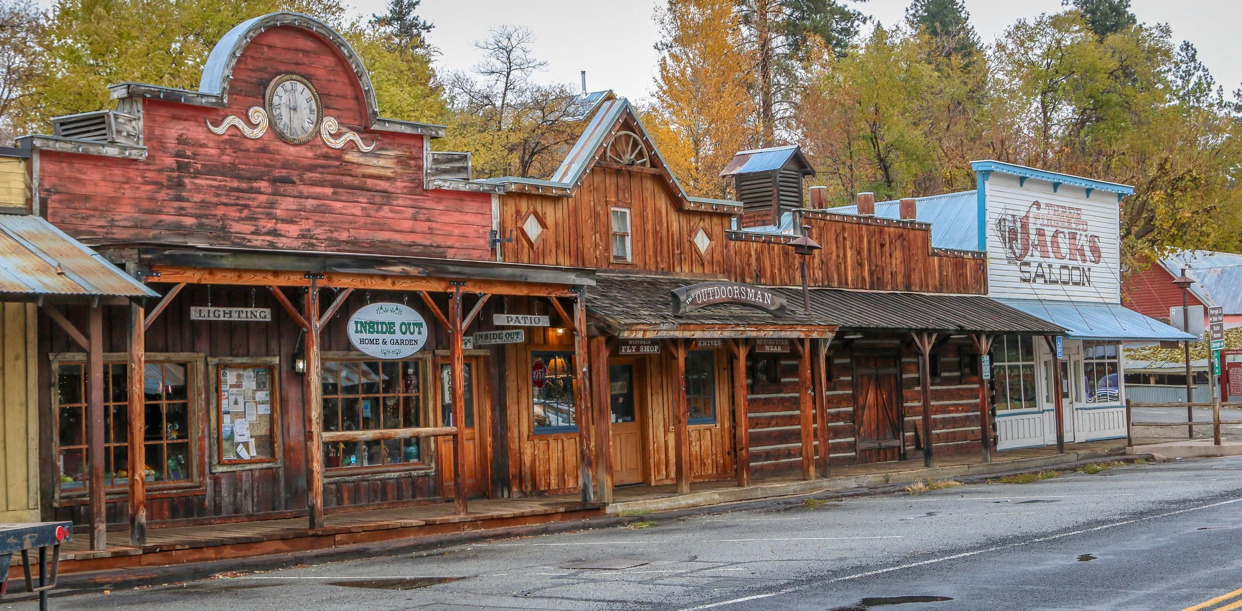
Winthrop is a great little Old West themed town on the east side of the North Cascade Mountains. The area was originally inhabited by the Methow People who made seasonal hunting and fishing camps along the Methow and Chewuch Rivers. In 1891, a man named Guy Waring, who had been a Harvard classmate of Theodore Roosevelt, made a homesteading claim at the confluence of the two rivers and established a trading post. As a town grew up around Waring’s store, they chose the name Winthrop after Major Theodore Woolsey Winthrop who had traveled extensively in Washington (and elsewhere) and was one of the first Union officers killed in the Civil War. Guy Waring irrigated the town, built a sawmill, started a cattle ranch and an apple farm and ran the Duck Brand Saloon in town (now Town Hall) before returning to the east in 1917. Winthrop carried on without him. The town was an early adapter to tourism with several dude ranches opening in the 1930s. When the road through the North Cascades was finally ready to open in 1972, the people of Winthrop adopted a plan to beautify the downtown area with an Old West theme. The result is a fun town that you have to simply have to stop and wander through. I had been to Winthrop before, several years ago, and was looking forward to checking it out again on this trip through. I love the architecture in Winthrop, especially the glistening white Farmers State Bank and the Old Schoolhouse Brewery. The Shafer Museum is also excellent and is mostly outdoors so it is accessible even outside of their business hours. I really enjoyed my stay in Winthrop and the cloudy skies helped portray how chilly it was there in late fall. I hope you enjoy these photos from beautiful downtown Winthrop, Washington’s Old West town.
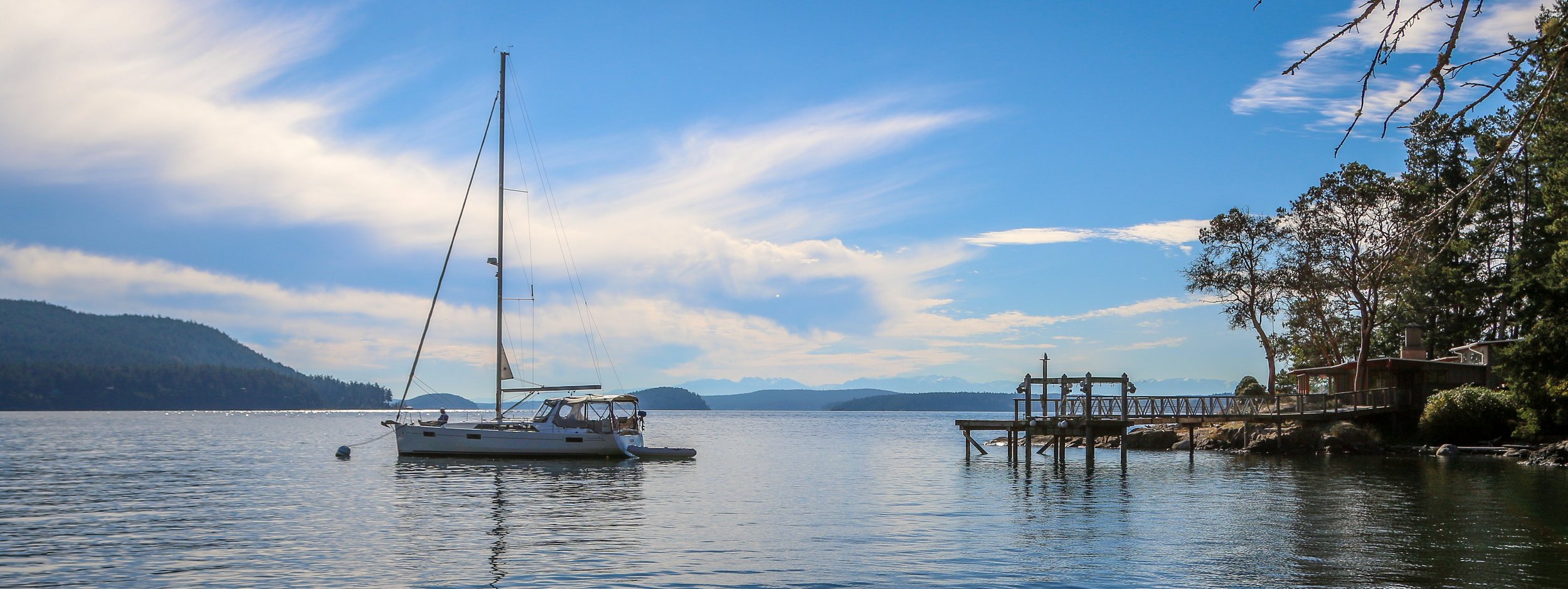
The San Juan Islands are a beautiful archipelago located off the coast of Washington State in the far northwest of the country. Originally home to different bands of the Coast Salish people, the islands were named by Spanish explorer Francisco de Eliza in 1791. After the Oregon Treaty of 1846 established the border between the United States and British Canada at the 49th Parallel, ownership of the San Juans came under dispute. Forts were established on both sides of San Juan Island and when an American soldier shot a British pig, the 12 year Pig War began. This was a bloodless war (except for the pig), and soldiers from both sides were frequently found socializing in the opposing fort. Athletic competitions were held between the two. Finally, in 1871, Emperor Wilhelm I of Germany stepped in and proclaimed that the Haro Straight would be the border between the countries, leaving Vancouver Island in British hands and the San Juans with America. I enjoyed my visit to three of the San Juan Islands on this trip - San Jan Island itself, Orcas Islands and tiny Lopez Island. I hope you enjoy these photos from the beautiful San Juan Islands of Washington.
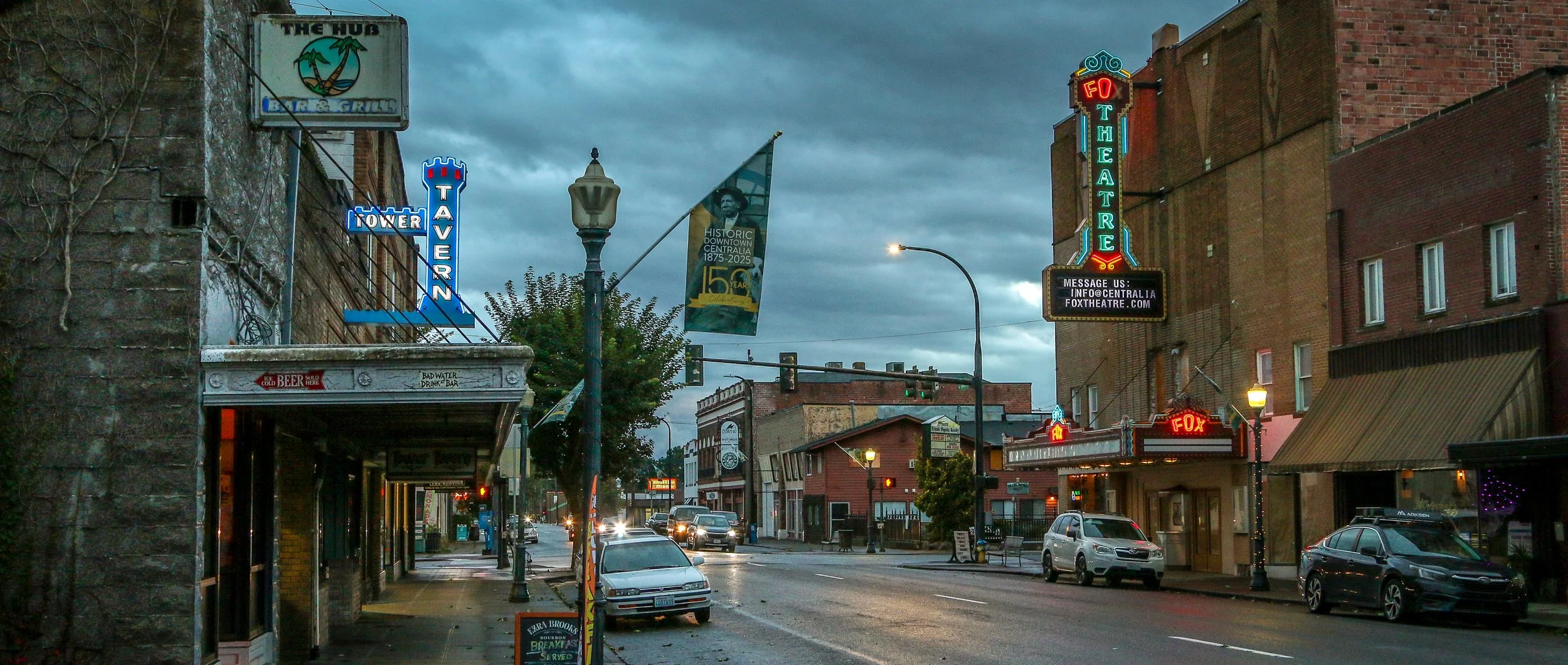
I came to Centralia to enjoy a night in the storied Olympic Club - a century old private men’s club turned hotel and bar. The beautiful, old mahogany bar, enormous woodstove, leaded glass fixtures and spacious pool room were all I imagined them to be and more and I definitely recommend a visit. But there was more to Centralia than the club. I found some great neon signs, a cool old theater, some colorful businesses, friendly locals and one of the prettiest tower clocks I’ve ever seen (so pretty I included day and nighttime photos below!).
This area was originally home to the Upper Chehalis people and settlers started arriving down the Oregon Trail in the mid 19th century. One of the original non-native settlers was a free Black man named George Washington who arrived in 1850 with his adoptive parents. Washington is remembered as the founder of Centralia and in 2023 his birthday was officially designated as Centralia’s Founder’s Day. When a road was built, it became the central stopping point on the stagecoach route between Tacoma and Kalama. When the Northern Pacific Railway came through in 1872, a town started to take shape and chose the name Centerville to denote its central location. A few years later, the townspeople worried they would be confused with another Washington town of the same name, so they changed their name to Centralia. It’s had its ups and downs since, but Centralia is still hanging on. Trains still come through town and it’s still a halfway stopping point, but now between Portland and Seattle. If you’re ever passing through on Interstate 5, stop through Centralia for a beer at the Olympic Club and stay for some classic Americana in Hub City. Enjoy these photos from beautiful Centralia, WA.
A Victorian waterfront town in a far-flung corner of America? You don’t have to tell me twice! Port Townsend is a magical place in the northeast corner of the Olympic Peninsula in the far north of Washington State. The bay on which the town sits was named “Port Townshend Bay” by George Vancouver way back in 1792. From the beginning it was recognized as a good, safe harbor and a town site was inevitable. Founded by Americans in 1851, it was the traditional homeland of no fewer than five American Indian bands. In the late 19th century, Port Townsend was called The City of Dreams and people imagined it would be the major port city to serve the Northwest United States. Grand buildings and homes were built in the Victorian style of the time and a magnificent county courthouse was erected to show the strength and stability of the town. Sadly an economic downturn caused the expected railroad links to stop far short of Port Townsend, choosing to end their cross country lines in Tacoma, Seattle and Tumwater instead. This was a huge blow to Port Townsend and one they would never really recover from. The construction of the U.S. Army base at Fort Worden around the turn of the century would keep the town afloat though and eventually people would recognize the beauty of Port Townsend. The town experienced a renewal of interest in the 1970s and many of the old buildings have been lovingly restored . Today it is a major tourism destination and has a busy ferry port as well. I really loved my stay in Port Townsend, especially exploring the downtown area and the fort (now a state park). I had a fantastic seafood feast at Sea J’s Café on the waterfront and the beers at Propolis Brewing were on a different level than most breweries. It’s a really cool town and one you should definitely put on your itinerary. Port Townsend is definitely the Crown Jewel of the Olympic Peninsula.
Originally a Pomo Indian settlement, a lumber town was established on this site in 1852. The town was originally called Meiggsville, and then Big River before finally settling on Mendocino, named after Spanish navigator Antonio de Mendoza. Many of Mendocino’s early non-native settlers were from New England which is definitely evident in the architecture. In fact, several episodes of the TV show Murder, She Wrote were filmed here, and Mendocino stood in for the fictional town of Cabot Cove, Maine. Quite a few films were made here as well, perhaps the most memorable of which was James Dean’s 1955 classic East of Eden. Today, Mendocino is one of the most charming little towns along the California coast and attracts a wonderful mix of artists, tourists and small-town enthusiasts like myself. I thought it was cool that the town still has many of the original wooden water towers, built before the town had a central water supply. My favorite places to photograph were definitely the stunning old Masonic Hall with it’s beautiful statue called Time and the Maiden, the old Mendocino Beacon Building, the unique water towers and of course the gorgeous coastline. I hope you enjoy these photos from stunning Mendocino, California.
I absolutely love Joshua Trees. Much like the Saguaros are iconic to the Sonoran Desert, the Joshua Trees are iconic symbols of the Mojave Desert and it’s too easy to imagine human characteristics in both. Every time I pull into an area with Joshua Trees it makes me smile and feel happy. Interestingly, Joshua Trees aren’t really trees at all, but rather a tree-like member of the yucca family. They may have been given their name by early Mormon pioneers who thought they resembled the Biblical Joshua with his arms raised.
It is believed that people have been living in the region of Joshua Tree National Park for 10,000 years. The first people of European descent who laid eyes on the area were with Spaniard Pedro Fages who was pursuing Native Americans who had “escaped” the mission in San Diego. After the Mexican-American War, American settlers started moving in, building ranches and doing some small-scale mining. Franklin Roosevelt protected the area as Joshua Tree National Monument in 1936 and it became a National Park in 1994. The park covers 1,242 square miles - slightly larger than the state of Rhode Island.
I’ve visited Joshua Tree National Park several times before, but always in the middle of summer when it was boiling hot out. We might get out and take some photos, but long hikes were pretty much out of the question. I was really happy to get there this past spring when it was cool and pleasant and I could get out on the trails. I hiked the Short Loop Trail from Black Rock Campground, Ryan Mountain, and the Lost Horse Mine Loop among others and they were all fantastic. Joshua Tree National Park is a special place and while it doesn’t get the hype of our other western National Parks, it’s definitely worth a visit. I can’t wait to return. I hope you enjoy these photos from beautiful Joshua Tree National Park.
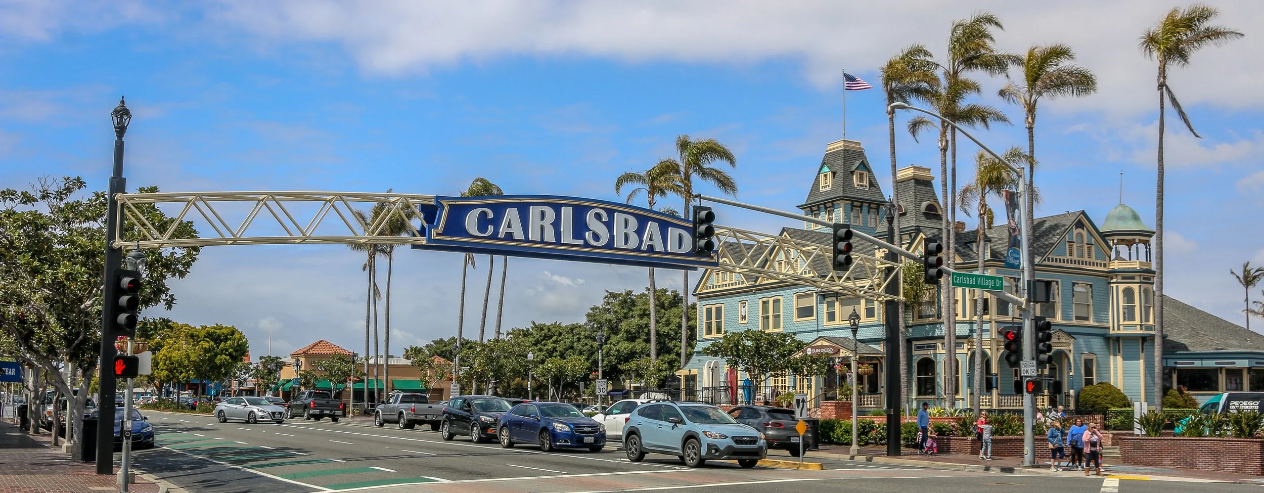
Located right on Highway 101 between Los Angeles and San Diego is the gorgeous little city of Carlsbad. As you drive down the highway, you can’t help but notice the beautiful Twin Inn on the inland side of the road. It’s the kind of building that just sparks your interest, especially a block from the beach in Southern California. The Inn was built by Civil War veteran Gerhard Schutte in 1887. Schutte and his partners laid out the townsite of Carlsbad as “a town of small farms and gracious homes”. They sold plots at $40/acre and the town grew from there.
This area was originally inhabited by the Payómkawichum and Kumeyaay people who enjoyed the bounty of the sea and the fresh water provided by Buena Vista Creek. When the Portola Expedition came to California in 1769 they camped on Buena Vista Creek and mingled and traded with the native people. During the Mexican period, the area that is now Carlsbad was part of Rancho Agua Hedionda which wasowned by Juan María Marrón.
In the early 1880s, a man named John Frazier dug a well and served up water to thirsty train passengers on their way through. It turned out that the water was quite special and the area became known as Karlsbad after a famous Bohemian spa town. Enter Gerhard Shutte and his Carlsbad Land and Mineral Water Company which laid out and promoted the town as mentioned above.
Today, Carlsbad is a pleasant, medium sized city of about 114,000 people. I really enjoyed walking around on a beautiful, sunny spring day to take these photos. The old train station has been converted into the town’s visitor center and the Twin Inn has been incorporated into the Village Faire shopping area. I also loved the many old and quirky buildings I found as I made my way around the city center and the modern parts of Carlsbad have been tastefully added to enhance the city’s beauty. There are plenty of beautiful murals around and some great shops and restaurants as well. I’m so glad I stopped in to see Southern California’s stunning Village by the Sea. I will definitely be back to visit again in the future. I hope you enjoy these photos of beautiful Carlsbad, California.
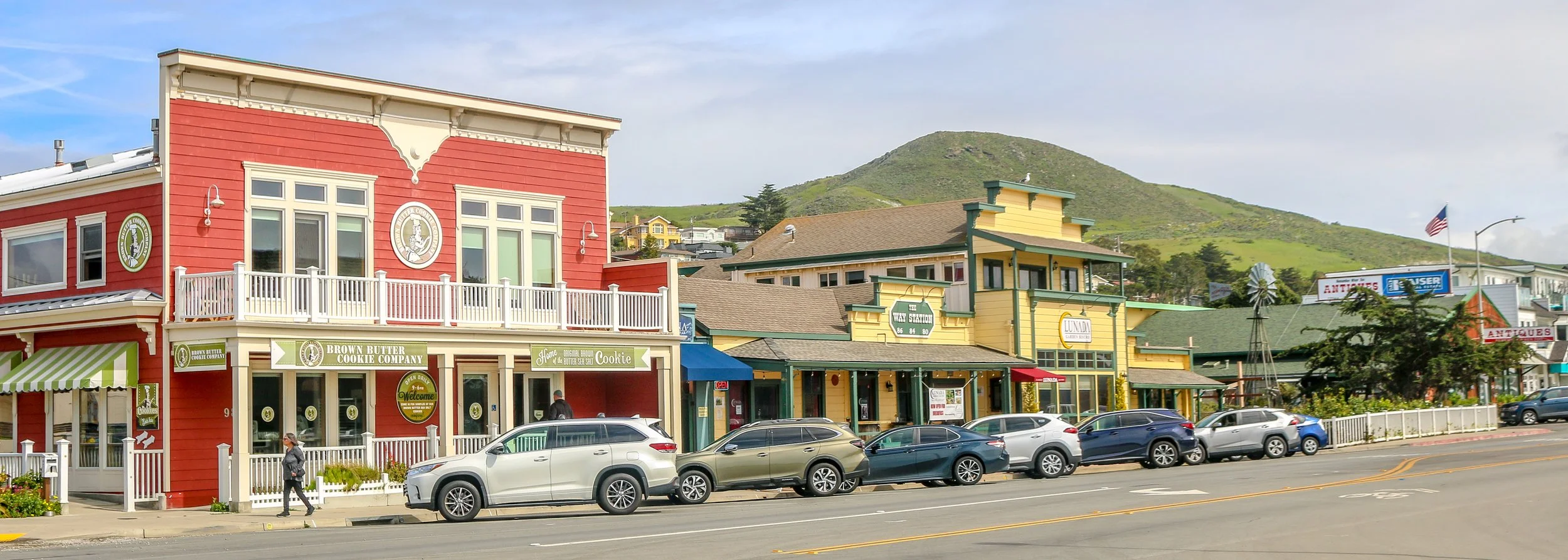
Cayucos is a pleasant beach community located on the Estero Bay along the Central California Coast. Originally inhabited by the Chumash people, the area was explored by the Portola Expedition in 1769. The Spanish explorers noted the Chumash out fishing in small canoes and named the area Cayucos - the Spanish name for a small boat. The town was established in 1867 by Captain James Cass who built the original pier and a warehouse to store goods and make Cayucos a port town. Today Cayucos is home to around 2500 people and is a great town to stop in on your journey up or down the coast.
I stumbled into Cayucos by accident as I made my way down the Pacific Coast Highway. I stopped near the pier to use the bathroom and was impressed by the Dale Evers’ statue called The Great Communicators at the head of the pier (pictured below). I decided to stroll down the pier and enjoyed watching the surfers catch some waves. As I walked back towards my van, I saw a cool old convertible make the turn in front of me and looked down the street to see the Brown Butter Baking Company. Of course I had to stop for a cookie for research purposes, and I started to see all kinds of cool buildings to photograph. I ended up staying in Cayucos for a few hours and really enjoyed the town. It had all the amenities of any beach town along the coast, but was wonderfully clean, quiet and friendly. It’s a town I will definitely be back to and I see where they get their nickname: A Little Slice of Paradise. I hope you enjoy these photos from beautiful Cayucos, California.
The area that is now Wickenburg was once Yavapai Indian land and the river that runs through it is the Hassayampa which means “following the water as far as it goes” in the Yavapai language. In 1863, German prospector Henry Wickenburg came to the area in search of gold. He found it and opened the Vulture Mine which would eventually produce 340,000 ounces of gold and 260,000 ounces of silver.
Ranchers came to the area as well and soon a community sprang up. In 1895, the railroad came through Wickenburg which spawned even more growth. The town was incorporated in 1909, making Wickenburg the oldest Arizona town north of Tucson and the 5th oldest in the state. In 1866, Wickenburg missed being named the territorial capital by just two votes.
Today Wickenburg is a quaint little community with a real wild west feel to it (some of the light posts are even wearing cowboy hats). There are some amazing art installations around town and the Desert Caballeros Western Museum is one of the best in the state. I love the design of the Saguaro Theatre which was also probably my favorite theatre in Arizona. You’re never alone when you’re in Wickenburg as life-like statues are spread throughout town making for a family friendly feel. I hadn’t planned on staying long in Wickenburg, but it’s a great town worth exploring and I was there way longer than I expected to be. Next time you’re in this part of Arizona, stop in for a spell. You’ll be glad you did. I hope you enjoy these photos from tiny Wickenburg - the Dude Ranch Capital of the World.
Organ Pipe Cactus National Monument was one of the top spots on my list of places to visit during my time in Arizona. It’s a remote park, located two hours from anywhere and right on the U.S./Mexican border, but it’s the only place in the country that you can find naturally occurring organ pipe cactus. In addition to these beauties, there are so many other species of cactus and desert plants as well which has led to this region also being named a part of UNESCO’s International Biosphere Reserve.
Organ Pipe Cactus was made a National Monument by Franklin Roosevelt back in 1937. A special act was passed to allow mining in the area during World War II, an act which sadly wasn’t repealed until 1976. The park’s remote location on the Mexican border used to bring both drug runners and human smugglers through the area, making this America’s most dangerous park. This danger is memorialized in the Kris Eggle Visitors Center which was named for a park ranger who was killed protecting visitors from drug smugglers in 2002. In the wake of his death, the border was reinforced and I felt safe there during my stay.
It was unbelievably hot when I arrived on an afternoon in late April. So hot that I couldn’t actually do anything but hover in the shade of the restroom and wait until the sun started to go down. I did enjoy a wonderful evening hike and an early morning one the following day as well. The area is beautiful and it was great to see the Organ Pipes in their native habitat. It was definitely just a one night stop, but I’m very glad I went. I hope you enjoy these photos from Organ Pipe Cactus National Monument.
Construction on Fort Bowie began in 1862 after two separate confrontations between the United States Army and the Chiricahua Apache. The fort was erected to protect the Apache Pass through the mountains and Apache Springs, a vital water source in the area. Six years later a more substantial fort was built just up the hill from the original fort and would be in service until 1894. The Apache Wars would end in 1886 with the surrender of Chiricahua leader, Geronimo, and the removal of the Chiricahua from the area. As you may remember from a recent post, the U.S. Army was aided in this endeavor by the White Mountain Apache scouts based in Fort Apache to the north who were the sworn enemies of the Chiricahua.
The fort today is a mere remnant of what it once was. The adobe walls have all but melted back into the surrounding desert and the stone foundations and a few odds and ends are all that is left. This park is unique in that it is a “hike-in” park, meaning the only way to visit it is by hiking the 1.5 miles from the parking lot up to Apache Pass. This walk takes you past the old stagecoach stop ruins, the cemetery, an old Apache village, Apache Spring and up to the pass where the fort is located. While the rangers at the park will provide access for people with disabilities, this walk is an amazing way to get a feel for the remoteness of the fort and the isolation the men who were once stationed there must have felt. I was definitely glad I visited in the winter months as I’m sure making this walk in the summer is quite hot and dusty. I was definitely glad I finally made it out to Fort Bowie as it’s been on my to-do list for many years now and I’m glad I finally got there. I hope you enjoy these photos from Fort Bowie National Historic Park.