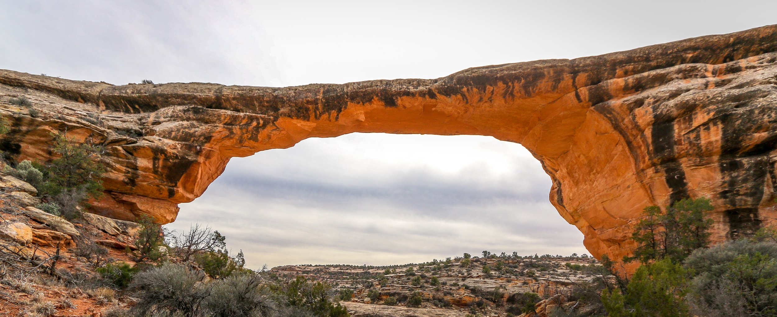
Natural Bridges National Monument became Utah’s first National Monument in 1908. It protects three impressive natural bridges situated in White and Armstrong Canyons in the southeast part of the state. A natural bridge is geologically different from an arch in that a bridge is formed by running water whereas an arch is not. Utah has quite a few of both.
The human history of this area stretches back at least 9,000 years as archaeologists have found tools and other evidence dating to that time. Ruins in the park show that the Ancestral Puebloans inhabited the area from around 700AD to around 1270AD. In more recent times, Paiute and Navajo people have made their homes in and around these canyons. in 1883, a man named Chris Hite wandered up White Canyon in search of gold and brought word of these magnificent natural bridges to the outside world. National Geographic did a story on the bridges in 1904 and in 1908 Theodore Roosevelt designated them a part of a new National Monument. Very few visitors came in the early years of the park as it was a three day horseback ride from the nearest town. A uranium boom in the 1950s brought roads to the area and those roads were paved in 1976, allowing easier access to see the bridges.
Natural Bridges National Monument is a beautiful place. It’s quiet and remote and definitely off the beaten path. Unfortunately, I imagine most people visit on their way between one place and the next and only stop at the overlooks to get a look at the bridges. To really appreciate them, you need to hike down into the canyon and get a closer look. The trail to Sipapu Bridge is an adventure in its own right, descending several ladders on the way to the canyon floor. Getting down to Kachina and Owachomo Bridges is easier, and I even enjoyed hiking between these two along the canyon bottom. Like most of the Desert Southwest, the natural bridges are at their best at the edges of the day when the sun is low and the sandstone lights up. I hope you enjoy these photos from beautiful Natural Bridges National Monument, well worth the detour if you’re ever in the area.
I absolutely love Joshua Trees. Much like the Saguaros are iconic to the Sonoran Desert, the Joshua Trees are iconic symbols of the Mojave Desert and it’s too easy to imagine human characteristics in both. Every time I pull into an area with Joshua Trees it makes me smile and feel happy. Interestingly, Joshua Trees aren’t really trees at all, but rather a tree-like member of the yucca family. They may have been given their name by early Mormon pioneers who thought they resembled the Biblical Joshua with his arms raised.
It is believed that people have been living in the region of Joshua Tree National Park for 10,000 years. The first people of European descent who laid eyes on the area were with Spaniard Pedro Fages who was pursuing Native Americans who had “escaped” the mission in San Diego. After the Mexican-American War, American settlers started moving in, building ranches and doing some small-scale mining. Franklin Roosevelt protected the area as Joshua Tree National Monument in 1936 and it became a National Park in 1994. The park covers 1,242 square miles - slightly larger than the state of Rhode Island.
I’ve visited Joshua Tree National Park several times before, but always in the middle of summer when it was boiling hot out. We might get out and take some photos, but long hikes were pretty much out of the question. I was really happy to get there this past spring when it was cool and pleasant and I could get out on the trails. I hiked the Short Loop Trail from Black Rock Campground, Ryan Mountain, and the Lost Horse Mine Loop among others and they were all fantastic. Joshua Tree National Park is a special place and while it doesn’t get the hype of our other western National Parks, it’s definitely worth a visit. I can’t wait to return. I hope you enjoy these photos from beautiful Joshua Tree National Park.
Organ Pipe Cactus National Monument was one of the top spots on my list of places to visit during my time in Arizona. It’s a remote park, located two hours from anywhere and right on the U.S./Mexican border, but it’s the only place in the country that you can find naturally occurring organ pipe cactus. In addition to these beauties, there are so many other species of cactus and desert plants as well which has led to this region also being named a part of UNESCO’s International Biosphere Reserve.
Organ Pipe Cactus was made a National Monument by Franklin Roosevelt back in 1937. A special act was passed to allow mining in the area during World War II, an act which sadly wasn’t repealed until 1976. The park’s remote location on the Mexican border used to bring both drug runners and human smugglers through the area, making this America’s most dangerous park. This danger is memorialized in the Kris Eggle Visitors Center which was named for a park ranger who was killed protecting visitors from drug smugglers in 2002. In the wake of his death, the border was reinforced and I felt safe there during my stay.
It was unbelievably hot when I arrived on an afternoon in late April. So hot that I couldn’t actually do anything but hover in the shade of the restroom and wait until the sun started to go down. I did enjoy a wonderful evening hike and an early morning one the following day as well. The area is beautiful and it was great to see the Organ Pipes in their native habitat. It was definitely just a one night stop, but I’m very glad I went. I hope you enjoy these photos from Organ Pipe Cactus National Monument.
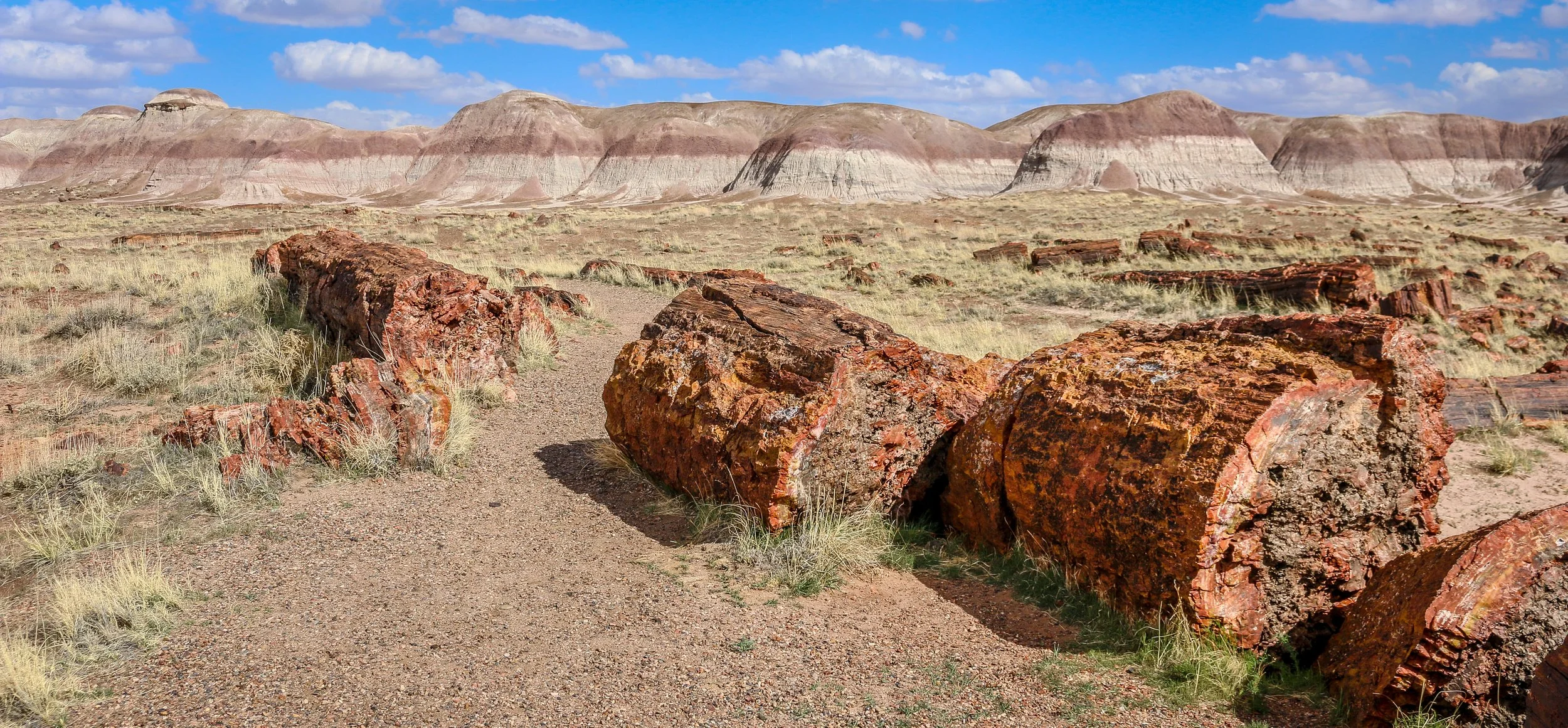
Petrified Forest National Park in eastern Arizona contains a beautiful collection of petrified wood and also includes the Painted Desert, Blue Mounds and an old stretch of Route 66. It’s a park best explored by car, but you won’t really appreciate it unless you get out and hike out into the wilderness. Petrified Forest was designated a National Monument back in 1906 and was upgraded to a National Park in 1962. I enjoyed my visit to the park and hope you enjoy these photos I took exploring the Petrified Forest.
After the Treaty of Guadalupe Hidalgo ended the Mexican-American War in 1848, New Mexico officially became a part of the United States. Americans started moving west to try and stake a claim in this new territory, but were often met with hostility by Indians trying to protect what they believed belonged to them. In response, the U.S. government built Fort Union at the main junction on the Santa Fe Trail. The original fort was good enough for that purpose, but a second, stronger, fort was built during the Civil War and a third fort soon replaced the second. The fort served two main purposes which were independent of each another - one being a military post and the other, a quartermaster depot. The depot was the supply hub for the government in the southwest and received hundreds of wagonloads of supplies daily to support 46 regional posts. There was also an arsenal on the base which could have also been seen as a separate entity as it had its own commander and staff. In addition, the base hospital provided the best medical care for hundreds of miles around. Fort Union served as the jumping-off point for Union forces on their way to fight at Glorieta Pass, the last Civil War battle fought in New Mexico. After the Civil War, African-American soldiers with the 57th U.S. Colored Infantry arrived at Fort Union and later the 9th U.S. Cavalry, remembered today as the Buffalo Soldiers, would join them. When trains started rumbling across the country at the end of the 19th century, Fort Union became obsolete and was decommissioned in 1891. The last soldiers left on May 15th of that year. In 1954, it became Fort Union National Monument and its history is now interpreted by the National Park Service.
Most of the fort was built of adobe which, without regular maintenance, will melt back into the desert. Some exceptions were the stone jail and the brick chimneys which provide a glimpse into what Fort Union once was. This park site doesn’t get many visitors, but it’s a fascinating place to learn about the Santa Fe Trail and early American history in the New Mexico Territory. I hope you enjoy these photos from fascinating Fort Union National Monument.
Construction of the pueblo at Pecos was begun sometime in the 12th century. Over the next few hundred years it would grow to become one of the largest pueblos in the area, supporting a community of perhaps 3,000 people. Sitting in what is now eastern New Mexico, this agricultural community was also a trade center between the mountains to the west and the plains to the east. Francisco Vázquez de Coronado visited Pecos on his 1540 conquest, as did Don Juan de Oñate 60 years later when he ordered construction of a mission church to help convert the Puebloans to Catholicism. That church was destroyed during the Pueblo Revolt of 1680 and a smaller church would be built in its place when the Spanish returned to the area twelve years later. The spread of European diseases would bring the ultimate demise of Pecos and in the 1830s the last of its old residents made their way to Jemez Pueblo where their culture and tradition is still remembered in the oral history. Emigrants on the nearby Santa Fe Trail no doubt used Pecos as a campground and marveled at the old pueblo. General Kearny and his troops camped at Pecos as well on their westward journey to claim New Mexico for the United States. During the Civil War, the Confederate army was making their way through New Mexico on a quest for Colorado and California gold. Their troops turned back to Texas after being defeated at the Battle of Glorieta Pass which is right up the trail from Pecos. Tex Austin purchased the land in 1925 and turned it into the Forked Lightning Ranch which was purchased in 1941 by Buddy Fogelson. The Fogelsons were instrumental in creating Pecos National Monument in 1965, and after their deaths the park’s boundaries were expanded to include the ranch and the designation changed to Pecos National Historical Park.
Today the park does an incredible job of interpreting all of this fascinating history in its wonderful museum. The 1.5 mile trail takes you through the remains of the pueblo and into the ruins of the old mission church. Two kivas have been reconstructed to provide some insight into Puebloan culture and religion as well. It’s a beautiful place to visit and just a short drive from nearby Santa Fe. I hope you enjoy these few photos from fascinating Pecos national Historical Park.
Magnificent White Sands National Park in central New Mexico preserves the largest gypsum dune field of its kind in the world. This dune field in the heart of the Tularosa Basin covers 145,762 acres and includes 4.5 billion tons of gypsum sand. This gypsum was left in the area after the Permean Sea retreated several million years ago, and water and wind shape the dunes we find there today. The dunes are ever changing, though, so you will never see the same landscapes on any two visits to the park.
People have been coming through the area for at least 11,000 years and we believe that a group we call the Jornada Mogollon were the first to farm the area (see my photos of their nearby petroglyph site here). Groups of Apache made their way into the area in the 1600s and European-Americans arrived in the 1800s. White Sands National Monument was created by Herbert Hoover in 1933 and it was made a National Park in 2019.
I arrived for my visit to the park just after dawn. The mountains to the east block the sunrise, but the skies were blue and full of amazing white clouds. I headed straight out to the heart of the dunes and hiked the wonderful 5 mile Alkali Flats Trail. The sun reflected brightly off the white sand making photography difficult, but I was grateful that there was no wind. In the late afternoon I set out to capture some of the beautiful plant life in the park, mainly different kinds of yucca, which contrast nicely with the white sand. I stayed to watch the sunset and found real peace and solitude out in the middle of the park. It was a wonderful day in White Sands National Park. You can find some of these photos for sale in my store , but please contact me if the one you want isn’t there and I’ll be happy to add it. I hope you enjoy these photos from my time in White Sands National Park.
Apostle Islands National Lakeshore is a beautiful park which stretches along Wisconsin’s Lake Superior coastline. The park extends over 21 of the 22 islands in the area with only Madeline Island being outside its boundary. In addition to the islands themselves, the park extends to the historic fishing area at Little Sand Bay and the beautiful coastline and sea caves at Myers Beach. Nobody is quite sure who gave the islands their names, but French maps referred to them as the Apostle Islands as early as the 1700s. The National Lakeshore was established in 1970, having been proposed by Wisconsin’s Senator Gaylord Nelson who is also considered the founder of Earth Day.
During my time in the park, I enjoyed a scenic cruise around the islands with Apostle Island Cruises. Our 2.5 hour journey took us around most of the islands with special attention paid to the beautiful, outer Devil’s Island and the historic lighthouse at Raspberry Island. Unfortunately, the islands were closed to camping during my stay so I wasn’t able to spend the night out there which I really would have enjoyed. Beyond the cruise, I spent some time learning about the history of the area at the outdoor museum at Little Sand Bay (which was also a wonderful place to watch the sunset). There were also recorded stories from rangers, historians and Native Americans in this section to listen to. On my last morning in the park I visited the Myers Beach section to hike the Lakeshore Trail to The Bowl to view the amazing sea caves and beautiful coastline. I was also pleasantly surprised by the number and variety of mushrooms I experienced along this trail. I had a wonderful visit to the Apostle Islands and hope you enjoy these photos from my stay.
The Ojibwa Indians called Isle Royale “Minong” meaning “a good place to be” and they certainly hit the nail on the head with that one. Isle Royale National Park consists of Isle Royale itself and over 400 smaller islands making up an archipelago in the middle of Lake Superior. Isle Royale is the largest natural island on Lake Superior and the second largest in the Great Lakes at 45 miles long and 9 miles wide. Some of Michigan’s earliest copper mines were established on Isle Royale in the 1840s, continuing the Ojibwa copper-mining tradition which stretched back hundreds of years. Commercial fishing operations also ran off of Isle Royale for many years, but it was the island’s beauty and ability to attract tourism which would create its lasting industry. Isle Royale National Park was established in 1940 and it was made a part of the UNESCO International Biosphere Reserve in 1980.
I had a wonderful 4 day/3 night visit to Isle Royale in the beginning of August. The island is only accessible by boat or plane, with ferries originating out of Houghton and Copper Harbor in Michigan and Grand Portage in Minnesota. I chose the Isle Royale Queen IV out of Copper Harbor which dropped me off in Rock Harbor on the island’s northeast side in about three and a half hours. After getting my backcountry permit from the ranger there, I headed off into the wilderness for the next three nights, staying at Daisy Farm, Lynn Cove and Three Mile campgrounds. I hiked about 25 miles during my time on Isle Royale and really found the island to be a beautiful place to be. After hiking all day, an afternoon dip in Lake Superior always felt great. I saw 9 moose during my visit and also a handful of beavers along with plenty of birds and toads. I really cherished my time on Isle Royale and hope you enjoy these photos from America’s least visited National Park.
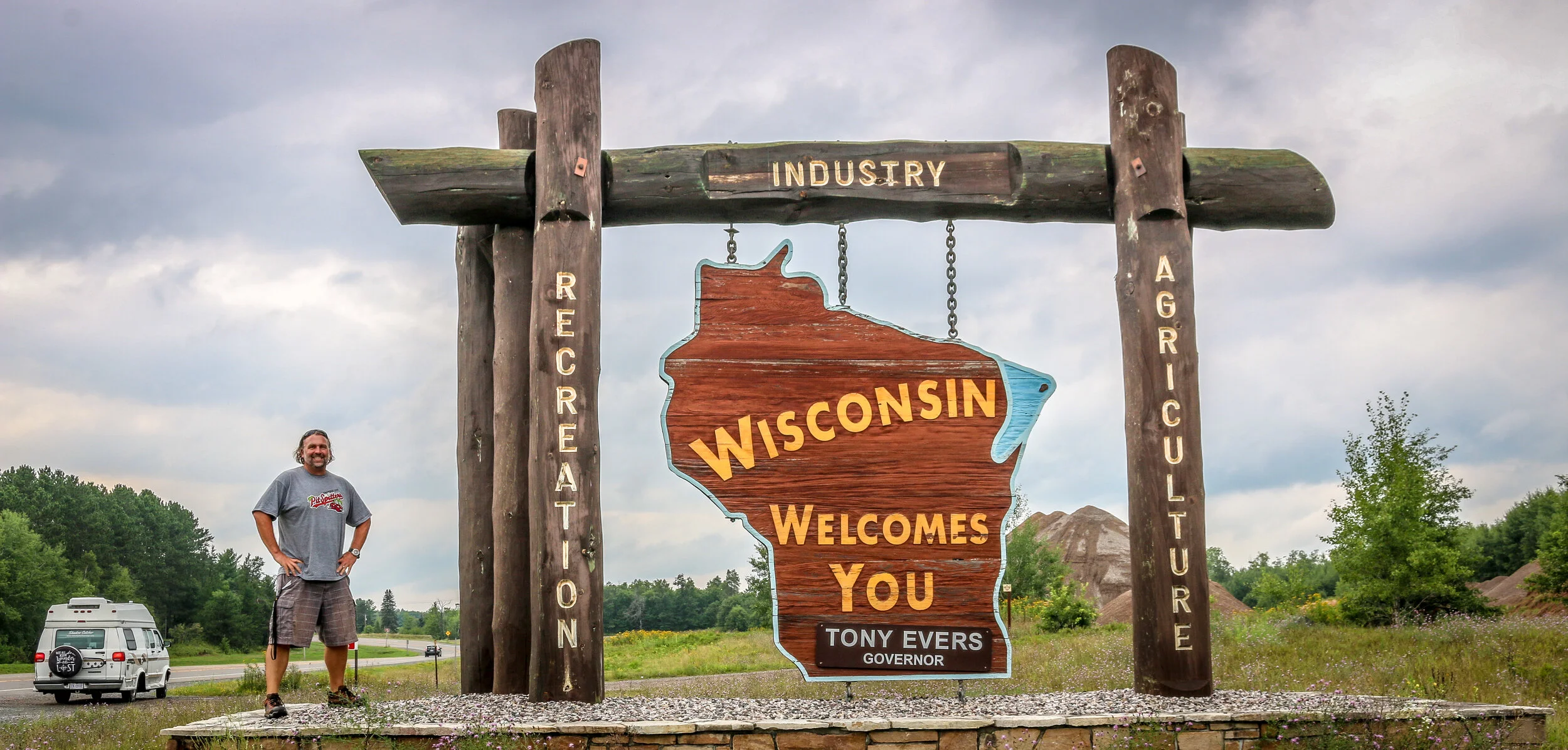
Hello Everyone and greetings from Green Bay, Wisconsin! I have completed my two month journey through Michigan and have moved on to the Badger State. I spent the first half of the week out in beautiful Isle Royale National Park, a destination I was really looking forward to and which definitely lived up to my expectations. Returning from the park on Saturday, it was time for me to make tracks and get myself into Wisconsin. Summer is passing quickly and I still hope to get through both Wisconsin and Minnesota before winter sets in. It’s been a good week, and I’m excited to tell you what I’ve been up to.
I headed out to Isle Royale on the Isle Royale Queen IV out of Copper Harbor bright and early on Wednesday morning. There are three boats that make the trip to the island, and this one just worked better with my schedule. It was fast and made the 55 mile crossing in about 3.5 hours and I enjoyed chatting with a mother and daughter who I sat with on the way out. The mother owned the rock shop in Copper Harbor and had a grandfather who once lived and worked as a fisherman on Isle Royale. Her daughter was in Copper Harbor for the summer and working at one of the restaurants in town. I was surprised by how many people I met who had family connections back to Isle Royale before it became a National Park.
When we arrived on the island, the rangers gave us their briefing, issued backcountry permits and we were off and running. Most of the park is designated wilderness, so unless you are staying at the lodge near the ferry dock you are on your own for the duration of your stay. I shouldered my pack and made my way a little over 7 miles to Daisy Farm Campground on the east side of the island. It’s been years since I’ve carried a full pack that distance, but I have been doing a lot of walking and hiking and it really wasn’t too bad. I even saw my first of nine moose I would see during my visit on this hike. Because I was there alone, it was easy to hear footsteps which weren’t my own and an adult moose has some pretty heavy footsteps. I was able to see the moose through the dense forest and enjoyed spending some time with her before heading on to camp where I took up residence in one of the shelters they had there. I had my tent with me, but since the shelters were available it seemed like an easier option even though it only takes 5 minutes to set up my tent. I had my first dehydrated meal in many years, something which has improved dramatically since the last time I ate one. It was a beautiful campground right on the lake and even though it was pretty busy, people were spread out and it didn’t seem crowded. I met some really nice people in camp and found it easy to talk to people as we obviously had shared interests in hiking, camping and/or National Parks and had gone to some length to get to this remote island.
Stretched between the towns of Munising and Grand Marais along the shores of Lake Superior in Michigan’s Upper Peninsula, Pictured Rocks National Lakeshore is a magical place filled with breathtaking scenery. From historical lighthouses to picture-perfect waterfalls, this small and often overlooked unit of the National Park Service is sure to have something for everyone. I enjoyed hiking many miles of trails along beaches and through the woods, past the waterfalls and overlooks that have captured peoples’ attention for hundreds of years. During the lumbering era, the area was clear cut, but the forest has regenerated in the last hundred years and is healthy again. It’s no wonder that Pictured Rocks was America’s first National Lakeshore, gaining this new designation in 1966. Pictured Rocks National Lakeshore is a must-see while visiting Michigan’s Upper Peninsula and a definite highlight of my time in the state. To truly see the rocks themselves, you do need to get on a boat and see them from the water. I chose the Sunset Spray Falls tour with Pictured Rocks Cruises and while I think the boat could have been better suited to sightseeing, it was a wonderful cruise nonetheless. If you’re ever traveling across northern Michigan, definitely plan on spending a day or two in beautiful Pictured Rocks National Lakeshore. You’ll be glad you did. I hope you enjoy these photos from my visit.
Sleeping Bear Dunes National Lakeshore was designated by Congress in 1970 to protect the wonderful dunes and historic towns on the Lake Michigan shoreline between the towns of Frankfort and Glen Arbor. This region of Michigan is an absolutely beautiful stretch, with remarkable landscapes perched high over the magnificent lake. The park gets its name from an old Ashininaabek Indian story about a mother bear and her two cubs who were starving in Wisconsin and set out to swim across Lake Michigan. The way was long and the two cubs couldn’t make it. They went under and returned to the surface as the Manitou Islands. The mother bear barely made it and climbed up the dunes and turned into a dune herself, forever perched on high looking out at her two lost cubs. The scenic drive will take you to some of the best lookouts in the park including a view of the Sleeping Bear Dune, while two campgrounds allow for wonderful overnight adventures. The old town of Glen Haven tells the story of logging and industry in the area as well as early tourism. The park also covers North and South Manitou Islands, two beautiful islands an hour offshore. I had the pleasure of spending two nights on South Manitou Island and it was one of the top highlights of my whole two month visit to Michigan. The island is basically uninhabited save for a few rangers and a small handful of others, but toads, chipmunks and snakes abound. You can even find a grove of ancient cedar trees in the interior of the island. With the deepest natural harbor between Chicago and Buffalo on the Great Lakes though, South Manitou Island was once a busy place, and some of the old buildings around the island are very well maintained. I loved the old homesteads, the cemeteries and, of course, the lighthouse. In 1970, the ship Francisco Morazon ran aground off of the south shore of the island and while the crew was saved the boat still rests were it hit and is visible above the waterline. While the island is designated wilderness and camping is the only overnight option, you can visit the islands as day trips as well and tours are offered. I had a wonderful stay in Sleeping Bear Dunes National Lakeshore and highly recommend it if you are in this part of Michigan. I hope you enjoy these photos from my visit to Sleeping Bear Dunes and South Manitou Island.