The Ojibwa Indians called Isle Royale “Minong” meaning “a good place to be” and they certainly hit the nail on the head with that one. Isle Royale National Park consists of Isle Royale itself and over 400 smaller islands making up an archipelago in the middle of Lake Superior. Isle Royale is the largest natural island on Lake Superior and the second largest in the Great Lakes at 45 miles long and 9 miles wide. Some of Michigan’s earliest copper mines were established on Isle Royale in the 1840s, continuing the Ojibwa copper-mining tradition which stretched back hundreds of years. Commercial fishing operations also ran off of Isle Royale for many years, but it was the island’s beauty and ability to attract tourism which would create its lasting industry. Isle Royale National Park was established in 1940 and it was made a part of the UNESCO International Biosphere Reserve in 1980.
I had a wonderful 4 day/3 night visit to Isle Royale in the beginning of August. The island is only accessible by boat or plane, with ferries originating out of Houghton and Copper Harbor in Michigan and Grand Portage in Minnesota. I chose the Isle Royale Queen IV out of Copper Harbor which dropped me off in Rock Harbor on the island’s northeast side in about three and a half hours. After getting my backcountry permit from the ranger there, I headed off into the wilderness for the next three nights, staying at Daisy Farm, Lynn Cove and Three Mile campgrounds. I hiked about 25 miles during my time on Isle Royale and really found the island to be a beautiful place to be. After hiking all day, an afternoon dip in Lake Superior always felt great. I saw 9 moose during my visit and also a handful of beavers along with plenty of birds and toads. I really cherished my time on Isle Royale and hope you enjoy these photos from America’s least visited National Park.
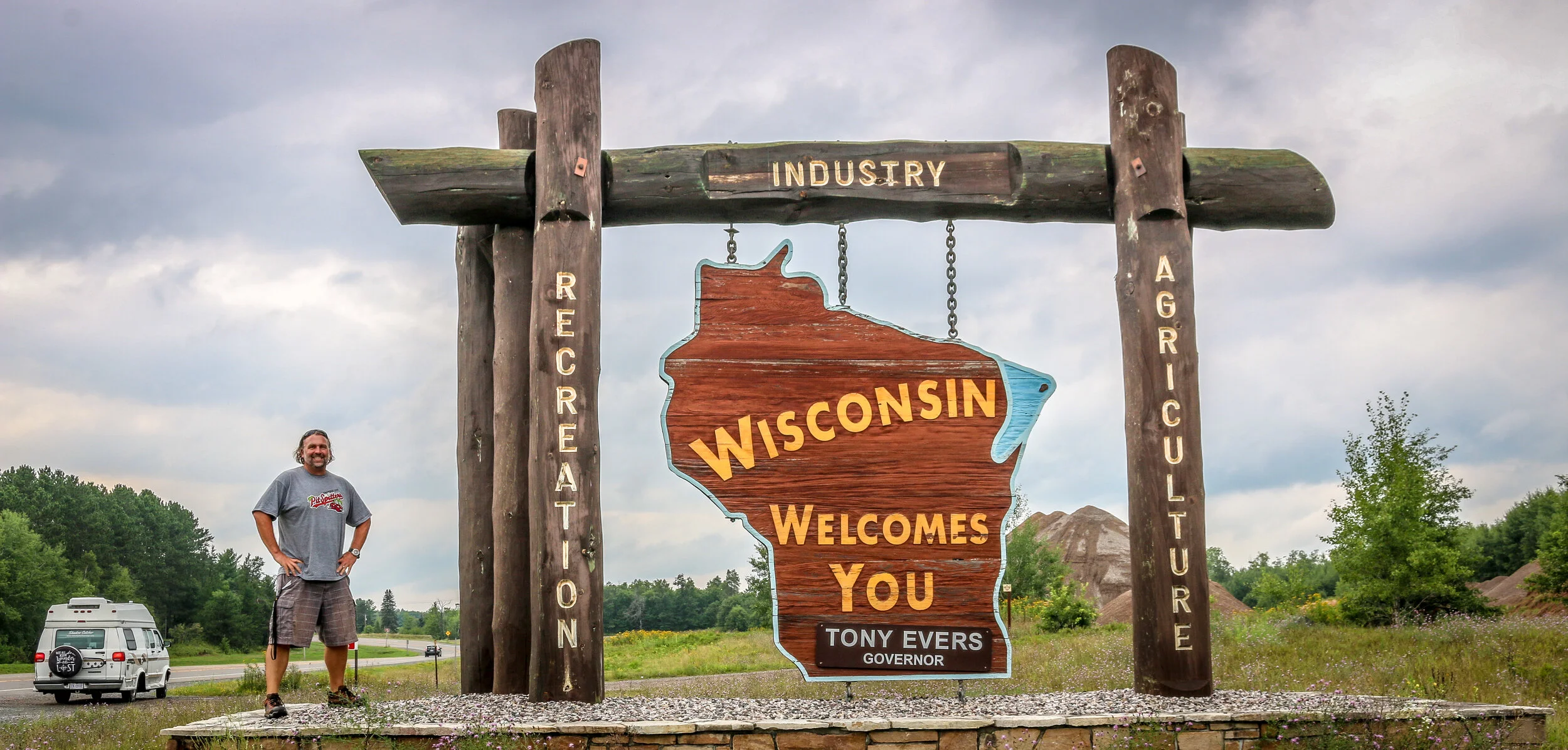
Hello Everyone and greetings from Green Bay, Wisconsin! I have completed my two month journey through Michigan and have moved on to the Badger State. I spent the first half of the week out in beautiful Isle Royale National Park, a destination I was really looking forward to and which definitely lived up to my expectations. Returning from the park on Saturday, it was time for me to make tracks and get myself into Wisconsin. Summer is passing quickly and I still hope to get through both Wisconsin and Minnesota before winter sets in. It’s been a good week, and I’m excited to tell you what I’ve been up to.
I headed out to Isle Royale on the Isle Royale Queen IV out of Copper Harbor bright and early on Wednesday morning. There are three boats that make the trip to the island, and this one just worked better with my schedule. It was fast and made the 55 mile crossing in about 3.5 hours and I enjoyed chatting with a mother and daughter who I sat with on the way out. The mother owned the rock shop in Copper Harbor and had a grandfather who once lived and worked as a fisherman on Isle Royale. Her daughter was in Copper Harbor for the summer and working at one of the restaurants in town. I was surprised by how many people I met who had family connections back to Isle Royale before it became a National Park.
When we arrived on the island, the rangers gave us their briefing, issued backcountry permits and we were off and running. Most of the park is designated wilderness, so unless you are staying at the lodge near the ferry dock you are on your own for the duration of your stay. I shouldered my pack and made my way a little over 7 miles to Daisy Farm Campground on the east side of the island. It’s been years since I’ve carried a full pack that distance, but I have been doing a lot of walking and hiking and it really wasn’t too bad. I even saw my first of nine moose I would see during my visit on this hike. Because I was there alone, it was easy to hear footsteps which weren’t my own and an adult moose has some pretty heavy footsteps. I was able to see the moose through the dense forest and enjoyed spending some time with her before heading on to camp where I took up residence in one of the shelters they had there. I had my tent with me, but since the shelters were available it seemed like an easier option even though it only takes 5 minutes to set up my tent. I had my first dehydrated meal in many years, something which has improved dramatically since the last time I ate one. It was a beautiful campground right on the lake and even though it was pretty busy, people were spread out and it didn’t seem crowded. I met some really nice people in camp and found it easy to talk to people as we obviously had shared interests in hiking, camping and/or National Parks and had gone to some length to get to this remote island.
Stepping off the ferry on Mackinac Island is like stepping back in time. I’m sure that line has been used a million times, but it’s true. Way back in 1898 the city council banned “horseless carriages” from the entire island and that ban remains in effect today. Everything on the island is delivered and transported by horse-drawn cart or bicycle. This alone makes Mackinac Island special, but there’s so much more to this little corner of the world than its lack of cars.
Native Americans traveled back and forth to Mackinac Island for hundreds of years, by canoe in the warmer months and over the ice when the lake froze over. It became an outpost for the French fur trade in the 1700s and remained under French control until the end of the French and Indian War, at which time the British flag was raised on the island. During the American Revolution, the British moved Fort Michilimackinac from its former position on the mainland to a bluff high on top of Mackinac island. After the war, American troops occupied the fort, but a surprise attack during the opening days of the War of 1812 put it back in British hands. The Treaty of Ghent would return Mackinac Island to the Americans in 1815 and John Jacob Astor would soon set up his American Fur Company on the island.
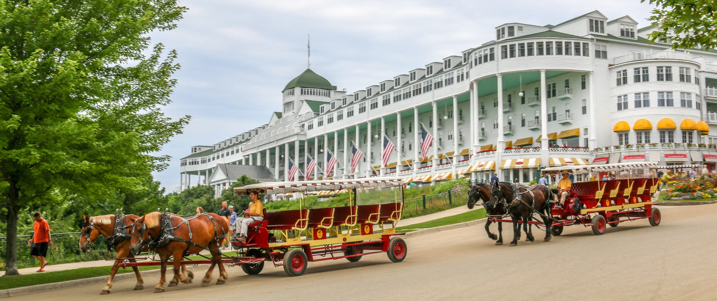
After the Civil War, tourism boomed on Mackinac Island and it was named America’s second National Park with the army unit at the fort charged with the park’s protection. To accommodate the new influx of tourism, hotels were built including the incredible Grand Hotel which still sits high on a hill overlooking Lake Huron. Mackinac Island remained a National Park for twenty years, after which time it was turned back over to the state of Michigan and became Michigan’s first state park.
Today, Mackinac Island is one of Michigan’s top tourist destinations. While the population of the island is less than 500, as many as 15,000 visitors a day descend on the island in the middle of summer. I can certainly understand why as it is a truly beautiful and unique place. I arrived on the first ferry of the day and left on the last, so I did get to see the island in a fairly quiet state. The weather and photography conditions weren’t the best when I was there, but Mackinac Island is so photogenic that I took hundreds of photos anyway and included some of my favorites in this post. I haven’t captioned them all, because many are just of Main Street with horses and carriages but that was such a wonderful scene that I couldn’t help myself. I hope you enjoy these photos from beautiful Mackinac Island, definitely one of my favorite places I visited in my two months in Michigan.
Cheboygan was incorporated in 1871 and grew up around the timber industry, supplying wood for the westward expansion of the country. Located at the confluence of the Cheboygan River and Lake Huron, the town became known as the “Gateway to the North”, although now it goes by “Historic Rivertown” as well. Because of its location and proximity to the Mackinac Bridge and Mackinac Island, Cheboygan certainly sees its fair share of tourism, yet it maintains its small-town feel and felt more like a real, lived in town than many of the places I visited in the state. With two beautiful lighthouses and as the home port of the Coast Guard Icebreaker Mackinaw, Cheboygan maintains its maritime history as well. I had a wonderful time in Cheboygan and only captured some of the beautiful places the town has to offer, but it’s definitely a town worth seeing - ether as a less touristy gateway to the region or in its own right. I hope you enjoy these photos from my time in beautiful Cheboygan.
Hello Everyone and greetings from Copper Country. I’m coming to you this week from the Keweenaw Peninsula – the northern peninsula of Michigan’s Upper Peninsula. This area is known historically for its incredibly rich copper loads which were mined from the 1840s right up until World War II. The towns up here certainly have traces of their former glory, though when the copper industry left, so did most of their economy. Today they depend more heavily on tourism as people come here for mining history and beautiful Lake Superior beaches in the summer and hunting in the fall. It’s a fascinating region and one that I’ve really been enjoying. I actually came up here once or twice as a kid with my dad, so there is some vague familiarity to it, but it’s definitely all new ground for me as an adult. When most of y’all are reading this, I’ll be out on Isle Royale where I’ll be spending three nights in America’s least visited National Park. I’ve been looking forward to going to Isle Royale for a very long time, and I hope to come back with some great photos and stories to tell. Since I’ll be catching the ferry bright and early Wednesday morning, I’m going to finish up with this week’s This Week post a little earlier than usual. That being said, even with a short week, I’ve certainly seen and done a lot so let me tell you what I’ve been up to.
When I left you all last week I was on my way out of Munising after two wonderful days in Pictured Rocks National Lakeshore. I headed south from there to Manistique, a pretty little town on the northern shores of Lake Michigan. I got there just before it started to rain and it rained through the night. I spent the night at the casino just outside of town and won about $50 playing quarter keno.
Thursday morning was gloomy so I was in no big rush to get up and moving. When I did I went down to the beach to eat my breakfast and then wandered out on the breakwater to see the Manistique Lighthouse, which is still active. Dark red in color, the lighthouse really stood out against the grey background of the sky. I took a quick dip in the lake which woke me up more than my coffee did and then headed out of town. I ventured up to Palms Book State Park, home of Kitch-iti-kipi Spring, the largest of Michigan’s freshwater springs. Big Spring, as it is also called, pumps out 10,000 gallons of water every minute at a constant 45 degrees Fahrenheit and is about 40’ deep in the center. The water is a beautiful greenish turquoise and was really quite something to see. The park loads passengers onto a huge raft with a glass floor in the middle so people can look down into the spring, but there were so many people there in line that I decided to pass. I enjoyed the view from the shore and will wait for the raft adventure for another time.
From there I headed out onto the Garden Peninsula which juts out into Lake Michigan and protects Big Bay de Noc on its western side. About 20 miles down on the bay side is Fayette State Historic Park which I thought was really cool. During the second half of the 19th century, Fayette was an iron smelting town, turning raw iron ore into pig iron in its giant furnace. The town attracted immigrants to work at the furnace and in its heyday had a population of around 500. When the furnace shut down in the 1890s, the town was all but abandoned except for the hotel which operated until World War II and the post office which served the area until the 1950s. The town was eventually acquired by the state of Michigan and now serves as an historic site interpreting life in a 19th century company town. Some of the old buildings are still standing, some have been restored or rebuilt altogether while some are nothing but ruins. By the time I reached Fayette, the weather had cleared and it turned into a beautiful day – perfect to explore this old town site. I thought it was a really interesting place and definitely worth a visit.
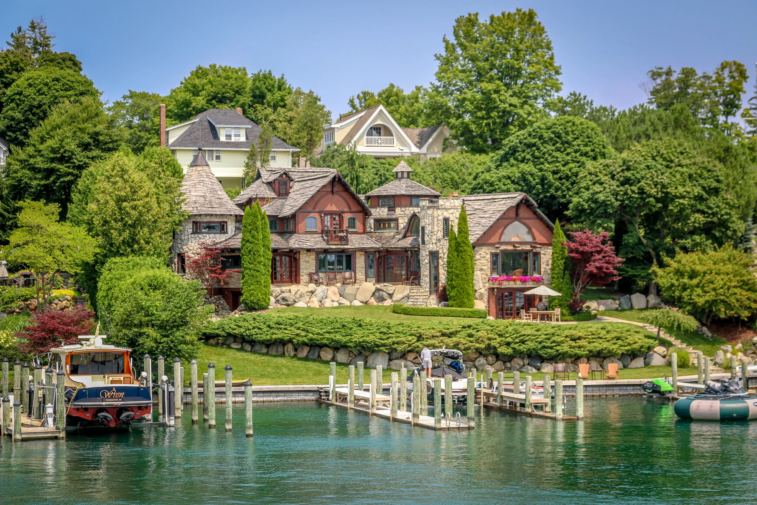
Tiny Charlevoix, Michigan, is named for the Jesuit priest and missionary Father Pierre François Xavier de Charlevoix. It’s certainly one of the more beautiful town names in the state and the town lives up to it well. Situated between Lake Michigan to the west and Lake Charlevoix to the east, it definitely has a maritime feel to it, but more yacht than fishing boat if you know what I mean. In 1918, self-taught architect Paul Young began building fairy-tale houses in the town, some shaped like mushrooms and some more like Hobbit houses. Young’s houses are mostly grouped into two neighborhoods and are really something to see. Other houses and businesses in town have drawn from his style and I also enjoyed seeing them. Charlevoix is also the jumping-off point for ferries to Beaver Island, which is why I was in town. The downtown area is compact but pleasant with some wonderful little bars and restaurants, but the real beauty lays along the lakeshores. Charlevoix also hosts the Venetian Boat Festival every year which looks like an amazing event I’d love to see for myself. The mural on the side of the Rexall downtown is one of the most beautiful I’ve seen anywhere. I hope you enjoy these few photos from my time in the aptly nicknamed Charlevoix the Beautiful.
Grand Haven is a beautiful town of about 10,000 people located on the shores of Lake Michigan at the mouth of the Grand River. It’s history is similar to that of many of the towns I’ve written about coming up the Lake Michigan coast. Originally inhabited by the Potawatomi people, it was later visited by French fur-trappers and then settled in the mid-19th century as a lumber town and shipbuilding site. Today it has a strong Coast Guard presence and hosts an annual Coast Guard reunion which brings people from near and far. Grand Haven also has a huge tourism industry as visitors come to enjoy the beach, the lighthouses, watersports and the pleasant downtown. I had a wonderful visit to Grand Haven and was especially fond of the double lighthouse and the beautiful sunsets over Lake Michigan. I hope you enjoy these photos from my visit to Grand Haven, Michigan - the Jewell of Ottawa County.