Viewing entries tagged
Hiking

This Week on the Road - February 24-March 4

Comment

This Week on the Road - February 24-March 4

Chilling on my Hill

Beautiful Bryce Canyon

Hello Everyone! It’s been an amazing week out here on the road in southern Utah. I’ve seen some absolutely beautiful country, driven some spectacular roads and visited some amazing archaeological sites. I did have a bit of a stomach bug midweek which wiped me out for a couple of days, but it seems to have passed. The weather has been amazing, the photography opportunities plentiful and it’s just generally been a good week all around.

Wide Angle Look at Bryce Canyon in the Snow

I left off last week in Panguitch, a cute little town about half an hour west of Bryce Canyon National Park. When I finished up last week’s post, I wandered around town for a bit and then made my way on into the park. I’ve been to Bryce at least 50 times in my life and it never ceases to amaze me. The view from one of the many overlooks on a sunny day will rival any view, anywhere in the world for natural splendor and beauty. It truly is nature’s little fairyland. The sandstone spires of Bryce, called “hoodoos”, are mostly the result of the extreme temperature fluctuations Bryce sees during the year. Located above 8000’, it’s not unusual to have freezing temperatures any day of the year, but it can be sunny and warm and beautiful any day as well. It’s the cycle of freezing and thawing which has helped shape the landscape more than wind or flowing water. Bryce Canyon is named after Ebenezer Bryce, who you may remember built the Pine Valley Chapel which I wrote about two weeks ago. He and his wife homesteaded in the area in the 1870s and he spent many months digging a canal to funnel the water to the valley below. When asked about the canyon which would forever bear his name, Bryce was once quoted as saying “it’s a hell of a place to lose a cow”. It most certainly would be. It was quite icy out on the trails this time through, so I settled for a few nice views from the rim. After the sun went down I enjoyed a warm seat by the fire out at Ruby’s Inn, just outside the entrance to the park, where I read my book for a while before calling it a night.

Dusk at Bryce Canyon

Appropriately for the day, I am currently reading a book titled A Hell of a Place to Lose a Cow by Tim Brookes which takes its title from that Bryce quote. It’s a book I’ve read before, but not in some time, about Brookes’ attempt to recreate a hitchhiking trip he had made in 1973 around the U.S. Written in 1998, it is of particular interest to me because the U.S. he is describing in the book is the one I first set off into in the summer of 2000 when I left the east coast and became a cross-country tour guide. Some places, like Bryce Canyon, haven’t changed much in the interim. Some places, like Las Vegas, are completely different. He doesn’t seem to do much hitchhiking though, as he catches a lot of busses and rides along with his photographer. He even rents a car at one point.  I’m about halfway through the book and he has completed his east to west journey from New York to California in just 11 days – not much time to stop and smell the flowers. Both he and his photographer seem bored most of the time and can’t seem to find anywhere of interest (except for Bryce Canyon which they both really enjoy). Of course the America they are seeing is the truck stops and diners located off of the main interstates of the country, not the small towns and state parks off of the beautiful scenic byways I tend to stick with. There are so many books about smashing across the country and not really getting to know it at all. Anyways, it’s an interesting read and an easy one, even if I see more in a week than he did in his entire journey.

Morning in Bryce Canyon

I dipped back into Bryce on Tuesday morning to grab a few snowy photos of the hoodoos, and then headed off along scenic Route 12 across the middle of the state. I stopped briefly in the town of Escalante to learn more about the Hole in the Rock Expedition of 1879-80. In 1879, a group of hearty Mormon pioneers set off to build a wagon road from Escalante to the San Juan River, over some of the most daunting terrain in the state. When they made it to the Colorado River, about halfway to their destination, they found themselves more than 1800’ above the river with no easy way down. They blasted a pathway through the rock, but the descent was at a tremendous 45° angle. The first wagon to attempt the drop through this hole in the rock had blind horses, which didn’t know to protest, and a dozen men behind it trying to control the speed with the wagon’s back wheels locked to prevent a runaway. The whole party made it down safely, and continued on to the San Juan where they built the community of Bluff. The Hole in the Rock expedition is a great story in both American and Mormon history. The historic site in Escalante tells this tale and has some beautiful paintings of the expedition and I really enjoyed learning about it there. My friend was telling me that if you see a tombstone in a Mormon cemetery with a wagon on it, it’s a member of the Hole in the Rock Expedition.

Amazing Fremont Pictograph near Lower Calf Creek Falls

From Escalante, I continued into Grand Staircase Escalante National Monument, a sprawling stretch of Utah which encompasses tremendous scenery all around. It’s not an easy place to photograph, but it is an incredible place to drive through. I made a stop at an overlook next to the highway to see the “100 hands” pictograph panel which is exactly what it sounds like – an old Indian cliff painting of more than a hundred handprints. Who made the panel and what did it mean are both questions lost to history, but it was really cool to see (it was too far away to photograph but I found a similar panel a few days later in Capitol Reef which I got right up close to). Just up the road from this panel, I stopped in to hike to Lower Calf Creek Falls, one of southern Utah’s only real waterfalls. I really loved this hike, the falls at the end, and a wonderful Fremont Indian Pictograph of three characters holding hands along the way. The trail was surprisingly busy for this time of year, but it was a reasonably flat 5 mile round trip and it is one of the most accessible hikes in the park. By “busy” I probably saw a dozen people, but relatively speaking, that was a lot. The hike took more out of me than it should have and I was feeling weak and really tired by the time I got back to my van, so I decided to just grab a campsite there and call it a night.

Beautiful Capitol Reef National Park

I wasn’t feeling great when I woke up, either, but I packed up and pushed on up the road to Anasazi State Park in Boulder. This park has a small Indian ruins site out back and a modern re-creation of what the site might have looked like 800 years ago. It also has some wonderful pottery and baskets inside the museum and interprets the time in which this site was occupied. It was a nice little museum with a great little gift shop and worth a stop. From there, I continued on up the road to Capitol Reef National Park. I stopped and took a few photos on the western approach and then cruised into the main part of the park, where I grabbed a campsite in the old Mormon settlement of Fruita (now an historic site within the park). Fruita is aptly named as there are orchards everywhere in sight and this was once an important agricultural area which supplied fruit and vegetables across state. Still not feeling well, I tucked myself in and called it a night.

The Waterpocket Fold in Capitol Reef

I barely got out of bed on Thursday I was so weak. The only time in my life I have felt so fatigued for no good reason was the first time I had Covid, which is what I was afraid this was. Despite the fatigue, I had no other real symptoms though – no congestion, no respiratory issues, no nothing. I thought maybe I had caught something from the shared tongs and spoons from the salad bar I had eaten at in Bryce, but now I’m pretty sure it was from the food itself. I spent pretty much the whole day in bed, watching movies and feeling sorry for myself. Being sick is never fun, but being sick in 20 square feet of living space is certainly worse. Thankfully the weather was amazing, neither too hot nor too cold but just right for the whole day. I tried to go for a walk in the evening to get some air and some exercise and it seemed to help, but not much.

Capitol Reef’s Hickman Bridge

I was definitely feeling better on Friday, so I packed up and set out to salvage what I could of my visit to Capitol Reef. I drove the scenic road and took two short but amazing walks. The first took me up to Hickman Natural Bridge – a huge rock bridge which you can walk right up and under. The second took me down the Grand Wash, the major canyon which cuts through the middle of the park. It was awesome to walk between the walls which towered a thousand feet above me and the shadows kept it cool and pleasant. I had wanted to see so much more of the park and hike, hike, hike all day, but it was time to move on and I was glad to be feeling better and to have at least seen a bit more than I had in the past.

Goblin Valley at Dusk

From Capitol Reef, I cruised on up Highway 24 all the way to Goblin Valley State Park. This is another park I have been to several times over the years, but always in the middle of the day and in the middle of the summer when it’s really too hot to do very much. I arrived with a little over an hour before the sun went down and really enjoyed walking out among the “goblins” – little sandstone formations that definitely resemble little creatures of the night. The sun was at a good angle to light the goblins up with a lovely, warm glow and it was really nice to be there. After the sun went down, I cruised just outside the park where there are some really great free camping spots on the adjoining BLM land. The sun and the exercise had done me well and I was feeling back up to about 80% by then which was a relief. I had planned on heading out the next morning, but I got an email that night from my old friend Jack who had been the training manager at my tour company for many years. He had literally written the book on hiking in the southwest, or at least the manual which we still use today, and he told me that given the opportunity I should spend a whole day in Goblin Valley, “wandering and wondering” as he put it. I spent some time looking into it and decided to do just that.

Goblins Watching the Sun Set

Not wanting to pay another $20 to get into the park in the morning (Utah state parks are quite pricey), I parked outside the main entrance and walked in for $5. I headed off from there on the Grand Circle Trail out into the desert. I circled the formations which serve as the backdrop to the main amphitheater and made my way to two caves on their back side: the Goblin’s Lair and the Goblette’s Lair. Both were really cool, but I particularly liked the Goblette’s Lair as the entrance made for some amazing photos from inside looking out. From there I headed back around and through the amphitheater of goblins and then on towards the Toadstools. I crossed into the wilderness area where the trails disappeared and came across a sign warning of quicksand ahead. When I was a child I definitely thought I would either die by being sucked into quicksand or by being locked away forever inside some ancient tomb or pyramid, both of which I believed existed not far from Washington D.C. Thankfully, I have managed to survive thus far without falling prey to either and I intended to continue that streak at least through the year. I didn’t get stuck in any quicksand, but the ground was soft out there and strange to walk on, and I definitely felt like I was out on an amazing adventure (albeit within whistling distance of the main road in an emergency). The area where the Toadstools were was really cool and I ended up on top of Curtis Bench which led me back to the road and out of the backcountry. The “adventure” of this hike took place mostly in my imagination, but it was an incredibly fun one nonetheless, and it was really beautiful out there.

Wild Horse Butte in Goblin Valley

In the afternoon, I made my way out of the main section of the park and down the road to the entrance of Wild Horse Canyon, a really cool slot canyon just 10 minutes away. Slot canyons have gotten more and more popular of late thanks to social media, and I was surprised at how many cars were there at the trailhead. As I made my way into the canyon, the walls got closer and closer together and the trail narrowed down to where my boot wouldn’t sit flat on the ground. It was really fun and quite beautiful in there, but it was a little too narrow for me at that time of the day when my patience wasn’t at its peak. I’m not a small man, and my shoulders would have gotten jammed if I had tried to go through facing forward. I probably went about a mile up the canyon and I’m definitely glad I did, but it had been a long day so I found a good place to turn around and slowly made my way out of the canyon. Heading out of the park before dark that evening, I could be a little more selective as to where I camped for the night. I found an absolutely amazing spot up on top of a hill where I parked and pulled up a seat to watch the sunset. The sky was huge up there and the clouds were awesome and the sunset just seemed to go on and on. Later in the night, the stars were great from up there as well and I felt like the luckiest person in the world to have had such a wonderful day in Goblin Valley. Thanks, Jack – you were absolutely right about an extra day.

Wolverton Mill in Hanksville

In the morning, I sat out on “my” hill for a while and read my book and drank coffee as the day warmed up around me. Finally deciding to pack up and head out, I made my way down to nearby Hanksville. I really wanted to check out the Wolverton Mill, which was definitely worth a visit. Built by Edwin Wolverton in 1921 up in the Henry Mountains, the mill was used to try and extract gold from the local rocks. It was never wildly successful, but Wolverton was known to wander into town with some gold dust in his pocket from time to time. After he died, the mill was abandoned and eventually was moved by helicopter to Hanksville, where it sits behind the BLM visitor center. Wolverton’s family helped restore the mill and it is cool to see how it functioned with intact belts and gears. I also enjoyed the old sandstone church in town and some cool historic cabins as well. Right across from the little grocery store was a wonderful outsider art instillation called the Monster Mountain Museum. This outdoor exhibit included a few dozen creatures constructed from found materials in the area and was really well done and worth a stop. By that time, I was getting hungry and the one main restaurant in town had just opened for the season. Duke’s is an interesting little spot dedicated to the memory of John Wayne, the Duke himself. There’s plenty of John Wayne memorabilia around and some great old photos from Hanksville‘s heyday. I had a tasty beef brisket sandwich and seeing as they’re the only restaurant in the country that serves coke but not diet coke, I had a beer to wash it down.

Crossing the Colorado

I enjoyed my meal and then headed on down the highway. Leaving Hanksville I was on Route 95, the Bicentennial Highway (having been finished and dedicated in 1976). This is one of the few major stretches of road in southern Utah which I haven’t driven before and it was a beautiful ride. About 45 minutes from Hanksville, the road crosses the Colorado River and what was once Lake Powel. The lake is all dried up and even the river is looking pretty low these days, but I still got out to take some photos and have a look around. It was hot out there so I continued on down the road until I got to Natural Bridges National Monument. This is another place which has eluded me over the decades and I was definitely looking forward to finally checking it out on this trip. The park is home to three magnificent rock bridges and was designated a National Monument by Teddy Roosevelt in 1908. There is a scenic drive which brings you to overlooks above the canyon, but to be honest the views aren’t very good from above. You really need to get down into the canyon to really appreciate the bridges. I got to the park in time to go and see the first one on the road – Sipapu Bridge. The hike down to Sipapu Bridge is a fun adventure in itself, going town several ladders and across a cool rock ledge past a small Indian ruin. I loved this little hike and the bridge itself was magnificent, especially in the setting sun. I decided to stay the night in the park’s campground which was hard to beat for $16.

Kachina Bridge

I got up the next morning and headed for the second bridge on the loop road – Kachina Bridge. Leaving my van behind, I dropped down once again into the canyon and made my way up and under this massive bridge. After taking some photos, I proceeded down the canyon on the unmaintained trail between the second and third bridges. The beginning and the end of this three mile stretch were beautiful. The middle part, however, was full of little willow trees which whipped up on my bare legs as I walked. It took a while longer to make my way through the canyon than I had anticipated, but when Owachomo Bridge finally came into view, it made it all worthwhile. This long, narrow bridge is absolutely spectacular especially when viewed from below. Ascending back to the canyon rim, I then had to hike up and over the mesa to get back to my van. Thankfully, this trail was significantly easier to follow and was actually quite pleasant. Except at the overlooks, I didn’t see a single person on the trail for the whole 3 hours I was out there.

House on Fire

I was hungry when I got back to my van, so I enjoyed a quick lunch and then jetted out of the park and into adjoining Bear’s Ears National Monument (having seen the namesake “ears” the day before on my drive in and several times in Natural Bridges). I have spent some time in Bear’s Ears before, but was looking forward to seeing a few more little areas on my way through. My first stop was at Mule Canyon, a restored set of ruins just off of the main road. The highlight of this stop is the circular kiva, which would have served as both a community meeting room and ceremonial room when the village was occupied 800+ years ago. Reconstructed to its believed original appearance and covered by a giant canopy, it didn’t really do much for me personally, but I have seen spectacular Ancestral Puebloan ruins across the region for many years. From the ruins, I headed up Mule Canyon to visit the House on Fire which is just about a mile up the trail. House on Fire is just a small set of ruins, but I really enjoyed my visit. These house ruins are fairly complete and the rock formations they were built under make them look like they are ablaze in the right light. I appreciated that it took at least a modest effort to reach them and also that I had the site all to myself. The day was waning by that point, so I headed back to my van and enjoyed my sunset cruise into the small town of Blanding. It may be small, but after the previous week it felt like a thriving metropolis, especially their wonderful little grocery store. I stocked up on a few things and then had a nice little pizza for dinner before tucking in for the night.

Five Kivas Pueblo

Yesterday morning I started my day with a visit to the Five Kivas Pueblo site which is just 5 minutes from downtown Blanding. This set of Ancestral Puebloan ruins flies under the radar, but I absolutely loved them. You can see the ruins from the parking lot across the canyon and it’s maybe a ten minute walk to get to them, but they are wide open to explore and again, I had it all to myself. These aren’t pristine ruins. The graffiti on the walls dates back at least a hundred years and you can tell more than a few beers have been enjoyed by local teenagers in the ruins over the years. That being said, there was no garbage there and the site seemed well maintained. Sometimes it’s good to really get into something and not feel like you’re in a museum. The ruins have held up well over the years and you can definitely see the outlines of the namesake five kivas. There are a few potsherds and even an old corn cob on a ledge and I found the whole place really enjoyable. I’m definitely glad I found them. Leaving the ruins, I spent some time in Blanding’s community rec center, getting a workout in and a much needed shower before spending most of the afternoon in the library trying to catch up. In the evening I went to the only real restaurant in town and had a delicious Navajo taco. These “tacos” are made with Indian fry bread in place of tortillas and are fairly ubiquitous across the country, having their origin in government rationing which often left Indian tribes with flour and little else. The history isn’t joyful, but the fry bread certainly is and I’m always happy to find it when I’m in Indian country.

Inside Bluff Fort

This morning I got an early start and made a beeline for Bluff, about a half hour down the road. I started my visit at Fort Bluff which is a reconstruction of the town that was built by the pioneers who came down the Hole in the Rock trail I described above. There are still some original buildings around town, but the ones in this “fort” were built in the last 15-20 years, mostly through funds and with artifacts provided by the descendants of the original settlers. I really liked the first cabin which was a tribute to the unfortunately named Dick Butt. The main building in the early days was a trading post with a dance hall on the second floor for community dances and events. A thief had tried to blow open the safe in that building using dynamite, but packed in a bit too much and ended up blowing the safe, the building, and himself to smithereens. That’s instant karma if I’ve ever seen it. The reconstruction of that building now serves as the visitor center and gift shop and has an excellent film about the Hole in the Rock Expedition.

The Incredible Wolfman Panel

After visiting the fort, I continued south and west and then turned up the Butler Wash on a dirt road and followed it for about a mile. I parked my van and headed out into the Wash and after a bit of hunting found the famous Wolfman Petroglyph Panel. This is one of the most impressive petroglyph panels I’ve seen, even more-so because it dates back to the Basketmaker II Era which ended in 750AD. Compared to most Ancestral Puebloan petroglyphs which are simple geometric shapes or basic animal or humanoid carvings, this one looks like it was done by the Indian Picasso. The lines are clean and clear and it’s very impressive from an artistic perspective even though we have no idea what the carver was trying to portray. It was very cool to see. Just up the wash is another small set of ruins which were definitely worth a visit while I was in the area. From there I made my way back to Blanding, where I will finish up this post here in the local library.

March is upon us and I feel like winter is starting to wind down out here. I know I still have some cold days ahead, but it’s time to start making my way north again. I definitely have some fun plans for the week ahead including visits to Arches and Canyonlands National Parks and maybe even Colorado National Monument across the border into Centennial State (this is another park site which has continually eluded me over the years). I imagine I may be in Colorado at this time next week (although I will be returning to Utah for a couple more weeks immediately thereafter). I hope you’ll check back in with me and see what I get up to. I’m really looking forward to it myself. Thank you, as always, for being a part of this journey.

-Mike

Grand Staircase Escalante Geology

Lower Calf Creek Falls

Moonrise Over Bear’s Ears

Chimney Rock in Capitol Reef

The Torrey Church and Schoolhouse

Country Corner in Escalante

Hands Pictograph in Capitol Reef

The Main Amphitheater in Goblin Valley

Chilling in Goblin Valley

Sunset Goblins

Castle Rock in Goblin Valley

Cool Geology Near Capitol Reef

Sunset Clouds Near Goblin Valley

This One Reminds me of a Pagoda

Inside the Goblette’s Lair

Beautiful Clouds Over Utah

Narrow Wild Horse Slot Canyon

Carl’s Critters at the Monster Mountain Museum

Cool Car at the Mountain Monsters Museum

Owachomo Bridge

Sipapu Bridge

I Loved Goblin Valley

Comment

This Week on the Road - September 25th-October 1st

Comment

This Week on the Road - September 25th-October 1st

Hello Everybody! It’s hard to believe it’s October already. The leaves are definitely turning here in Washington State and the stores are filled with skeletons and pumpkins. It’s definitely starting to cool down and the days are getting noticeably shorter. This week has brought me from the heart of spectacular Olympic National Park to the state capital of Olympia with a couple of cool small towns sandwiched in between. I put in another 20 miles on the trail this week which I’m pretty proud of and finally got my views of Mount Olympus. After a couple of weeks of small towns and national park, it was nice to return to the city, although Olympia is hardly a thriving metropolis. I finished off my week with a night off the road in the classic Olympic Club hotel in Centralia. All in all, it’s been another great week on the road and I can’t wait to tell you all about it…

Comment

Snapshots - Sedona - A Hiker's Paradise in the Red Rocks

Comment

Snapshots - Sedona - A Hiker's Paradise in the Red Rocks

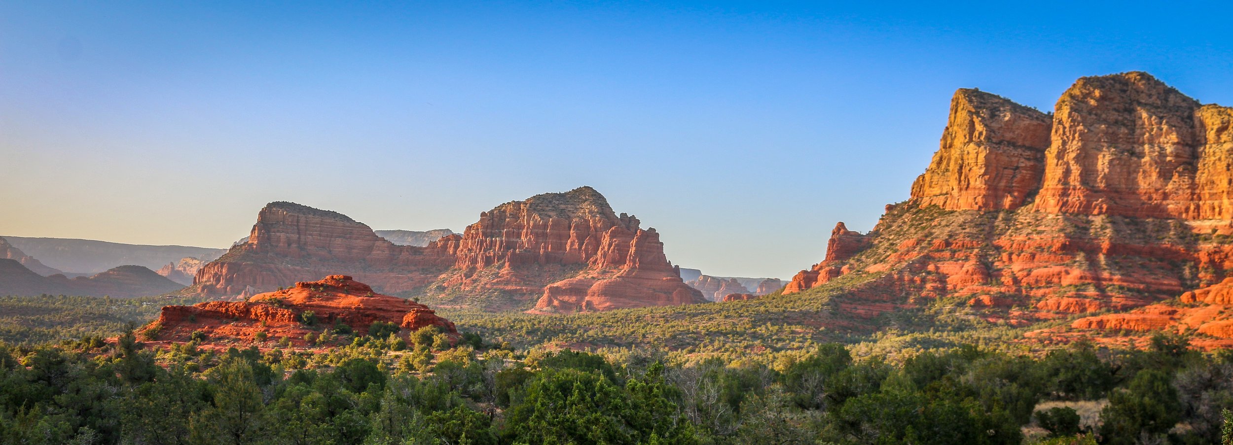
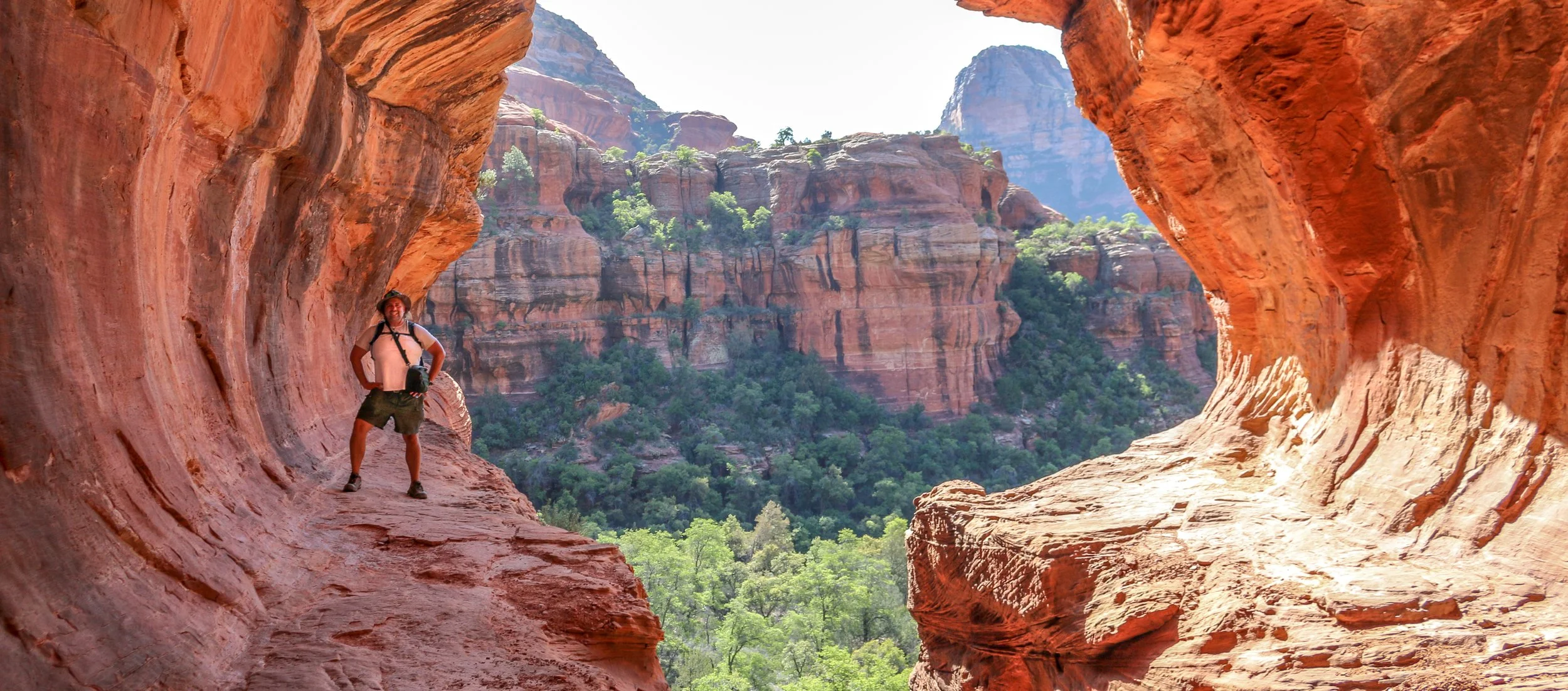
I had spent time in Sedona before, but never enough. I was always there for just a night, usually late in a tour where we didn’t have much time to do more than have a cursory look around. The cost and snobby attitudes of the locals with their spiritual vortex talk was always a turn-off for me. I had never had the chance to really get out there and do some hiking before, but I’m sure glad I scheduled a few days for it on this trip. I’ve been to a lot of places in this country, but few can compare to the red rock country surrounding Sedona. I don’t know about vortexes, but it is definitely a beautiful and magical place. Like most of red rock country, it’s best to hit the trail very early in the morning or just as the sun is starting to go down. While I was there, I hiked to the Birthing Cave, the Subway, Devil’s Bridge, the Courthouse and Bell and, my personal favorite, the Airport Loop. With the exception of this last one, which I had all to myself, there was no shortage of people in the area. It’s definitely not a secret place, nor is it off the beaten path, but it’s well worth it to visit and the shear number of trails in the area helps to disperse people pretty well. I had a wonderful few days in Sedona and will definitely be back. I hope you enjoy these photos from beautiful Sedona, Arizona, a true hikers’ paradise.

Comment

This Week on the Road - July 3rd-10th

2 Comments

This Week on the Road - July 3rd-10th

Hello Everyone! I hope all of my American readers had a fabulous 4th of July. I spent mine in Yosemite National Park, which is a beautiful tribute to so much of what’s right with this country. Ken Burns was definitely onto something when he called our national parks “America’s greatest idea”. This country has had its ups and downs and the pendulum continues to swing, but I’m sure you know by now how passionate I am about our national parks and public lands in general. While there were definitely no fireworks allowed anywhere in the vicinity of Yosemite do to extreme drought and fire hazards, I was happy to spend some of the day in the shadow of the mountain known as Liberty Cap – it seemed quite fitting.

Since I am back to work and will be incredibly busy these next few months, these updates are going to come sporadically throughout the summer and early fall. During the last few years, I’ve tried to get them out pretty religiously on Wednesdays with an excellent success rate, but when I’m working it’s a different story. I’m slowly starting to shake the rust off from three years without guiding a tour and I’ve definitely been enjoying being back on the road and being back on payroll. It’s always good to see my accounts rolling up instead of down. I’ve also loved being back in front of a group, sharing my passion for nature and history and sharing travel stories and laughs over dinner and drinks. I have strangely been asked on two of my first four trips to give a brief overview of the American Civil War. Neither was brief, but I like to think they have a significantly better idea of what the war was about.

I’ve been really hoping to have one trip go off without a hitch as most of my trips did for many years before the pandemic. I’ve always been good at covering my bases so that even when things go wrong, most of my passengers will never know the difference. That’s been hard so far this season, and this current trip was no different. I only had four passengers scheduled on this current trip to Yosemite, but only two showed up on our first night together. Thankfully the other two at least left word as to where they were and by the evening of the second day I had all my ducklings gathered ‘round me. This was another 5 day hiking tour to Yosemite and the weather really couldn’t have been better. It was in the mid-60s to low-70s all week and not a cloud in the sky – perfect Yosemite hiking weather. The snow-melt-fed waterfalls are still going strong and the wildflowers are in full bloom. Once I had all of my passengers with me, I could tell we were in for a wonderful week.

And a wonderful week it was. On Sunday we went for lunch at the Iron Door Saloon, the oldest saloon in California dating back to 1852. Then we went out and hiked to see the giant sequoias, the largest living things on earth. Spending time among the sequoias is always humbling and awe-inspiring. When Jesus walked the earth, some of these trees were already a thousand years old.

Monday found us on the Mist Trail, hiking up 1600’ past the beautiful Vernal and Nevada Falls. This is a heavily traveled route and because of that is one I haven’t hiked in many years. I prefer to spend my time in Yosemite in quieter corners of the park. It has been nice to revisit this hike this season as it was the very first hike I ever did in Yosemite, 22 years ago when I was on my training trip to become a guide.

2 Comments

This Week on the Road - April 28th-May 4th

1 Comment

This Week on the Road - April 28th-May 4th

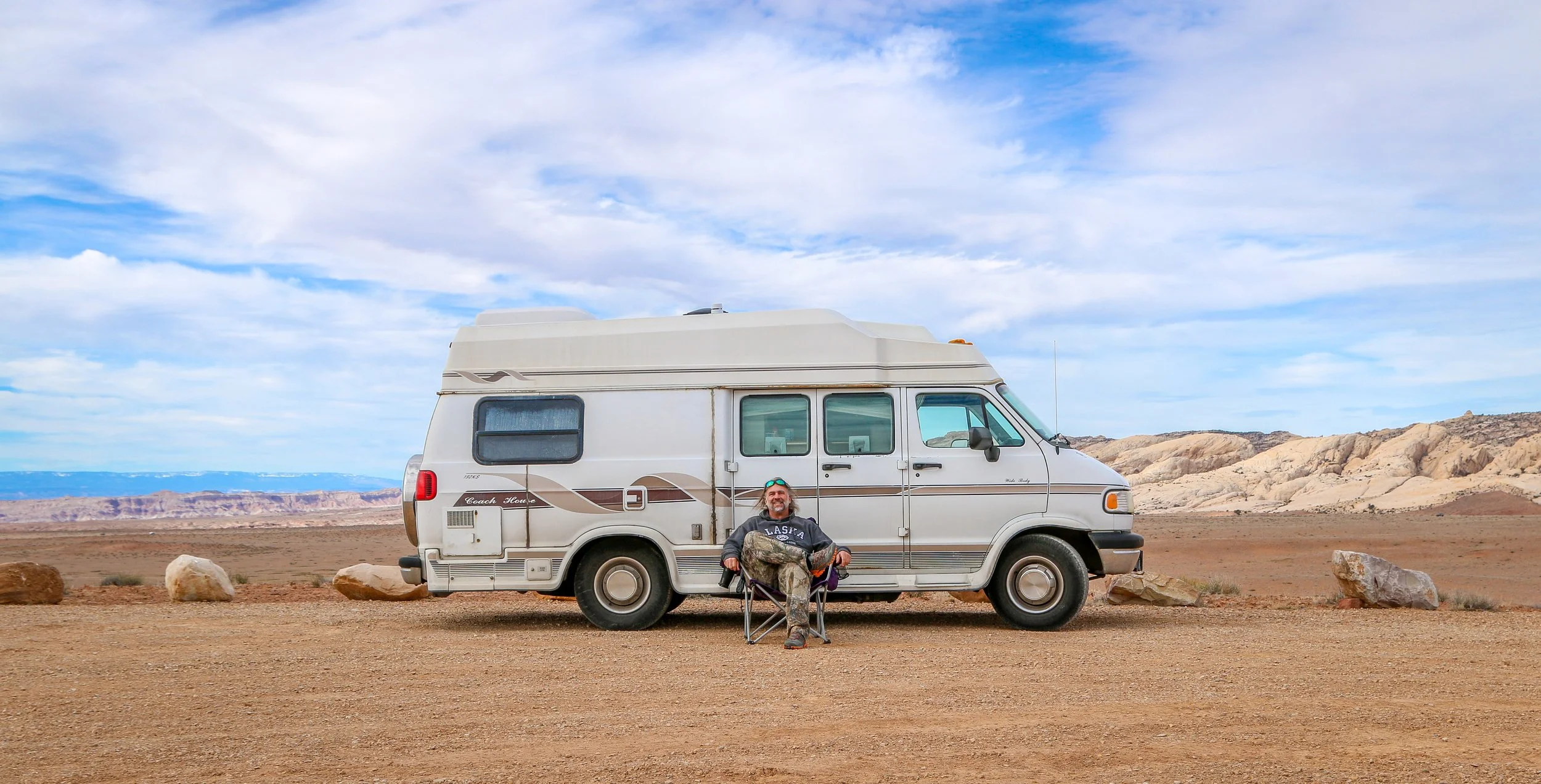
Hello Everyone! It’s hard to believe it’s May, but it definitely is. Even in the middle of the desert, flowers are blooming, bees are buzzing and the days are getting longer and longer. That means it’s almost time for me to go back to work so I can fund these adventures and I’m really looking forward to being back out there guiding tours for a while. That being said, I am hoping to really enjoy these last few days of freedom because guiding is pretty full-on and I know it’s going to be a busy summer. Yesterday was my 5 Year “Vanniversary”, marking five years since I bought Shadow Catcher up in Lansing, Michigan and began this wonderful adventure. We’ve seen good times and bad, but it was definitely the best purchase I’ve ever made and the adventures we’ve had together have been pretty epic. This week has brought us north into central Arizona where I’ve found cooler weather, beautiful landscapes, cute towns and endless miles of hiking trails. It’s really been exactly what I needed and it’s been a pretty great week out here and I can’t wait to tell you all about it.

My hotel night last week was very relaxing and refreshing and I felt significantly better when I headed off to the Diamondbacks’ baseball game Wednesday afternoon at Chase Field. I was a little surprised that the cheapest seats in the stadium were $29, higher than most ballparks, but on the other hand I found free parking nearby and they had inexpensive hot dogs and corn dogs, so it all worked out in the end. The stadium was beautiful and stayed pretty cool as long as you found a seat in the shade. It does have a retractable roof which I guess they save for even hotter days (it got up to about 97° while I was there for the afternoon game). I got a kick out of knowing my uncle and cousin were at a Milwaukee Brewers game this week and they had to close their roof because it was snowing. It was not an action packed game, but the Diamondbacks did pull out a win for their hometown fans. They were playing the L.A. Dodgers and there were a LOT of Dodgers fans there as well. After the game I went and enjoyed a cocktail at Bikini’s, a Phoenix Tiki institution which has been slinging Mai Tais since 1947. It was a nice enough place to stop in for an afternoon drink and then I stopped into Tombstone Brewery for an excellent session IPA and found a nice corner to sip my beer and read my book for a while before calling it a night.

Thursday morning I headed over to tour the Arizona State Capitol, or more accurately the State Capitol Museum. Much like Louisiana and Florida, Arizona has a horrendous 1970s era capitol building, but thankfully, also like those other states, they hung onto their original capitol building and opened it as a museum. The museum had a fascinating display of information and artifacts from the USS Arizona which was sunk in Pearl Harbor in 1941. They had a nice tribute to Sandra Day O’Connor who, while born in Texas, served much of her career in Arizona. They had the phone on display on which O’Connor got the call from Ronald Reagan conveying news of her nomination to be our first female Supreme Court Justice. I was impressed by their lengthy exhibit on Arizona’s World War II Japanese internment camps. I also loved the Arizona Model Railroaders’ room which is a work in progress but had trains pulling through several Arizona towns as they wound their way around multiple levels of tracks. There was also some beautiful Arizona art on display and several smaller exhibits and I found the whole place a very worthwhile visit. Outside of the Capitol are several war memorials which were all beautifully done. When I had finished my visit, I took my book and sat under a nice shade tree and read for a while. Then I headed south of downtown to the home of my old college buddy, John Bushko, who I haven’t seen in 25 years. It was wonderful to meet his wife and children and catch up on all that he’s been up to in the interim. We have a lot of overlap in our Penn State friend circles, so it was fun to hear and to share stories about our mutual friends. They made an absolutely delicious dinner to share with me and we sat out by his pool swapping stories into the night. They definitely left me with a different appreciation of Phoenix and another night in a cool bed was welcome and greatly appreciated.

We were all up early on Friday and enjoyed some coffee and breakfast in between John’s early morning meetings (he works with a lot of people on the east coast, so his day workday starts at 6am). I said my goodbyes around 9 as I wanted to get out of town before the day heated up too much. I headed east through Apache Junction and Superior to Globe, an old mining community with a cute historic downtown and a few great ghost signs on the sides of their buildings. Globe’s old courthouse has been converted into a lovely art gallery and they also had a cool old train engine in one of their local parks. I was there for about an hour and then headed up the hill to Tonto National Monument, an old Sinagua Indian ruin in the middle of Tonto National Forest.

1 Comment