Hello Everyone!
I hope your summer is starting out as great as mine is. The summer solstice is upon us and I’m trying to make the most of the long days. This week I’ve been guiding a trip for two wonderful ladies from San Francisco to Las Vegas via Yosemite, Death Valley, Zion, Bryce, Monument Valley and Grand Canyon. While I definitely prefer guiding a larger group, the three of us have clicked well and have been having a good time out here. We’ve had some windy days, but they’ve also been sunny and bright and of course these parks are truly magical places to spend time.
We left San Francisco early Monday morning and made a beeline for Yosemite. I was happy that route 120 was open again after being closed due to road damage on the final decent into the valley. That closure caused me to detour around to the 140 on my last two trips, which added about an hour to the drive and threw my regular route, landmarks and commentary out the window. It was nice to do things a little differently for a change, but I was happy to fall into my familiar groove on that drive this week. Unfortunately by the time we were dropping into the valley in the afternoon, it had clouded up and there was some rain falling. This should be quite normal for this time of year, but after 20 years of drought it doesn’t feel normal. El Capitan was in the clouds and Half Dome wasn’t even visible. Thankfully the waterfalls were going strong and we stopped at a couple of viewpoints to check them out. The rain slowed to a drizzle and we spent the rest of the afternoon wandering around the old Ahwaneeche village behind the visitor center and visiting Galen Clark’s grave in the old cemetery. Clark came to the valley in 1851 after being diagnosed with consumption (tuberculosis) and having been given just a few months to live. He fell in love with Yosemite and decided to dedicate the rest of his life to preserving it. That life was supposed to be short, so he dug his own grave and planted Giant Sequoia saplings around it. He ended up living another 54 years but was eventually buried in the grave he dug for himself. After I told that story and we paid our respects, we headed to our hotel out in El Portal for the night.
We returned to the valley on Tuesday morning under blue skies and sunshine. Linda wasn’t convinced her knee would hold up on long ascents or descents, so we stayed on the valley floor for the day. We went out to Mirror Lake in the morning which was as full as I’ve ever seen it (it turns into Mirror Meadow pretty early in the summer most years). Then we wandered back to the Ahwanee, Yosemite’s classic park lodge. We had lunch in the Great Room and a nice chat about the afternoon. From there we made our way out to Lower Yosemite Falls which is still raging pretty hard right now and putting out plenty of spray. It’s awesome to spend some time there and the ladies really enjoyed it. Then we headed back to Yosemite Village for a coffee and then back to our hotel for the night.
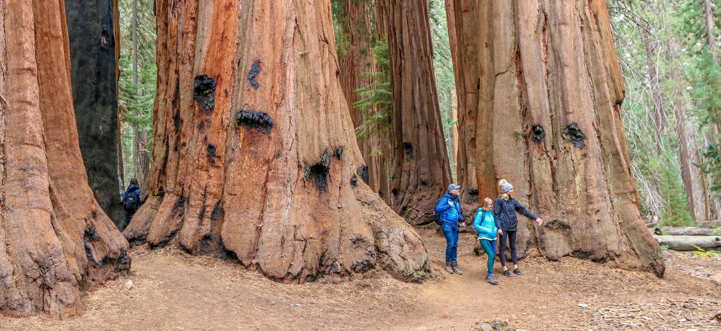
Wednesday was kind of a quiet day. We chose a late start and then made our way down to the Mariposa Grove of Giant Sequoias. The shuttle is finally running again, cutting out the 4 mile roundtrip hike to the grove from the parking lot. We enjoyed our visit to the big trees and then spent some time in historic Wawona, checking out some of the cool old buildings from Yosemite’s past. In the afternoon we returned to the valley for a quick coffee and then made our way back to the hotel. I’d been eating salads for a few days so I decided to grab a pizza which was nice. My knee was giving me some trouble too so I was grateful to be able to ice it and rest for the night.
Since the Tioga Pass over the Sierras is still under many feet of snow and likely won’t open until August, I had to make the long drive around the mountains to get to Death Valley on Thursday. Not only is this route far less scenic, but it also adds 2-3 hours to the drive. It wasn’t a fun or beautiful drive except at the very beginning or the very end, but we got there. I haven’t been to Death Valley in years, and we were greeted with a cool 107° when we arrived…
Hello Everyone!
It’s been a great couple of weeks out here on the road. I spent two weeks guiding a tour for Austin College, a small university based in Sherman, Texas (far from Austin, Texas – the school is named for Texas hero Stephen Austin). The tour was for a class on environmental concerns in our National Parks, a topic quite near and dear to my heart. It consisted of 10 students and their professor and took us from the Sierra Nevada Mountains to the desert. I really enjoyed these young people and I got along really well with the professor, Dr. Baker, as well.
I met the group two weeks ago on a Tuesday night here in San Francisco. They invited me to join them for dinner at House of Nanking in Chinatown which is a pretty cool place to eat as a group and we all enjoyed quite a feast. It was interesting to hear what the students were studying and what their specific area of interest was for this particular class. Their topics ranged from birds to flash floods to water conservation and all of them were really important to our western parks.
We spent the next three nights in Yosemite, hiking and meeting with the rangers to discuss the park’s key issues. There was still a lot of water in the valley and it was great to see everything so wet and green. On our first full day we hiked up the Mist Trail to Vernal and Nevada Falls and there was a ton of water coming over those waterfalls. Everyone got absolutely soaked, but thankfully it was a sunny day and we dried out quickly. The last time I did that hike was last November when those waterfalls were barely a trickle and the trail was completely dry. The next day we went out and hiked to the Giant Sequoias in the Mariposa Grove in the south of the park and it’s always awesome to see these massive 2-3,000 year old giants. In our meetings with the rangers and staff, we discussed fire management and bear conservation and the conversation was quite interesting. Leaving the park we headed south and around the mountains and ended up in Barstow for the night. We did some serious grocery shopping and then enjoyed a nice dinner at Peggy Sue’s 1950s Diner just outside of town. That night we had our first group discussion and I really enjoyed hearing the student’s opinions about Yosemite and what they had seen and heard over the previous few days.
We left Barstow early the next day as we had a pretty long drive to Grand Canyon that day. We stopped in Seligman to get our kicks on Route 66 and then headed on to the South Rim…
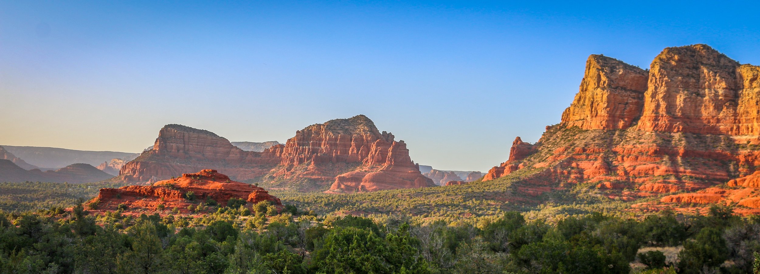
I had spent time in Sedona before, but never enough. I was always there for just a night, usually late in a tour where we didn’t have much time to do more than have a cursory look around. The cost and snobby attitudes of the locals with their spiritual vortex talk was always a turn-off for me. I had never had the chance to really get out there and do some hiking before, but I’m sure glad I scheduled a few days for it on this trip. I’ve been to a lot of places in this country, but few can compare to the red rock country surrounding Sedona. I don’t know about vortexes, but it is definitely a beautiful and magical place. Like most of red rock country, it’s best to hit the trail very early in the morning or just as the sun is starting to go down. While I was there, I hiked to the Birthing Cave, the Subway, Devil’s Bridge, the Courthouse and Bell and, my personal favorite, the Airport Loop. With the exception of this last one, which I had all to myself, there was no shortage of people in the area. It’s definitely not a secret place, nor is it off the beaten path, but it’s well worth it to visit and the shear number of trails in the area helps to disperse people pretty well. I had a wonderful few days in Sedona and will definitely be back. I hope you enjoy these photos from beautiful Sedona, Arizona, a true hikers’ paradise.
The area that is now Wickenburg was once Yavapai Indian land and the river that runs through it is the Hassayampa which means “following the water as far as it goes” in the Yavapai language. In 1863, German prospector Henry Wickenburg came to the area in search of gold. He found it and opened the Vulture Mine which would eventually produce 340,000 ounces of gold and 260,000 ounces of silver.
Ranchers came to the area as well and soon a community sprang up. In 1895, the railroad came through Wickenburg which spawned even more growth. The town was incorporated in 1909, making Wickenburg the oldest Arizona town north of Tucson and the 5th oldest in the state. In 1866, Wickenburg missed being named the territorial capital by just two votes.
Today Wickenburg is a quaint little community with a real wild west feel to it (some of the light posts are even wearing cowboy hats). There are some amazing art installations around town and the Desert Caballeros Western Museum is one of the best in the state. I love the design of the Saguaro Theatre which was also probably my favorite theatre in Arizona. You’re never alone when you’re in Wickenburg as life-like statues are spread throughout town making for a family friendly feel. I hadn’t planned on staying long in Wickenburg, but it’s a great town worth exploring and I was there way longer than I expected to be. Next time you’re in this part of Arizona, stop in for a spell. You’ll be glad you did. I hope you enjoy these photos from tiny Wickenburg - the Dude Ranch Capital of the World.
The area around what’s now Patagonia, Arizona was once a Tohono O’odham village called Sonoitac. It may take its current name from the southern region of South America, christened by Welsh miners who had moved north for work. Another theory is that early settlers found a large footprint, perhaps from a grizzly bear (or Sasquatch himself), and called it “Land of the Bigfeet”. However it got its name, Patagonia is a wonderful little town that’s big on art and seems to have sought to beautify even the smallest details of their town.
When the Spanish moved north into the area, they established the Mission Los Reyes de Sonoitac. The region became part of the United States through the Gadsden Purchase of 1853 and lead and silver mines were quickly opened. Fort Buchanan was established to provide protection for the settlers from Apache raiders, later to be joined by Forts Crittenden and Huachuca.
Father Eusebio Francisco Kino established the Mission San Cayetano de Tumacácori on the east side of the Santa Cruz River in January of 1691, making this the oldest mission site in what is now Arizona. The name “Tumacácori” is an English bastardization of a Spanish interpretation of an O’odham (Pima) word, the meaning of which has been lost. It is how the native people referred to this region. After years of violence at the hands of the Spanish, the O’odham people rose up in the Pima Revolt of 1751. Laying blame on the abuse of the Jesuits missionaries, they were pardoned by the colonial governor and the Jesuits would be expelled from the colonies beginning in 1757. The mission was moved across the river and renamed Mission San José de Tumacácori and the first actual church was built on this new site.
Franciscans would try and pick up where the Jesuits left off and in 1800 they began work on an ambitious new church, trying to match the majesty of Mission San Xavier del Bac to the north (a photo of which appears at the very bottom of this post). The church was never fully completed as the missions were closed when the Mexicans won their independence in 1821. Today, the mission is a part of Tumacácori National Historical Park and a visit is a must when you’re in the area. You can learn more about the O’odham people, the Spanish missionaries and colonial life in the missions and it’s a very cool place for a wander.
Fort Apache was constructed between 1874 and 1932 and served as an important military outpost during the Apache Wars. It rests in the midst of the beautiful White Mountains of Eastern Arizona. and is well situated at the convergence of the North and East Forks of the White River. The area is the ancestral home of the Cibicue and White Mountain Apache tribes who welcomed the United States Army to build the fort there, as they had a common enemy in the Chiricahua Apache. The White Mountain Apache are very proud of their service as scouts in the U.S. Army, and the role they played in the defeat of the Chiricahua and the capture of the great Chiricahuan leader, Geronimo. I learned a lot about the Apache Scouts and their campaigns at the wonderful "Nohwike' Bagowa" (House of Our Footprints), more commonly referred to as the Apache Cultural Center & Museum. which should be everyone’s first stop on any visit to Fort Apache.
After visiting the museum, I set off to explore the rest of the fort on a self guided walking tour which took in all of the wonderful historic buildings which remain on the post. After Geronimo’s capture in 1886, the fort remained an active military post for many years, finally closing in 1924 (although several Apache scouts remained in the army until 1947). After the army pulled out, the Theodore Roosevelt Indian Boarding School was established and the land was transferred to the Bureau of Indian Affairs as part of the White Mountain Apache Reservation. The school is still there and functioning today. I had a great visit with the kind and welcoming people of the White Mountain Apache band and really enjoyed my visit to this fascinating historic fort. I hope you enjoy these photos from Fort Apache.
I’ve spent a fair bit of time in Tombstone in my life. It was always a stop on my company’s cross-country winter trips, of which I ran many. But it was always a quick stop as we usually arrived late in the short winter day and left early the following morning, but my groups and I always enjoyed the old-west feel of the place, the dirt streets, the wooden sidewalks and having a few beers at Big Nose Kate’s Saloon. It was nice for me to get back this past winter after several years and have a little more time to spend there.
Tombstone is an old silver mining town, founded in 1877, and produced somewhere between $40 million and $85 million worth of silver bullion. During Tombstone’s heyday in the mid-1880s, the town boasted a population of 14,000 and was home to 110 saloons, two churches, three newspapers and a bowling alley. It was named the county seat of Cochise County, a designation it held until 1929. A fire in 1886 destroyed the mine’s central hoist and pumping plant and it was decided that with the productivity of the mines at that point, they weren’t worth rebuilding. The population would dwindle until tourists started to take an interest in the old west and come to have a look for themselves.
Tombstone is probably best known for the legendary shootout at the O.K. Corral between the Earp brothers and Doc Holiday and a group of cattle rustlers known as The Cowboys on October 26th, 1881.
Whenever I am driving to a new town and I don’t have a specific destination in mind, I just put the town name into my GPS and it usually brings me to either the courthouse or City Hall. Wherever it leads me is usually in the center of town and I can sort myself out from there. You can imagine my surprise, then, when I was approaching Bisbee, Arizona and I turned onto Erie Street and found myself not in the center of town, but somewhere in the 1950s. It was quite surreal to drive up the street and see nothing but classic cars, vintage gas stations and old signs with no streetlights burning and not a person in sight. My GPS told me I had reached my destination but my mind was telling me otherwise. It turned out that it had indeed led me to Bisbee’s City Hall, but that building was situated in the midst of a wonderful local art/history instillation called the Lowell Americana Project which commemorates small-town life in the 1950s.
The Lowell & Arizona Copper Mining and Smelting Company began operation way back in 1899 under the leadership of Frank Hanchett, who named his business after his hometown of Lowell, Massachusetts. Three years later, the mine would be incorporated into the Copper Queen Consolidated Mining Company. Two years after that, the town of Lowell was laid out to house local miners and their families and Erie Street became the commercial center. In 1908, Lowell was annexed into nearby Bisbee and the population would grow to 5,000 people. From what I’ve read it sounds like it was a bustling community and a pleasant place to live.
That would all start to change in 1950 when the Lavender Pit Mine was opened and the community’s population had to sell their homes and move out…
Hello Everyone! I know it’s been two months since last I wrote, and I’m sorry for the long pause between posts. As my tour season wore on, I began to wear out and had less and less energy to focus on anything but the job at hand. While not an exceptionally long season time-wise at six months, I ran 18 tours since May which was significantly more than I normally would. Some tours were 2-3 weeks as they would have been in the old days, but many were only 2-6 days. Each tour has a life of its own and shorter tours require a burst of energy which never really settles into a comfortable rhythm. Looking back at this past season, as I sit here warm and cozy on the other end of it at my mother’s dining room table here in Washington DC, it was amazing. I met hundreds of wonderful people from all over the world and took them to some truly awesome places. I got to see some old favorites and had plenty of new experiences as well. The summer was full of laughter and stories and joyful poses in front of the camera after long hikes led us to spectacular vistas. I found nothing but support and understanding from my new company and am already looking forward to working for them again next season. But first I have a winter full of my own adventures to plan and enjoy as I have no intention of going back to work before May.
When last I wrote, I was preparing for a 6 day tour through Yosemite, Sequoia and Kings Canyon National Parks. Yosemite gave us an easy and familiar start, and the smoke from summer fires had finally cleared from the valley. From there, we travelled to Sequoia National Park which had some beautiful vistas but was horrifically scarred by major fires in 2020 and 2021. I felt like a government fire assessor as we hiked through burned out forest to the lookout on Big Baldy and one of my passengers commented (humorously) that it felt like “hiking through Armageddon”. Our drive down into Kings Canyon was excellent, though, and I enjoyed this short tour with a small group of just four people.
My next trip brought me on another 6 day adventure, this time to Napa and Sonoma for a “walking and wine” tour. Eight of my nine passengers on this trip were a group traveling together from New Jersey which made for an interesting dynamic. They were all wonderful people, but it was definitely different to have such a big group within my group. We did some magnificent hikes though, especially out to Tamales Bay on the coast where we spotted coyotes and elk along the way to fantastic overlooks of the Pacific Ocean. I also enjoyed getting back to Muir Woods after many years away on this trip. I found us some delicious places to eat out in wine country and my group enjoyed several wine tastings as well.
The final trip of my season took me back to the desert for a nice eight day loop taking in Bryce, Zion, Grand Canyon and Monument Valley. We spent Thanksgiving in Grand Canyon and were treated to a real feast at Yavapai Lodge. I also had the opportunity to climb Angels Landing in Zion, a hike I haven’t done in many years…
Hello Everyone! Happy August to you! It’s been an intensely busy few weeks out here on the road and I have barely had time to think, much less right a blog post. These last few weeks I’ve been on a mad dash around the Sierra Nevada Mountains and through the desert and it has been really great to be back in some of my favorite places. I’ve had good groups with me who have been supportive and enthusiastic, and I’ve been having a lot of fun with them. It’s monsoon season out in the desert, so rain clouds have been a constant companion, but the desert needs all the rain it can get and I’ve been able to work around them for the most part. Temperatures have soared as high as 114° out here and I’ve been doing my best to stay hydrated and healthy in the extreme conditions. All of that being said, it’s been a heck of a few weeks as I’ve spent most of it on the kind of trip I cut my teeth on many years ago. It’s always good to get back to your roots now and again.
When last I wrote, I was headed off on a 5 day walking tour in the mountains. The Wawona Fire was blazing in Yosemite, so we had to make adjustments to make it work. We still got into the Valley, but it was quite hazy and the air quality was poor. We made up for it with a hike out at Hetch Hetchy and a hike up Lembert Dome in the high country. It wasn’t perfect, but it was the best I could do and my group was very appreciative that they could at least see the highlights of the park. From there we headed out to Mammoth for the night.
The next day we hiked out and around Convict Lake, a first for me. It’s always nice to check out some new places and this trip had a few new spots in store for me. Convict Lake gets its name from a standoff between a local posse and a group of 29 convicts who had escaped from the prison in Carson City. It was a beautiful place for a walk and my group enjoyed a nice swim afterwards while I pulled the van around. From there we made our way north to the South Tufa area of Mono Lake. Mono Lake has several inlets but no outlets, making it one of the saltier lakes in the country as the water evaporates and the minerals remain. Natural springs under the lake percolate calcium rich water which deposits as calcium carbonate, leaving fascinating formations called Tufa Pinnacles. After some time there, we headed north again to the shores of beautiful Lake Tahoe. There was music, beer and food trucks at the public beach, so we spent our evening there – swimming in the lake and enjoying the show. It was a heck of a way to spend the last evening of our trip. We hiked to the postcard-perfect Echo Lake the next morning before returning to San Francisco.
I had a couple of days to get ready for my next trip and then made a beeline for Los Angeles where it would begin
There’s much more to Winslow, Arizona than just that lyric from The Eagle’s hit song Take It Easy, but they are definitely using it to their benefit. Standing On The Corner Park at 2nd Street and Kinsley Avenue is beautifully done and brings in hundreds of tourists a day to this little town of just 10,000 or so residents. The real highlight of the town, though, is the beautifully restored La Posada Hotel, one of the original Harvey Houses opened in 1930. It is still operating as a hotel and I had the pleasure of dining in the Turquoise Room restaurant during my stay (in town, not in the hotel). There are also some great parks down by the railroad, a nice little brewery and plenty of souvenir shops. I also loved the town’s Visitor Center which is housed in the old Hubbell Warehouse which was a railroad hub for John Lorenzo Hubbell’s western trading posts. The lady working there when I visited took me around and showed me all kinds of neat artifacts from the town’s history. When I was leaving, I thanked her and with a well practiced wink she waved and said “hey, take it easy”. I hope you enjoy these photos from tiny Winslow, Arizona.