Hello Everyone!
It’s been a beautiful week of spring weather here in north-central Oregon’s Willamette Valley. The days have been warm and sunny and the evenings cool and pleasant. It’s the kind of weather where I don’t really want to do anything but sit outside and read my book and enjoy the day. Thankfully the days are long so there seems to be time for that and to keep exploring. Oregon is such a pleasant and relaxed state, making it a wonderful place to enjoy such fine spring weather. Cherries and strawberries are coming back into season which makes me happy and flowers are blooming like crazy everywhere I look. I’ve spent the week chasing waterfalls, exploring small towns, finally making it to the end of the Oregon Trail and exploring the state’s capital city of Salem. My camera has been busy and I’ve really been enjoying my week so let me get right into it.
After finishing up this post last week I went out to have a look around downtown Lebanon. It’s a quaint and quiet little town but it didn’t have much to offer. I stopped into a little bar called Sam’s Place for a beer and then called it an early night.
On Thursday I took off first thing and headed out to see the Hoffman covered bridge out near Scio. This was a great, fully functional bridge with a 10 ton weight limit still in daily use. It was quiet enough out there when I visited to take a few photos on the bridge, which was pretty cool. From there I made my way into Albany for the day. Albany is a cute little city of about 56,000 people situated on the Willamette River and founded back in 1848.
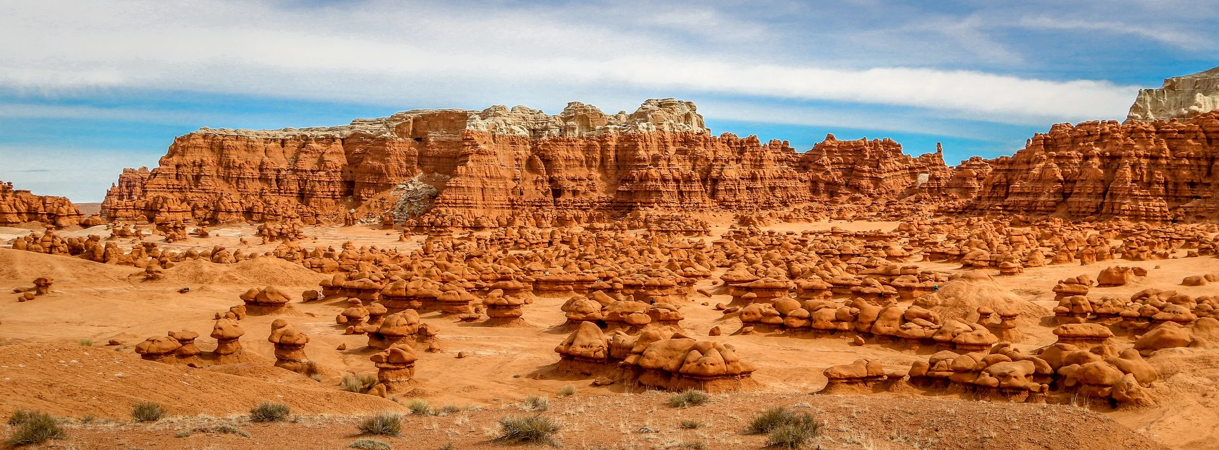
Goblin Valley is another of Utah’s incredible fantasy landscapes. It’s a place that quickly captures your imagination and leaves you smiling the whole time you are there. Located in a remote part of Emery County, you have to make an effort to get to Goblin Valley, but you’ll definitely be glad you did. The “goblins” are technically hoodoos, made of soft lower layers of sandstone and capped with a harder layer which causes water to erode them from the outside in instead of from the top down. The main amphitheater has thousands of goblins and is an incredible place to just wander, especially during the edges of the day when the low light illuminates the goblins and cooler air prevails. Beyond the amphitheater are other dream landscapes to explore, including the caves known as the Goblin’s Lair and the Goblette’s Lair, the Toadstools, beautiful Wild Horse Butte and the amazing Wild Horse Slot Canyon. Most people spend about an hour in Goblin Valley, but the longer you spend, the more you’ll find to keep you busy. Thanks to the prompting of my friend, Jack, I spent the whole day there and was definitely happy that I did. I hope you enjoy these photos from beautiful Goblin Valley - Magic in the Red Rocks of Utah.
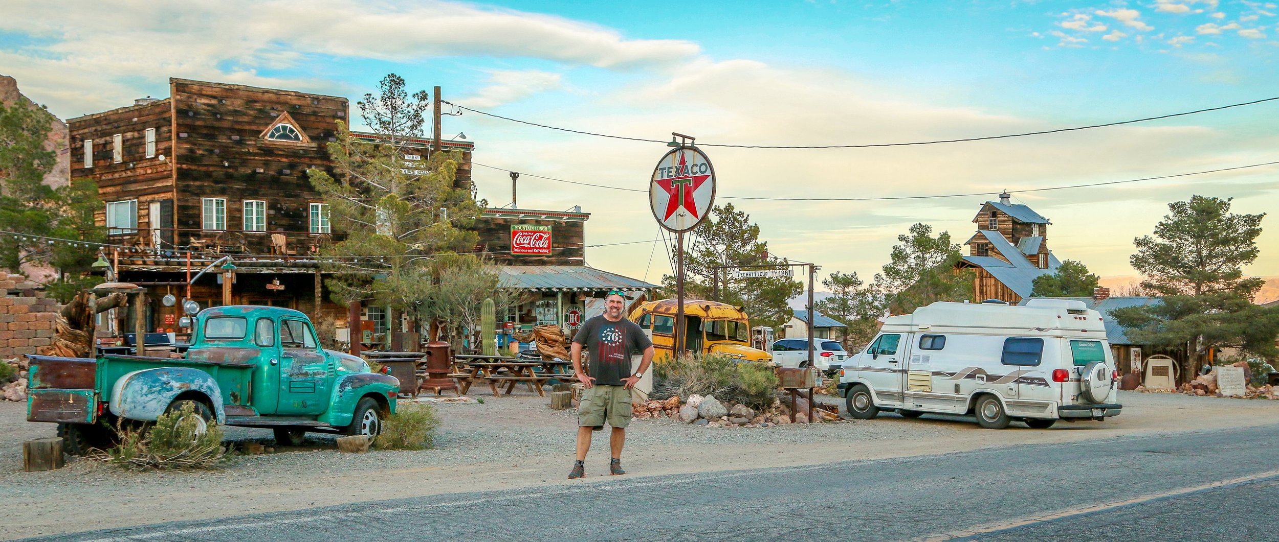
I absolutely loved visiting this old ghost town just south of Nelson, Nevada. It’s located near the site of the old Techatticup Mine in the heart of El Dorado Canyon. Gold and Silver were discovered in El Dorado Canyon in 1859 and a huge population influx soon followed. It grew to be a rough and sinister town and was named for Charles Nelson, a mining director who was killed in his home. Because of its proximity to the Colorado River, it was relatively easy to get people and supplies in and out when compared to other mine locations. The mines in the area were active until 1945, producing several million dollars worth of minerals. Today, the town is privately owned and open to visitors during daylight hours. It’s clearly staged for photography but that didn’t make me love it any less. It seems as though a lot of weddings are held on the property as well. I hope you enjoy these photos from the colorful ghost town of Nelson, Nevada deep in the heart of El Dorado Canyon.
The Lincoln Highway was the original road-tripping route across the country. Dedicated on Halloween, 1913, the Lincoln Highway stretched 3,389 miles from Times Square in New York City to Lincoln Square in San Francisco. It was really the first transcontinental route designed specifically for automobiles and became known as The Main Street Across America. The stretch of the Lincoln Highway that crossed Nevada was planned along a well-trodden path. This route had previously served as a stagecoach route, the main trail for the Pony Express and the transcontinental telegraph also ran along this path. Many years after the highway was built, in 1986, Life magazine called this stretch of road across Nevada “The Loneliest Road in America”, and that wasn’t meant as a compliment. Nevadans, however, loved it and set out to make it a state scenic byway, erecting signs, creating a passport and marketing it to outsiders as The Loneliest Road. It connects fascinating old mining towns like Austin, Ely and Eureka and passes by old Pony Express stations, vast expanses of desert and the ruins of Fort Churchill (now a state park). I’ve made this run across Nevada several times and always really enjoyed it. There’s a lot of history out there and some great bars along the way as well. I hope you enjoy these photos from my time traveling down Nevada’s section of Route 50, The Loneliest Road in America.
Breathtaking beaches, glacier covered mountains and incredible temperate rainforests all wrapped up in one amazing National Park? You must be talking about Olympic. Designates as Mount Olympus National Monument by Theodore Roosevelt, the area officially became Olympic National Park in 1938. Covering a massive 1442 square miles, the National Park covers most of Washington State’s Olympic Peninsula. 95% of the park is designated wilderness, meaning you’re going to have to hike in if you want to really see it.
I have been to Olympic before, but really just to catch the highlights at the Hoh Rainforest, Second Beach, Crescent Lake and Marymere Falls. On this trip I spent almost two weeks in the area and saw so much more of what the park had to offer. I did a four day, three night backpacking trip up the Hoh River Trail to Glacier Meadows and then a three day, two night hike around the High Divide/Seven Lakes Basin Loop, both of which were spectacular. I also visited the Quilault Rainforest, Ruby Beach, and Sol Duc Falls while I was there and stopped into the beautiful park lodges at Quinault Lake and Crescent Lake. The highlight for me was definitely the namesake Mount Olympus, but the quiet nights, the sound of water and the incredible wildlife also made me happy. I hope you enjoy these photos of the magical region of Olympic National Park.
White Salmon is a cute little town up on the hill on the Washington side of the Columbia River Gorge. The area was historically Klickitat territory and was first settled by the Joslyn family in 1852. Cattle farming, timber, salmon fishing and wheat were the early industries in White Salmon, and later fruit farming and tourism would add to the economy. Today, the population rests right around 2500 people. It was the white salmon crosswalks that drew me in and the cute businesses and signs that kept me there. I wasn’t in White Salmon for long, but I really enjoyed my time there and I hope you enjoy this small handful of shots from the town ‘Where the Sun Meets the Rain”.
The Columbia River is the largest river in the Pacific Northwest, and also the most important. It has always served as a trade route from the interior to the coast from the time American Indians paddled their dugout canoes up and down the river to the tall ships of the fur trade to modern trade ships of today. It also has several major dams which provide much needed power to the region and the river also serves as the border between Washington State and Oregon. The incredible waterfalls on the Oregon side bring in tourists by the thousands, but the small towns of the Washington side are friendlier and more livable. It gets hot out there, and it got too hot for me to stay too long and I ended up cutting my visit a little bit shorter than I would have liked, but I still had a great time out there. I hope you enjoy these photos from the beautiful Columbia River Gorge…
Bandon is an adorable little town of about 3,300 people on the southern Oregon coast. Originally Coquille Indian land, it was first settled by people of European decent in 1853. The town was established in 1873 by four men from Bandon, Ireland in County Cork and named for their old world home. Cranberries were introduced into Bandon in 1885 by Charles McFarlin of Massachusetts and have been grown and harvested successfully in the area ever since. Tragically the whole town burned to the ground in 1936 in a fire that claimed eleven lives. It has risen from the ashes and rebuilt as a charming coastal town with a lot to offer.
Bandon was probably my favorite town on the whole Oregon coast. The Old Town area was full of art and color and I loved just walking up and down the waterfront. The beaches were absolutely stunning with so much more to see than just the famous Face Rock and an evening stroll proved to be an excellent choice. The history museum, housed in the old City Hall, was one of the best local history museums I’ve ever been to in a town this size. Of course I loved the hand-painted signs around town, the beautiful carved wooden sculptures and the Coquille River Lighthouse. Of all the towns I visited in my first week along the coast, this was the one that stood out and a town I will definitely return to. Thank you, Bandon, for a wonderful stay. I hope you enjoy these photos from Bandon, Oregon.
When I left you last week, I was at the wonderful public library in Brookings. From there I was planning to make my way up into the Samuel H. Boardman Scenic Corridor which covers some of the most beautiful coastal scenery in the south of Oregon. Unfortunately the fog just wouldn’t lift that day, so I spent a lot of time hanging around the beach and reading which was also nice. The skies finally cleared to some extent around 6pm so I hustled my way up the coast, pulling off to take a bunch of photos along the way. I wish I had had more time to do it, but it was really magical nonetheless and I had some amazing views. The broad beaches and sea stacks are really something to see and I’m really glad I got a little bit of sun to take some photos with. In the end, I only made it as far north as Gold Beach before it got dark, but it was a lovely evening…
Hello Everyone! It is wonderful to be back writing This Week on the Road, but not nearly as good as it is to actually be back on the road. I spent the last year dreaming of the open highway ahead of me and the wind in my hair. As much as I love my hometown and my family and friends, I missed the natural landscapes around which I have built my life. For the rest of 2025 I plan to surround myself with beaches and mountains, waterfalls and glaciers, sunsets and wildlife. I have also learned in my life that while some people thrive on routine and knowing their surroundings, I live for new places I’ve never seen or visited. I may love the museums and bars and coffee shops at home, but for me there is always something special about walking into the unknown – a town or restaurant or music venue I’ve never been in before. I can spend my time looking around and picking up on the details of the place, eavesdropping on the local gossip. I like being the stranger in town. It’s a role I embrace. This last week+ has been a wonderful reintroduction to the world of travel and vanlife for me, with a few familiar places, a few familiar faces and a whole lot of something new.
Hello Everyone!
It’s been a busy week out here on the road in Southern California. This week has taken me from the desert to the mountains to the city and back again. I got some skiing in, went to a local fair, drove down Route 66 and went to the original Renaissance Festival in Irwindale. As the week is ending, I’m making my way up the east side of the Sierra Nevada Mountains and enjoying seeing all the snowy peaks out my driver’s side window. I’m getting closer and closer to starting my tour season and trying to get as much in before I do as I can.
After I finished writing this post last week, it was late in the day so I spent the night there in Twentynine Palms. I went out for a surprisingly excellent salad at the Cactus Grill and then headed out to the Tortoise Rock Casino for the night. This casino is run by the Twenty-Nine Palms Band of Mission Indians and they were incredibly welcoming of overnighters so long as you checked in with security. I enjoyed a little blackjack and walked out $10 up which is definitely a win.
I was up and out early on Thursday as I needed to grab some groceries and a few other things in the morning before I got started with my day’s travels. Once I was all stocked up, I headed out to the Big Morongo Canyon Preserve just off Highway 62 in the Morongo Valley and I’m really glad that I did. This preserve is located in Sand to Snow National Monument and is run jointly by San Bernardino County and the Bureau of Land Management. It’s not a huge place, but it offers several miles of trails and boardwalks in very different environments. The wildflowers were in full bloom and there were plenty of birds out there to keep me company (and apparently a few rattlesnakes, but I didn’t see any). It was a wonderful place to spend the morning, get some fresh air and stretch my legs. From there, I jumped on Route 38 in Yucaipa and started making my way up into the San Bernardino Mountains. The road was pretty steep and we struggled a bit with the heat as I didn’t know we would travel up to almost 9000’ on our way to Big Bear Lake. Thankfully it got considerably cooler the higher we went and right when I thought we were going to have to pull over to avoid overheating, we crested the pass and started dropping down the other side. I got to Big Bear Lake with enough time to wander around the beautiful namesake mountain lake for a bit before the sun went down. From the north side of the lake I could see Snow Summit Ski Resort and was impressed by how much snow was on the mountain. The Village at Big Bear Lake is a cute little mountain town which I would really enjoy for the next two nights.
I was up early the next morning and stopped in to a shop called GetBoards right there in town to rent my ski equipment for the day. The people working there were great and my equipment was considerably cheaper than it would have been at the resort. Once I was all outfitted I went up and hit the slopes for the first time since I was in Western North Carolina five years ago. The snow was remarkably good and most of the lifts and slopes were open. I loved the west side of the mountain which is full of long, easy trails for “skill development”…
The Channel Islands are an eight island archipelago off the coast of Southern California and five of these islands make up Channel Islands National Park. The waters surrounding these islands are also protected as a National Marine Sanctuary. The Channel Islands were created by tectonic forces 5 million years ago and have always been islands, although they were closer to the mainland during the last ice age when the sea levels were lower. Because of their isolation, the islands are home to several endemic species of plants and animals meaning those found nowhere else on Earth.
People have inhabited these islands for a very long time. In fact the oldest human remains ever found in North America, dating back 13,000 years, were discovered on Santa Barbara Island in 1959. In more recent times, the northern islands were home to different bands of the Chumash people while the southern islands were inhabited by the Tongva. Juan Cabrillo observed the islands on his 1542 voyage up the coast and in more modern times the islands were used to raise sheep and cattle. They were protected as a National Park in 1980.
I was unfortunately only able to visit one of the islands in Channel Islands National Park during my stay, but Santa Cruz is the biggest and most accessible and made for a wonderful visit. I stayed in the campground at Scorpion Ranch for three nights and was able to hike to Cavern Point, Smuggler’s Cove, Potato Harbor and the incredible Montañon Ridge. For the last two days I was on the island, there were only 19 other people there which made for a peaceful and incredible stay. It was hard to believe that we were only an hour car ride and an hour ferry ride from the second largest city in the country, but it sure was nice to be there. I can’t wait to go back again. I hope you enjoy these photos from Channel Islands National Park.